View Larger Map


When I did my recent piece on Governors Park, I thought I'd found the most absolutely unknown and obscure city park in downtown Portland. I was wrong. I was looking at the city's official Walking Map of Southwest Portland yesterday, and the words "Frank Knight Park" caught my eye. Hmm. Okayyy. Never, ever heard of it, I said to myself. Never even seen it on a map before. And talk about centrally located -- if you live on the west side and commute in to downtown, you drive right past the place every day. It's a small plot of land between SW Montgomery Drive and steep SW Mill St. Terrace, literally right across the street from where US 26 eastbound exits the Vista Ridge Tunnel. (Google Map of the area here) It's the steep, forested hillside on your right just as you leave the tunnel (which puts it in the upper left-hand corner of photo #4, from one of the Vista Tunnel traffic cams). When I say steep, I'm not exaggerating. "Ridiculously steep" would not be exaggerating. I visited the bottom end of the park because I didn't feel much like hiking uphill, and Montgomery Drive is a windy little road with no sidewalks, full of gigantic Lexus SUVs rocketing along at top speed -- and the drivers are all on the phone, of course, and oblivious to their surroundings. Gentle Reader(s), I try to go the extra mile for you guys and "dig a little deeper" and all that , but I usually draw the line at actual physical danger. I imagine the Montgomery side of the park looks a lot like the Mill side, except that you're looking nearly straight down instead of nearly straight up. At Governors Park I was at least able to wander in and look around a token amount. Here, not so much. There's no obvious way in, unless you have mountaineering gear, or a helicopter, or tentacles with suction cups for arms, or whatever.


The city parks department, understandably, doesn't give the place much attention. As I expected, there's no official Parks Department sign, at least on the Mill side. The official website refers to it as the "Frank L. Knight Property", and has very little to say about it: It totals 0.56 acres (slightly larger than downtown's O'Bryant Square, or an average Park Block), and the city's owned it since way back in 1941. As for amenities, there's the usual "Includes natural area". When the city uses this term, it can mean anything from a stand of old-growth trees to an abandoned nuclear bunker, and maybe even the city isn't 100% sure what's there. The parks department page, and the mention on the walking map, seem to be the only two sources of info about the park on the entire Internet. And they don't even agree on the name of the place. Since the city can't manage to agree with itself, I'm going to adopt "Park" instead of "Property", and keep the middle initial, because a place this obscure ought to have a grand name. You could just call it "Knight Park" if you ever had a reason to, although Lincoln County on the coast already has a park by that name As far as I can tell, this post will be the first-ever writeup about the place by anyone other than the city government itself.

I have all sorts of questions the city hasn't managed to answer. First, who was this Frank L. Knight guy, anyway? If he was the previous owner of the property, how on Earth did he convince the city parks department to buy it? It's not like you could put a soccer field here. Maybe you could put a scenic viewpoint up top, or something, if the place wasn't full of tall trees. A mountain goat sanctuary would be logical here, too.
Two theories I'm batting around. First, the city ended up with the property due to unpaid back taxes. It became public property right around the tail end of the Depression, so this seems possible -- in which case the good Mr. Knight probably wasn't the former property owner. Second theory, the current "Property" is what was left over after the tunnel was built, and the city had acted with great foresight by buying this crucial piece of property early on, well before they started digging the Vista Tunnels.
Or maybe they just bought it sight unseen, and Mr. Knight retired to Palm Springs on the proceeds, chuckling gently to himself all the way.
Updated 3/14/11: Thanks to the magic of the Multnomah County Library's historical Oregonian archives, we have a few answers. Frank L. Knight owned Knight Packing Company, a produce company with an old-style address of 474 East Alder, which ought to place it in the present-day Produce Row area. The July 14th, 1946 Oregonian had an article about a posthumous citation for philanthropy he was awarded for bequeathing $700k to Pacific University in Forest Grove. That's a lot of money now, and would have been an enormous amount of money in 1946. The article includes a photo, and says of him:
Mr. Knight, who was born in Des Moines IA in 1884, made his first home in the northwest in Tacoma, Wash., where he operated a shingle mill. In 1899 he moved to Portland, bought a vinegar company, and reorganized it as the Knight Packing company, of which he was president and manager until his retirement in 1936. From 1925 until his death he served Pacific University as a trustee.
A November 22, 1946 article mentions that he also left money for the construction of the downtown YWCA building, which still exists.
As for the park, I've come across exactly 4 mentions of it in the Oregonian:
May 4, 1941:
Park Property Offered - Gift of view property near S.W. 19th avenue and Montgomery street has been offered the city council by Frank L. Knight, 1890 S.W. Vista avenue. The property is west of and adjoins S.W. 19th avenue and Montgomery and also takes in what would be 19th avenue if it were extended. All taxes and liens have been paid and the property can be turned over at any time, said the offer, which will be considered Wednesday.
The city council took its time considering the offer, as the next mention of it I've found was not until late December of that year.
December 21, 1941
:
Gift Ordinance Due - The city council Wednesday will have an ordinance to accept the gift of Frank L. Knight, 1890 SW Vista Avenue, of two parcels of land for park purposes and to express the appreciation of the city for the gift.
December 25, 1941
:
CITY GETS VIEW LOTS
The city council Wednesday accepted with thanks two view lots offered the city for park purposes by Frank L. Knight. The property is on S.W. 19th avenue near Montgomery drive and was given the city free and clear. An expression of appreciation for the gift will be made by the city to Mr. Knight.
As you can imagine, most of the surrounding articles relate to World War II. On the same page as the December 25 blurb is a piece titled "Women's Stockings New and Valuable Defense Aid", which is right next to "Alien Travel Restricted", alien meaning Japanese, German, or Italian. The December 21 blurb is on the same page as a notice to homeowners that their Christmas lights need to be turned off in the event of a blackout.
After that, the park appears by name exactly once, on October 25, 1970. It's part of a groovy-looking map of the city park system, which also appears to be a thinly veiled Frank Ivancie campaign ad. When your goal is to dazzle the public with the city's vast park system, I suppose you need to include the really obscure ones too. So it also includes Governors Park, all of the "East Park Blocks", Talbot Park, and "Block 101, Mocks Crest" at N. Willamette & Bryant. The last two spots are really quite tiny, as I've pointed out before, so the map's a bit on the misleading side if you ask me.
In any case, those brief mentions also seem to answer the "why" question, indirectly. The Vista Ave. address given for Mr. Knight is just uphill and southwest of the park, and if I'm looking at the map correctly the "view lots" protect the Knight house's view of Mt. St. Helens, or at least they would have in 1941 when Mt. St. Helens was a bit taller than it is now. And maybe they still do. This is a rare case where I actually wasn't cynical enough when trying to think of reasons the park exists..

I don't really know what you could do with the place. A heroic private developer could probaby cantilever a house or two out over the hillside, but as a park... One possibility would be to make the place a "vertical park", with a staircase from the bottom to the top. The West Hills are absolutely full of weird and obscure public staircases, so that it's actually a lot easier to get around the area than you might think (this is actually why I was looking at that walking map in the first place). So I'm suggesting we put in a few more staircases, at least one here and one at Governors Park, but with a modern twist: Design them to accomodate runners. I expect running up the stairs here would be a great workout, to say the least. And if you blow out a knee on the way up (or down), OHSU isn't far away, and it'd be a golden opportunity to check out that world-class sports medicine department they're always bragging about. Making the stairs ADA-compliant would be very, very difficult, but if you had to, I guess you could always put in a municipal elevator, like they have down in Oregon City. There's just the "simple" matter of finding the money. It would help a great deal if it turned out that Frank Knight was an ancestor of Phil Knight, the Nike guy. There's no real reason to believe that, though.
On Wednesday, I took a few photos of the park, or of what seemed to be the park, since the place isn't marked, obviously. The top photo is the least unremarkable of the bunch. You probably can't get a nice, appealing photo of the park as a whole, since it's pretty much just a chunk of steep hillside covered in trees and scrubby little bushes.
I went back Thursday morning to try to get some better photos of the place, and ended up taking a bunch of close-ups, including the last 4 pics here. It's not all blackberries and wild roses there, but ivy and vine maple are nowhere near as photogenic. The last photo's looking towards downtown from the park... or from Mill right next to the park if we're going to split hairs here.
Here's a house for sale on Mill St. Terrace -- it looks like they're asking a cool $10M for it. Ten. Million. Dollars. For a house perched right over a freeway, no less. I can't see a lot of people falling for that, but I guess you only really need one. Some nice photos of the view from here, regardless.
The vicinity of the park is sort of interesting. Just east of the park, a narrow street called Cable Avenue branches off of Mill. Snyder's Portland Names and Neighborhoods describes the street thusly:
.
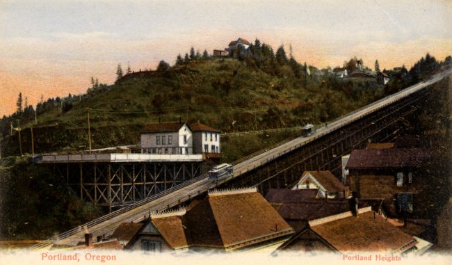
For years, this was an un-named alley. Then, in 1892, a city ordinance designated it Cable Street. The name referred to a cable system which pulled streetcars up an inclined trestle to a hillside terminus at Spring Street. (At that time, 18th Avenue was still called "Chapman Street.") The cars were drawn up the trestle by attaching to them a cable actuated by a system of weights. Cable Street was almost under this trestle. The cable line ceased functioning in 1904, when the "Vista Avenue Bridge" was built across Canyon Road, providing a moderately inclined route which streetcars could use to get to the "Heights".
I seem to recall that when the Westside MAX line was under construction, workers discovered a bunch of mechanical bits left over from the old cable car line, right around the new MAX station at 18th & Jefferson. There were promises made about accomodating some of these old bits into the decor at the station, but nothing seems to have come of that. TriMet has a page about our city's brief dalliance with cable cars, as does The Cable Car Homepage, and PDXHistory has a nice picture of the old trestle. Over a thousand feet long, rising at a 20% grade. Yikes! Take that, aerial tram!
More tidbits about the local area:
- An excerpt from the book "Portland Hill Walks" discusses the area.
- A walking tour of another portion of Montgomery Drive, further up the hill.
- The twin Vista Tunnels made someone's list of historic tunnels
- The Mercury points us at a funny YouTube clip created from police videos of the Zoobombers biking through the eastbound Vista tunnel.
- If you're of a geekier bent, here's a bit about the tunnels' lighting systems, in case you were curious or whatever.
- Some photos of the Goose Hollow / King's Hill neighborhood, just to the north and downhill from the park. The park isn't quite in Goose Hollow, and isn't quite Portland Heights (i.e. the rich neighborhood up top) either. Which I guess makes it a "gateway", one of those high-concept things that architects & designers really get their rocks off about. Someone should inform Randy Gragg, or at the very least the "Portland Architecture Blog" guy.
- If you hike around the area much, sooner or later you'll need a beer. And you're in luck: Former Mayor Bud Clark's cozy Goose Hollow Inn is right at hand. Mmm... Beeer....
7 comments :
Great article. I walked by the park today and gorged myself on the roadsie blackberries!
I recently acquired an antique Knight's Apple Cider Vinegar bottle. Seems that the company founder had a sense of humor in that the company logo had a medieval knight riding a ridiculous pickle.Since my last name is also Knight, and being a genealogy sleuth, I'll be checking out more info about Frank. My grandfather was born in IA about the same year. Maybe a longshot, but the "trivial pursuit" is enticing.
The land is now for sale by the city
Thank you so much for this post. I had never heard of Cable Ave until seeing it in the title of a Henk Pander painting of the 19080 Mount St. Helens eruption that is now on exhibit at the Portland Art Museum. In researching Cable Avenue, I saw Frank L. Knight Park close by and wondered about it.
A documentary film telling the story of the Knight Packing Company should be developed. Apparently, Mr. Knight was a benevolent owner who hired a diverse workforce. There may be some very interesting stories about the company, those who worked their and its founder.
*there
I have found 4 jars embossed with Knight Packing on the base. Two are different size mustard jars (one with the label). Two appear to be mayonnaise jars (a quart and a pint).
Post a Comment