[View Larger Map]
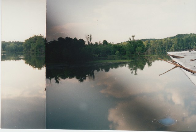
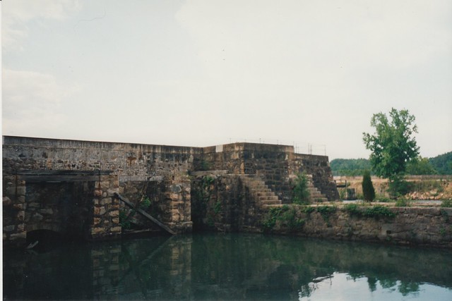
Today's adventure takes us out to rural Yamhill County, to Lafayette Locks County Park, on the Yamhill River near the town of Lafayette. It's hard to believe today, but back in the early 20th century the little Yamhill River had a bit of commercial steamboat traffic on it, shipping Yamhill Valley crops to market. Shipping was impeded by some rapids (known somewhat generously as "Yamhill Falls") at this point in the river, so local boosters convinced the US Army Corps of Engineers to build and operate a modest lock system, the remains of which you see here.
The old locks were on the far side of the river and aren't accessible from the park, and the riverbank's thick with trees these days, so you really don't get a good look at things like you do at Cascade Locks. Nor is there good access to the river unless you're up for a muddy scramble down a steep bank. Still, the park has a large and well-maintained picnic area, and it's a pleasant place to stop even if the park's signature attraction is across the river and behind some trees.

The locks are a little-known historical footnote, and usually it's hard to find a lot of information online about something this obscure. But back in 1990 the Oregon Historical Quarterly published a long two-part article about the locks: "From Dream to Demolition: The Yamhill Lock & Dam", by Suann Murray Reddick, in Vol. 91, Nos. 1 and 2, which as far as I can tell remains the definitive work on the Lafayette Locks. The previous link goes to a JSTOR preview of Part 1; if you have a Multnomah County library card, and you want to read the full text of both parts of the article, you can get PDFs at 2 permalinks: Part 1, Part 2. The locks are also mentioned briefly in an earlier article, "Tributaries of the Willamette: Yamhill, Santiam, Calapooya" ( Vol. 44, No. 2 (Jun., 1943)), by Ruth Rydell, giving a perspective on them while they were still in operation.
The two parts of the Reddick article come to about 90 pages. I've read the whole thing, along with the relevant parts of the Rydell piece, and I'll try to summarize the tale briefly. But if that's still TL;DR for you, I'll pass along a couple of other links first: Here are three historical photos, a YouTube video about rafting the rapids here, and a short blog post with a few photos. Also, the City of Dayton, downstream of the locks (and home to the Ferry St. Bridge), has a short article on their website about Yamhill river shipping. Dayton was effectively the head of navigation on the river until the locks came, and the article indicates river traffic had dried up there by the 1920s.

Now back to our story. Part 1 of the Reddick article details the decades-long struggle to get the locks built. Yamhill Falls was one of the few places the Yamhill River could be forded, so an Indian trail passed through here prior to European settlement. Settlers saw the value of the area early on, and the falls were homesteaded in 1840, well before any sort of local government had been instituted. By the 1850s, the Yamhill Valley had become a prime agricultural area, and initially the only way to get products to market was by boat (the same state of affairs encountered at Butteville, Cornelius, and elsewhere.)
The falls, puny as they were, still presented an obstacle to river traffic, and the first proposal to build locks on the river came in January 1859, a month before Oregon statehood. This privately financed proposal went nowhere, as did further attempts continuing into the 1870s. At that point railroads had come to the Yamhill Valley, but exorbitant freight charges led local boosters (but never quite enough investors) to see an opening for a cheaper river-based alternative. After the last private proposal fell through in 1876, attention turned to convincing Congress to fund the locks instead. This took another twenty years of lobbying, with a reluctant Army Corps of Engineers repeatedly surveying the area and coming up with different (but never very positive) recommendations every few years. Finally, in 1896, the political pressure succeeded, and Congress appropriated up to $200,000 toward the locks proposal.

Part 2 picks up with the construction of the locks. Construction turned out to be more difficult than expected, due to problems with flooding and weak, eroding river banks. The locks finally opened on September 22nd, 1900 -- rather than the original target of December 31st, 1898 -- and construction ran to over $72,000, about 20% over budget. The article points out that the locks were essentially obsolete the day they opened; the first proposal had come in 1859, when much of the area was still howling wilderness, but four decades later the Yamhill Valley had electricity, telephones, multiple railroad lines, and a few paved roads, and riverboat traffic was declining even on the Willamette and Columbia.
Within a year, the cheaply built locks proved inadequate to the task, and sustained serious damage due to the same flooding and erosion issues it had encountered during construction, as well as collisions with drifting riverboats and errant logs from log rafts. The Corps of Engineers invested an additional $22,000 in repairs just in the first year. A 1903 study gave a couple of options for strengthening and upgrading the lock and dam, but suggested they weren't worth investing in as the locks saw very little traffic. The lack of traffic was something of a chicken-and-egg problem; the locks were inoperable during high river levels, and shipping companies were unwilling to risk having their boats stranded on the upstream side of the locks in that situation. This absence of traffic in turn made the Corps not want to bother fixing the dam's high water problems.
So by 1903 traffic through the locks had essentially petered out already, only three years in, and the Corps of Engineers floated a serious proposal to abandon the locks altogether. Naturally there was a local public outcry, and suspicions that the railroads were in on the proposal. The matter was forwarded on to distant Washington DC, where it ran into bureaucratic inertia: The locks were neither abandoned nor upgraded, but simply maintained in their current state and repaired every so often.
Various schemes for shipping people and cargo on the Yamhill River came and went, and none lasted long. By 1912, the article notes, just 386.6 tons of freight and 327 passengers used the locks in the course of the entire year. This minimal level of traffic continued into the 1920s, and the Corps classified the locks as "proper for abandonment". Rydell quotes an Oregonian writer to the effect that, during this time, there was so little river traffic the locks were opened every ten days "just to shake the rust out and to show that all is well."

Traffic picked up in the late 1920s thanks almost entirely to log rafts, and local farmers became increasingly interested in the reservoir behind the dam as a source of irrigation water. Another study was commissioned in 1931 on options for upgrading the dam, but again nothing came of it. Log traffic increased through the 1930s and peaked in 1943, when 101,981 tons of logs passed through the locks. Rydell mentions that in 1942 (the previous year) an average of two log rafts per day had passed through the locks. At that point there was every reason to assume this level of traffic was the new permanent state of affairs.
The log raft trade declined quickly after World War II, however, as the Yamhill Valley started running out of trees, and modern log trucks took much of the remaining business. By 1953 the locks were back on the chopping block, thanks to the loss of traffic and Congressional budget cuts. As in 1903, there was a public outcry, in part about the locks themselves, and in part about the adjacent park, which had been developed by the first lock keeper back when the locks opened. This time, local protests proved futile, and the locks and dam were officially abandoned on February 4th, 1954. The newly formed county parks department took over the locks and the park roughly a year later.

Back in 1908, the state's Deputy Fish Warden had already raised alarms about the dam as a barrier to migrating salmon, and he somehow convinced the feds to install a primitive fish ladder at the dam. The article doesn't mention any further concerns about fish until after the abandonment of the dam, at which point the Oregon Fish Commission stepped in and raised new concerns about the dam and salmon. The dam was still used for irrigation water at that point, and a farmers-vs.-fish battle ensued that should seem all too familiar to anyone who witnessed Southern Oregon's Klamath River water wars just a few years ago. And similar to the Klamath situation, the state sided with the fish. Or more precisely, it sided with sport fishermen who thought the river looked promising. By 1960, the Oregon Fish Commission was insisting that the county had to provide adequate fish passage, or the dam would have to be removed. Meanwhile, the abandoned and unmaintained locks and dam continued to deteriorate, and the county had no funds on hand to repair them. They county sided with farmers and dragged its feet cooperating with the state, and several years of legal wrangling ensued. Then, in 1963, a subtle and little-noticed change to state law removed the county's power to block state action on the dam, and on September 18, 1963 the state dynamited the dam, to the great surprise and dismay of the local community. A 1976 proposal to build a shiny new dam for irrigation went nowhere, and contemporary (circa 1990) discussion around building a new dam or at least creating a fish pond at the old locks seems to have come to nought as well.
The article goes on to point out that, from a sport fishing perspective, the promised benefits to fish may have been somewhat oversold, and (as of 1990) neither coho nor chinook salmon populations had become established in the river. It isn't indicated whether there had ever been coho or chinook in the river before the dam went in, which is the key point ecologically speaking. It's quite possible nobody knows.
Another thing the article barely mentions, but which I'm intrigued by, is the fact that the old Yamhill Falls site was a major river crossing prior to European settlement, so presumably local tribes had been using this spot for thousands of years before pioneers arrived with their money-making schemes. So the area is at least potentially an archeological site, albeit a heavily disturbed one. I wonder if anyone's ever taken a professional look at it?

Anyway, thanks for reading this far. I don't usually do blog posts quite this long anymore, but I basically go wherever the source material takes me. As I mentioned earlier, the park isn't terribly exciting these days even if you're a history nerd like me. But it does preserve an unusual bit of local history, and it's certainly a change of pace from other better-known Yamhill Valley attractions: The aviation museum, the big Indian casino out west of McMinnville, pretentious wineries and art galleries everywhere, and that sort of thing. So if you go, take a picnic lunch along, slow down, and just watch and listen to the river for a while. It's quite nice, really.


