Saturday, December 28, 2013
2013: The Year in Instagram Cat Photos
More after the jump. It's possible I take too many Instagram cat photos.
Friday, December 27, 2013
Thursday, December 26, 2013
Birds on a Wire
Here are a couple of photos of Birds on a Wire, the kinetic water sculpture on SE Water Ave. across the street from OMSI. The building in these photos is part of a PGE electrical substation, and the art here is the collection of pipes near the top of the building. The pipes fill with water, from internal piping that you can't see here, and a certain fill level unbalances them, and they tip over and empty into a pool below (which you also can't see, due to a relatively recent wall around the substation). I would have taken a video to give a better idea of what happens, but it never seems to be running when I'm there.
OMSI has an info page about the fountain, which appears to have been created for the 1995-96 "Water Works" exhibit and not updated since then. I think the exhibit overlapped a little with the years I worked there, if I remember correctly, and that was a long, long time ago. I know I recognize some of the names in the site credits, anyway. If you like the Space Jam movie website, or you miss Geocities, you'll love OMSI's Water Works pages. Anyway, the page about Birds on a Wire has a couple of video clips of it doing its thing. Unfortunately as a circa-1995 website the video clips are postage stamp-sized QuickTime movies, but they're the only ones I've been able to find of the fountain in operation. In case the OMSI site goes away, here's their description of the fountain:
This water sculpture is a popular attraction at OMSI. Finished in 1995 by David Curt Morris, this fountain is very similar to the Deer Chaser fountain, but on a larger scale. Large metal pipes move in rythmic motions that remind one of birds drinking from a fountain.

A 2001 profile of Morris for the Reed College alumni magazine mentions that he also created the Columbia River Crystal sculpture in downtown portland, which I'm a big fan of. It and Birds on a Wire look nothing alike, and I wouldn't have guessed the connection on my own. A 1994 First Thursday blurb in the Oregonian, for a show at the Laura Russo Gallery, mentions the fountain in passing:
New York artist David Curt Morris is an architect with a predilection for water and engineering. The Oregon Museum of Science & Industry considered him the perfect person to create a sculpture for its new facility. That piece will be completed in 1994, but in the meantime his studio work made of bronze, glass and water is on view at the gallery. Morris is the son of Carl and Hilda Morris, the late Portland artists.
Morris is a common surname, of course, so I would't have guessed this connection on my own either, but Hilda Morris created Ring of Time, the abstract sculpture outside one of the Standard Insurance buildings that looks either like the Guardian of Forever or an onion ring, depending on how nerdy and/or hungry you are. I'm fond of it too, and I had no idea there was a family connection here.
In any case, another profile, for a gallery in Beijing, mentions that Birds on a Wire won an award for excellence by a local engineering society. Details of the award don't seem to be online; it's possible the engineering society didn't have a website yet back in 1994 or 1995. The 1994 date in the Oregonian article might be when it was originally supposed to be done, by the way; my recollection is that it took quite a few months to get the bugs and kinks worked out of it. But then, I wasn't personally involved in the project and mostly just heard office gossip about it, and it was quite a long time ago, and I may be misremembering the whole thing. The more I think about it, this entire 1994-95 business is making me feel old. Have I mentioned I have yet another birthday in a few days? Because I do, and this time I don't have tickets to Hawaii or Vegas or anywhere. Sigh.
Clackamas River Railroad Bridge
[View Larger Map]
Some time ago, I did a series on bridges along the Clackamas River (or at least the ones near the Portland area). In a post about the ugly, utilitarian I-205 bridge near High Rocks, I had a little addendum about the railroad bridge behind it:
As an added bonus, right behind the freeway bridge is a railroad bridge that now belongs to Union Pacific, although it apparently still has "Southern Pacific" written on it in large letters. It isn't really possible to take a better photo of the railroad bridge without a.) shooting from the freeway bridge (hopefully while someone else is driving) b.) trespassing on the grounds of someone's fancy riverfront home, or c.) riding an inner tube down the river with a camera and hoping it doesn't get wet. A site covering Clackamas River Bridges appears to have chosen option a., so you can check those out if you're curious. But as far as the bridge project goes, I'm going to consider the railroad bridge "done" without resorting to any of the above options, since it does already appear, a little, in the photos here.
I'm still not really sure how to get unobscured photos of the railroad bridge; in the photo above, you can just make out one of the bridge piers behind the I-205 bridge, and you just sort of have to imagine the rest somehow. Admittedly I haven't actually gone back to look for a better angle, so in this case it really is for lack of trying. Still, the fact that I just tacked this onto the end of another bridge post sort of felt like cheating, and I'd really hate to anger the internet police, so I never quite took it off my todo list. I can't show it to you very well, but at least I can try to tell you about it, and if I manage to get better photos sometime later I can always edit this post and add them.
There's a Structurae page about this bridge, and that page has a photo of the bridge from the upstream side, apparently taken while peering over someone's barbed wire fence. It's just a 1950s metal girder bridge, nothing terribly interesting about it other than the fading "Southern Pacific" sign. A railfan page about Amtrak's Coast Starlight line has a similar photo, this time with an Amtrak train on it. Another site has a couple of forum threads speculating about the history of rail bridges on the Clackamas River, and looking for photos of the current bridge's predecessor, which crossed further downstream near the 82nd Drive Bridge.
It turns out there have been railroad bridges here for a very long time, by Oregon standards. An item in the November 20th, 1869 Oregonian mentions that the first bridge has come to a bad end:
The loss of the bridge over Clackamas river, which was just approaching completion, is quite a serious blow to the progress of the railroad, but it will not prove disastrous. It will necessitate still more energy and outlay in order to build the first section of road within the proposed time; but Mr. Holladay is not a man to be checked by such a misfortune. The energy which has for several weeks been so manifest in the construction of the road will be redoubled, and every obstacle will be overcome.
A September 4th, 1873 article discussed the progress on the replacement bridge:
Months ago the contract was let for the construction of a bridge over the Clackamas at a point just below where the railroad bridge spans the stream. Two years ago the old bridge was swept away during a freshet. Early last spring the county authorities determined to build a new bridge near where the old bridge stood. The contract was let, and work soon after began. Since then a force of men have been constantly employed in erecting the new structure. The length of the bridge between the abutments is 213 feet. With the addition of the aprons at each end, the entire length of the bridge, when finished, will be about 300 feet. The piers are constructed of wood, crib-shaped, and filled with stone. Both of the abutments have been completed, and a portion of the "stringers" laid from pier to pier. It is estimated that the heaviest portion of the work is finished. A number of carpenters are pushing forward with the work and the probabilities are that the entire structure will be completed by the middle of October.
A brief note in the October 3rd, 1876 Oregonian merely says "Work on the new railroad bridge across the Clackamas is progressing rapidly." It feels like we aren't getting the full story here. In the 1873 item, it's not clear if they're building a new rail bridge at a slightly different location, or building a non-rail bridge next to the rail bridge, and the non-rail bridge was lost to a separate flood in 1871 but not reported on at the time. And these items about the imminent completion of a bridge are years apart.
An article on August 2nd, 1955 announced the imminent completion of the current bridge, as part of a track realignment project by the Southern Pacific railroad. It seems the train was being rerouted eastward to avoid tight curves that forced trains to pass through the area slowly. The new bridge would be able to handle heavier loads and rolling stock. The article gives a brief history at the end:
The new bridge is the fourth railroad span across the Clackamas river in that area. The first one was built in 1869 when the "East Side" company, headed by Ben Holladay, was rushing construction on the Oregon Central south of Portland. Second bridge, a Howe truss structure was constructed in 1876, and the third in 1902.
If that's true, the 1873 item may concern a predecessor of the 82nd Drive bridge instead. I can't find any record in the newspaper database about a 1902 replacement bridge, though, so it's also possible they had some dates wrong.
Wednesday, December 25, 2013
Peace Poles, 5th & Montgomery
Barring the unexpected, this is the closest I'm going to have to a holiday blog post this year. Which is fine; I'm not much of a holiday person, and most years (other than 2010) I don't post anything even remotely Christmassy. But this sort of seemed to fit the bill, at least in the generic peace-on-earth, goodwill-to-all sense. On the Portland State campus, near the corner of 5th & Montgomery, is a trio of poles inscribed with "May Peace Prevail on Earth" in various languages. The sign next to them says they're "Peace Poles", donated by the PSU class of 2001-2002. Apparently the PSU poles are part of a global effort that's been erecting similar poles around the globe for several decades now, including several across Oregon. I had no idea this was something that existed, surprisingly. Because it's Christmas, I'm just going to approve of the general sentiment and not snark at length about hippies or whether peace poles do any actual good. So, ok, the poles technically aren't a Christmas thing at all, and I don't mean to ruin the holiday spirit or anything, but the movement behind peace poles was a response to the bombing of Hiroshima and Nagasaki, and the PSU poles commemorate 9/11. Still, the sign next to the PSU poles doesn't mention any of that, so you're free to interpret it in a more upbeat sort of way if you prefer, which I do.
Monday, December 23, 2013
Columbia View Park, St. Helens
[View Larger Map]
Couple of photos of Columbia View Park, on the Columbia River in downtown St. Helens, Oregon. I've posted about the park's goofy-looking Centennial Fountain already, and I seem to have missed all the other points of interest: A giant flagpole, a gazebo for concerts and Friday night movie nights and so forth, and a statue of "Seaman", Meriwether Lewis's dog, who came along on the Lewis & Clark expedition. It's crazy that there was a dog statue right there and I didn't get a single photo of it, but that seems to be what's happened. Could be that someone else was taking photos of it, or kids were playing on it or something. I don't recall now what the circumstances might have been.

I do have a few photos of the Columbia River with bits of the park included, and I figured they were reasonably scenic on their own. The above photo has a sliver of the aforementioned gazebo on the very left, plus a bit of Sand Island, a city park that's only accessible by boat, and has a reputation as a "no-rules party zone". Which in practice means way too much Coors Lite, or Corona if you're feeling fancy, and not recycling your empties, and boating without life jackets, and maybe shooting off some some leftover illegal fireworks from the last 4th of July.

This last photo, which looks south/upstream along the river, includes the northernmost tip of Sauvie Island. I don't think you can quite see the Warrior Rock lighthouse from here, since it's on the side of the island facing the main river channel, but it would be a short walk from here if there was a bridge out to the island.
.North Denver Plaza
In yesterday's Paul Bunyan post, I mentioned that the rival Paul Bunyan statue at the Trees of Mystery has a Babe, the Blue Ox at his side, and ours doesn't. This is basically true, but when the MAX Yellow Line went in they added a sort of reference to Paul's bovine companion, in another little plaza right across Denver Ave. from Bunyan himself. TriMet's MAX yellow line art guide just says this:
N Denver Plaza
Brian Borrello's seating sculpture was inspired by Babe the Blue Ox.
The "seating sculpture" being four sorta-benches that look like blue hooves. This terse blurb at least names the mini-park and tells us who created the hooves. Turns out he's created several other things that have appeared here before: People's Bike Library of Portland on Burnside, downtown; Lents Hybrids at the Foster Rd. MAX station on the Green Line, and Silicon Forest at the MAX Yellow Line's Rose Quarter station.
So the question remains why we didn't get a blue ox in the first place. The Trees of Mystery has one, and it turns out a shorter Bunyan in Bemidji, Minnesota has a blue ox as well. The Oregonian database never mentions the idea, as far as I can tell, so we're left trying to guess. Obviously the expense and finding a place to put it would've been factors, but the other key thing is that the longtime largest employer in Kenton wasn't the timber industry, but the old Union Stockyards just to the north of here. If beef is what's for dinner, maybe you don't want to go portraying a giant ox as an intelligent, friendly and loyal companion. I can't prove that's the reason, but it makes a much better story than if it just cost too much, or there wasn't room for it, or that building an ox just didn't occur to anyone.
Paul Bunyan Plaza
Here are a few photos of Portland's famous Paul Bunyan statue, and the plaza he stands in. He was created for the city's mostly-forgotten 1959 Centennial Exposition, and stood at the corner of N. Interstate & Argyle for over half a century. He was moved a block south to the present location as part of the MAX Yellow Line project, and later received a "makeover" in 2009, restoring details that had faded over time. I've always thought the statue is kind of, I dunno, derpy-looking. And strangely bashful, despite being 31 feet tall and wielding a giant axe. The expression makes his current location kind of hilarious though; he stands looking north, gazing across the street at the Dancin' Bare strip club with a shy, hopeful look on his face. At least this scenario makes a kind of sense. Someday, once the city fully gentrifies the Kenton neighborhood, there will be a condo tower across the street, and the ground floor will have a doggie day spa, an upscale yoga studio, and a hot restaurant by the indie chef du jour. And Paul Bunyan will still be standing there with the same dopey look on his face, and it just won't add up. Even if he did have a mighty hankerin' for some Icelandic fusion banh mi, he'd never make it past the building concierge, giant axe or no.
I was originally going to compare our Bunyan unfavorably with the taller one down at the Trees of Mystery in Northern California. I seemed to remember (from seeing him years ago) that he was rougher and tougher and more manly-looking than ours, but a quick image search reveals that he's actually kind of crudely put together. Derpy or not, our guy still beats their guy in the looks department. Their guy comes out ahead in height (which admittedly is a big deal in the Bunyan universe), and having an actual blue ox, and being slightly animatronic, and having a guy inside who cracks jokes and joshes with visitors, and featuring in a This American Life episode about the guys who have this unusual job. We come out ahead in the department of not wiring a bumper sticker onto your car while you're in the gift shop, although supposedly they don't do that anymore either.
The Bunyan statue was announced on February 1st, 1959, a couple of weeks before the state's official 100th birthday. On May 20th, a construction photo showed the statue nearly completed. By early July, Portland was already feuding with Bangor, Maine, which had inaugurated a Bunyan of its own earlier the same year. It seems that Portland's was (allegedly) taller by a few scant inches, but the Bangor Bunyan stood upon a six-foot pedestal, and the Bunyans' backers bickered over whether the pedestal counted toward a statue's stature. The paper dubbed this the Battle of the Bunyans. The battle was settled decisively in 1961 when the obviously taller California Bunyan came along. It seems everyone was building a backyard Bunyan; It wasn't so much a Battle of the Bunyans as a Bunyan bubble. Which inevitably went the way of all bubbles, and the Trees of Mystery one remains the world's tallest to this day.
In any event, the statue remained Kenton's big local landmark through the ups and (primarily) downs of the following decades. He showed up in a 1976 article profiling the neighborhood as it was then. A few years later he made another appearance in a 1983 article about a study of the Kenton area, which described the prospects of revitalizing the neighborhood as "bleak, but not hopeless", whatever that means. A Bunyan photo ran in a 1985 article about Oregon roadside attractions. The MAX line sped either revitalization or gentrification, whatever you prefer to call it, but it's still not a place you'd ever confuse with the Pearl District or trendier parts of Inner NE closer to downtown.
As for the little plaza where our Bunyan now stands, I've found at least one city document using the "Paul Bunyan Plaza" name, and I'm not sure what else you'd call if if not that. It's not a city park strictly speaking; PortlandMaps says it's a piece of unused street right-of-way, I suppose left over from MAX construction, meaning the city Transportation Bureau owns the land. I don't know who empties the trash cans and so forth; I imagine it would be either TriMet or possibly neighborhood volunteers.
Saturday, December 21, 2013
Ruckel Creek Bridge
Here are a couple of photos of the little Ruckel Creek Bridge, on a stretch of the old Columbia River Highway now reserved for bikes & hikers. I visited to track down obscure Ruckel Creek Falls, and the bridge is right there too. The bridge really isn't much, quite honestly. A 1987 Oregonian article about restoring the old highway mentions it briefly at the end, as the last and least of three then-abandoned bridges. It's described simply as "a 10-foot concrete slab span with concrete abutments faced with stone. It was built in 1917." The stone-faced railing extends beyond the bridge and is more like 45 feet long, so drivers on the old highway, or hikers who don't venture off of today's path, might assume the creek is a lot bigger than it actually is. The bridge is perched right at the top of Ruckel Creek Falls, and you can easily see the falls from above looking over the side of the bridge. There isn't an official marked trail down to the base of the waterfall, so the bridge is useful for figuring out where they're at. And once you find the falls, any photos you take of them stand a good chance of including the bridge too. And then you'll have some bridge photos, and if you aren't careful you'll be sucked into an ongoing bridge photo & blog project. It happened to me, it could happen to you too.
Anyway, it looks like this bridge was on part of the old highway bypassed in 1937, when a new route replaced the treacherous Tooth Rock Viaduct segment. Which would mean it only served as a highway bridge for about twenty years before becoming obsolete. This happened well before the general rerouting of US 30 after WWII, so I imagine the Tooth Rock stretch of the old highway must have been a real beast to drive. That section is a trail now too, having reopened to the public sometime in the late 1990s. It occurs to me I've never actually been on that stretch of the old highway; sooner or later I'll have to go remedy that.
Trio
Here are a few photos of Trio the brand new public art at the yet-to-open Lincoln St. MAX station, at the south end of downtown Portland. A recent TriMet press release describes it:
Seattle-area artist Elizabeth Conner and crew installed three abstract, mixed metal sculptures, entitled Trio. The steel sculptures were inspired by the theatrical and participatory work of choreographer Anna Halprin and Lawrence Halprin, the architect of the adjacent Halprin District. The sculptures range in height from 9 to 12 feet and 2 to 5 feet in width.
“In designing sculptures for this space, I considered the Halprins’ radical advocacy for a wide range of participation in spaces that are truly public,” said Conner. “My artwork for this space is a respectful reference to the ephemeral nature of traveling from one place to another, with a glimpse of movement, light and shadow, out of the corner of the eye.”
TriMet usually looks for art that's somehow inspired by the surrounding neighborhood. I rather like this idea that 1960s modernism is my neighborhood's local vernacular.


Friday, December 20, 2013
8
So apparently this is what an eight year old blog looks like. Eight years, in which we've gone from "Do you have a blog yet?" to "You still have a blog?" I'm not sure what Google has in store for the Blogger platform these days; they probably want everyone to switch to G+. I've rigged it up so these posts go there too, but so far I've seen zero actual benefit from doing that. In terms of user engagement and feedback it ranks slightly behind dropping pebbles down a bottomless well.
I don't have any particular grand blogging plans for the next year. I've got enough of a backlog of draft posts in various stages of completion that I could probably just roll the conveyor belt for a few months and not need to take any new photos until next spring or so. And I'm ever closer to running out of local art and so forth to write about. So I might have to look around for new ideas at some point next year. But right now I have no idea what those ideas might be, so -- for good or ill -- you're likely to keep seeing fresh variations on the usual formula until you hear otherwise.
Thursday, December 19, 2013
Mosier Creek Bridge
Here's a photo of the Mosier Creek Bridge, which carries the old Columbia River Highway, aka 1st Avenue, in the small town of Mosier, OR. Mosier is about halfway between Hood River and The Dalles, and it's the western end of a segment of the old highway that continues east to the Rowena area and then to The Dalles. I stopped to take some photos of Mosier Creek Falls, a short walk upstream, and the bridge looked kind of interesting so I took a photo of it too, even though I wasn't yet doing a bridge thing here. The BridgeHunter page for the bridge claims this is yet another Conde McCullough bridge, like the Dry Canyon Creek Bridge up on the Rowena Plateau, and Bridge Ink concurs. A 2009 ODOT presentation about McCullough bridges includes it (along with a lot of other great vintage photos), and they of all people ought to know. A brief 1921 Oregonian item says:
Paving on Highway Begun.
HOOD RIVER, Or., May 25 - (Special.) - The A.D. Kern Co. today began paving the Hood River - Mosier stretch of the Columbia river highway at Mosier creek bridge, according to M.A. Mayer, Mosier orchardist, here on business. The paving crews will be moved to the east approach of the Hood river bridge tomorrow and will move east from here.
An earlier item from June 1911 is confusing, because the year predates the Columbia River Highway as it's usually understood, and also predates McCullough's employment with the state highway commission. So maybe it refers to an earlier bridge on the site. And maybe it's a different road too, or maybe the existing road was upgraded later to have the Columbia River Highway look.
WORK IS RUSHED ON ROAD
Motor Highway From Mosier to The Dalles Ready Soon. MOSIER, Or., June 18 - (Special.) - The new bridge across Mosier Creek has been completed and work is being rushed on the automobile road from Mosier to The Dalles. The road follows closely along the Columbia River, and when completed will be one of the finest roads in this region, as well as the most picturesque.
The road will be 16 miles in length and is expected to be finished by early Fall.
One mostly unrelated but interesting item I bumped into: Mosier was the site of a recent ODOT effort to make I-84 bridges and overpasses a bit less fugly. Their new "Cascadian" style vaguely evokes some design elements used in the old highway. I'm not sure if the one they did here is an overpass over I-84, or I-84's bridge over Mosier Creek. It's a nice upgrade, wherever it is.
Shady Creek Falls
A few photos of Shady Creek Falls, the waterfall you pass early on the Multnomah Falls trail, before you even get to the Benson Bridge. It's actually a fairly big waterfall in its own right, but it's overshadowed by its famous neighbor, and you can't get a very good look at this one. There isn't even a sign with the name; the name isn't on most maps either, and I only learned it had a name from the internet. Maybe they figure a sign would give people ideas, and they might to try to scramble up to the falls or something.
The link above speculates that Shady Creek here is the water supply for the Multnomah Falls Lodge, and they don't want people messing with the stream. Although if it is, the creek then flows right under the Multnomah Falls trail and at that point anyone can spill a pumpkin spice latte into it, or drop their lutefisk-n-sauerkraut sandwich into it, and dogs with weak bladders are welcome on the trail, so I'm not really sure what additional damage there would be if there was a side path up to a better view of these falls.
A forum thread over at OregonHikers.org includes a photo from someone who scrambled up the hill on an, um, unofficial basis, and it's a fairly attractive waterfall (though no rival to the big waterfall just up the main trail). Another poster mentions something about a potential $5000 fine and/or five years as a guest of Uncle Sam just for going off-trail around Multnomah Falls. Other sources indicate it's more like $800 or even $250 and no imprisonment. Still, it's something to bear in mind.
Anyway, I just searched back through my blog archives to find a Multnomah Falls post to link to. And I don't see one. Eight years of this blog, and not once have I done a Multnomah Falls post, it seems. Apparently it wasn't obscure enough to earn its own post, or something. I do have a Flickr photoset, so I linked to that instead. Still, I may have to do something about this omission at some point. It feels like a rather embarrassing oversight, the more I think about it. Still, I'm going to go ahead and publish this post first. It would be completely in the spirit of this humble blog to do a Shady Creek Falls post before even considering a Multnomah Falls post.
Wednesday, December 18, 2013
Hardy Falls
[View Larger Map]
Here's another installment in my late and somewhat disorganized series about Hamilton Mountain, on the Washington side of the Columbia Gorge. Hardy Falls is the first waterfall you encounter, before you get to Rodney Falls / Pool of the Winds, and the expansive viewpoints further up the trail. It's not really the main event of the hike, and you don't get a good view of the falls from the trail. The only viewpoint gives you a distant view of the falls from above and off to one side, so you get meh photos like the one here. You may get the colors and exposure better than I did (the first photo was taken with a crappy point-n-shoot camera back in 2007), but you'll be taking the same basic shot, because it's the only one. Officially.
That said, I've seen photos floating around the net that are obviously taken from somewhere else, apparently down near the base of the falls. I have no idea how you'd get there, though. The terrain suggests it would be a steep and dangerous scramble, and the photographers behind these photos never seem to include a description that lets us in on the secret. I mean, if it involves bushwhacking through thickets of poison oak or rappelling down into a ravine or something I probably wouldn't do it even if I could find instructions. As a young Cub Scout it was constantly drummed into me to always stay on the official marked trail, otherwise you're causing erosion and stomping on poor innocent plants and making Woodsy the Owl cry and so forth.
Tuesday, December 17, 2013
186
I had a semi-arbitrary goal this year of doing about as many blog posts this year as last year, and definitely no fewer. Last year's number was 186, and I'm at 185 now, so I figured I'd jot down a quick post on my phone just to get that sorta-milestone out of the way. I feel sorta-relieved already.
I think the rationale behind a post target is that I'd probably slack off otherwise and let a bunch of drafts languish around for months or years on end. Which has happened before. It's probably the some-assembly-required nature of this thing, unlike Tumblr, say. I have a few Tumblr blogs & recently realized I already have more posts on several of them than I've done here in almost 8 years. That's an apples and oranges comparison though. I can post NASA photos or cheesy movie trailers to Tumblr all day and it doesn't feel like work. For those I generally don't even need to google anything, or search newspaper databases, or make a trip to go take photos. I'm not complaining, mind you. I find it a rewarding hobby, and I like to think the end result is a reasonably high quality "product". I just sometimes wish it could be a little easier, but without cutting any corners. If this was a business, I might be inclined to advertise for a research assistant or a staff photographer or a personal assistant of some sort. But that's actually the fun part, and I'd soon find myself missing the old hands-on days when I did my own blog posts. In short, don't expect to see any "Staff Writer" bylines here anytime soon.
Dry Canyon Creek Bridge
[View Larger Map]
The Dry Creek Canyon Bridge spans a desert canyon on the Columbia Gorge's Rowena plateau, just southwest of the Nature Conservancy's Tom McCall Preserve. This bridge dates to 1921 and was part of the original Columbia River Highway. It's another of Oregon's many Conde McCullough bridges. He's best known for bridges along US 101 on the Oregon Coast, but as head of the state highway commission's bridge division he was responsible for bridges all over the state. A few have been featured here previously, including the Oregon City Bridge, the John McLoughlin Bridge on the Clackamas River, and the Wilson River Bridge in Tillamook. A couple of others I'm not so sure about: The OR 99W bridge on the Tualatin River, and the Oswego Creek Bridge in Lake Oswego. One problem here is that he was the state's chief bridge designer but not the only one, and other designers tended to work in the same style. A number of Columbia River Highway bridges further west in the Gorge are variations on this style even though they predate McCullough's tenure. So I think "Conde McCullough" is sometimes shorthand for anything done in the early 20th Century Oregon Highway Commission style, regardless of who actually did it. It's simpler that way, and it supports a "lone genius" theory of bridge design that a lot of people seem to find appealing. Supposedly this bridge really is his though, and its setting is a bit more dramatic than most, so if you're collecting the set you really ought to put this one on your list.
I only had this one photo of the bridge on hand, so I thought I'd do something a little different this time and create a Dry Canyon Creek Bridge gallery on Flickr. A gallery is basically a photoset of other people's photos, and there are some rather good ones of the bridge out there. On the above map you might notice a trail leading south from the Rowena viewpoint parking lot, passing close to the head of the canyon the bridge spans. This is probably where the side-facing bridge photos were taken from. It's been years since I've hiked that trail, and the last time was before I was doing this ongoing bridge project, so I unfortunately don't have any photos of my own from that location. Incidentally, I haven't seen any mention of what the canyon itself is called. If the creek is Dry Canyon Creek, it's the creek that flows in Dry Canyon. But if the canyon wasn't already called "Dry Canyon", it's the canyon that Dry Canyon Creek flows in, and thus is "Dry Canyon Creek Canyon". Also, the creek's apparently dry most of the time. Is it still a creek when it's dry? In what sense does it exist if it's dry? And if it's flowing, the canyon isn't dry, therefore the name's an oxymoron.
Anyway, there are some non-Flickr photos out there too. Bryan Dorr has a recent post up about the bridge, and Rick Scheibner historical Oregonian database, a stunning black and white photo of it. And from the library's hist May 1921 photo shows the then-new bridge with a vintage Overland car nearby.
Sunday, December 15, 2013
Centennial Fountain, St. Helens
A couple of photos of the Centennial Fountain at the waterfront in St. Helens, Oregon, built in 1989 in honor of the city's 100th birthday. The town actually dates to 1847, but they didn't get around to incorporating for another forty years. Not shown in these photos are a time capsule at the base of the fountain, and a huge flagpole a few feet away, which I think was behind me when I took these.

So yeah, it's a goofy looking piece of folk art, and it's all puffed up with red-state patriotism, the usual frothy mix of war and religion. The plaque even references a bible verse, so legally the city would probably have to let other religions contribute monuments too, thanks to that pesky First Amendment thingy the ACLU keeps going on about. The fountain doesn't even have anything to say about the city, or the centennial it's supposed to be honoring. And the plaque says something about the flagpole flying an enormous 50 foot by 30 foot flag; I'm fairly certain the one it actually flies it much smaller. Plus the correct dimensions of a US flag are supposed to be 10:19, not 3:5, so a 30 foot tall flag should be 57 feet wide, not 50. Yes, I was a Cub Scout once, why do you ask? Normally I wouldn't care, but if you're trying to demonstrate how hyper-patriotic you are, you should really make an effort to get the fundamentals right.
All that said, there's something strangely appealing about it. It's just so damn sincere. It wears its heart on its sleeve. They didn't go out and hire a professional artist or architect, someone who would've created something a bit more tasteful and centennial-oriented. Instead they rounded up local donations and volunteers and cobbled this fountain together as best they could. So I imagine the end result is an accurate reflection of local values and priorities circa 1989. If nothing else, it's a historical artifact, in a way.
ʻAihualama Falls
Here are a few photos of ʻAihualama Falls, the little waterfall at the far end of Honolulu's Lyon Arboretum. A couple of people on the trail told me not to bother since the falls weren't running, and it's true that it wasn't that impressive to look at, with barely a trickle of water flowing over it. There'd been a huge rainstorm about an hour earlier, so I went to check it out anyway in case a surge of runoff from the storm had made it to the falls yet. Obviously I was either too early or too late to see that. Or maybe hydrology in Manoa Valley just doesn't work that way at all. It's outside my area of expertise and I honestly don't know.
In any case, I figured I'd go ahead and do a waterfall post about it anyway. I've already done waterfall posts about one that's been dry for thousands of years, and another that's been submerged by a dam for half a century, and a seasonal one in the Gorge that's never running when I visit. So it's a bit late to draw the line at a twenty foot rock face with a garden hose's volume of water flowing over it. I understand the falls are like this a lot, so keep your expectations modest if you visit, but even if the falls are totally dry you still get a nice walk through a tropical botanical garden on the way there. If you're only interested in waterfalls, you'll want to go to Manoa Falls instead.
Here are a few other trip reports in case you're curious:
- Punynari's Island Adventures (With cool photos of some other semi-secret waterfalls in the vicinity that I'd never heard of.)
- Morgan Hiking in Hawaii
- Koma & Kimi's Hawai'ian Adventures
- aiheart adventures
- Tammy's Hiking Blog
Nob Hill Pigs
Here are a couple of photos of the cast aluminum pig sculptures on NW 23rd. Apparently they move around now and then, and aren't always in front of the artist/owner's favorite bar, but there were three there at the time I took these photos. A little info about them from Sybilla Avery Cook's Walking Portland, 2nd Edition:
In front of the Nob Hill Bar & Grill on the southwest corner are three large metal pigs: Porky, Petunia, and Porklandia. Porklandia is the one with little piglets underneath. The artist, Joe Justice, lives in the neighborhood and visits them frequently.
The pigs occasionally editorialize on current events. They wore face masks during the 2009 swine flu outbreak, and lipstick when Sarah Palin was running for Vice President.

A colorful 2003 Oregonian article about the pigs mentions that the first pig was created by the late Seattle sculptor Richard Beyer, and he and Justice worked together on the later ones.
Other Beyer pigs are located at the Seattle Public Library's Madrona-Sally Goldmark Branch, where a pig costars with a panther in The Peaceable Kingdom; and The Man Slopping Pigs (which depicts a man slopping pigs) is outside a car dealership in Falls Church, VA, once owned by Beyer's brother. Beyer is best known for his Waiting for the Interurban in Seattle's Fremont neighborhood, in which a group of six Seattleites waits patiently for an interurban train that stopped running in the 1930s. A 1987 Seattle P-I interview talks about a few of his Seattle-area works, his surprise at the public adoration of Waiting for the Interurban, and his outsider position in the Seattle art world.

Punahou Circle Apts.
A few photos of the Punahou Circle Apartments tower, in Honolulu at the corner of Beretania and Punahou Streets. I tracked this building down because President Obama lived here as a child. (I realize I'll probably get birther whackaloon trolls for saying that. But hey, that's why Blogger gives me a "Delete Comment" button.) A "Modernism + Recent Past" Google Map by the Historic Hawaii Foundation has this to say about the building:
Childhood home of President Barack Obama (from age 10-18); built by Emma Kwock Chun, who around 1936 became the first Asian to own and develop property in the exclusive Diamond Head area, and one of the first female real estate developers in Hawai‘i. The “Circle” in the building name is an homage to the Waikīkī Circle Hotel, which was developed by Mrs. Kwock Chun in 1962.

Honolulu is home to seemingly countless mid-1960s high rise towers similar to this. The Punahou Circle building has some groovy mid-60s details to it, but before its historic associations came along, it doesn't seem to have been considered an architecturally significant building. Even now, Emporis says almost nothing about it. Now, of course, it will likely be designated a historic landmark someday, thanks to its most famous former resident. For now, though, most of the search results you find for the building are actually apartment rental listings, and the place sounds fairly affordable by Hawaii standards.

One other odd item came up while searching for more info about the building. If you use Google Earth, someone went to the trouble of compiling a KML file of all Magnum P.I. locations around the state. I'm not sure why it came up in the search because the Punahou Circle building doesn't seem to have been used in the show. But I went to the trouble of downloading the file and checking, just in case, and I thought it was kind of fun even though it turned out to be a red herring, so I figured I'd pass it along anyway. So enjoy, or whatever.


Saturday, December 14, 2013
Pods 15, 16, 19
Here are Pods 15, 16, 19, formerly located in Lake Oswego's Evergreen Park, at 3rd & Evergreen. Lake Oswego has an unusual public art program: Every year, a crop of new pieces is selected to go on display in town for the next two years. Typically they're also for sale, and the brochure even lists price tags. That would never fly in Portland; we like to pretend art isn't a commercial activity, and everyone here just does art purely for art's sake and people live off of grants, or trust funds, or working as baristas, or something, and they certainly don't sell things for cash money, like, eewww.
In any case, at the end of each two year rotation, the citizens of Lake Oswego are asked to vote for one piece to buy for the city's permanent collection; Pods 15, 16, 19 was up for a vote in May 2007, leading to the one terse description of it I can find on the interwebs: "Pods #15, 16, 19 by Kate Simmons, located in Evergreen Park, at Evergreen and Third.". Apparently the voters chose one of the other candidates, since the pods aren't there anymore. Which is a shame, I think.
The only other Pod I've seen on the interwebs is in a 2002 Seattle Times article, profiling someone's artsy Pearl District loft in Portland. In two of the photos, an unnumbered Pod can be seen leaning against a wall.
I was looking at these Pod photos, trying to figure out what they reminded me of. I think I've figured it out, but it's kind of an strange reference. They somewhat resemble birds' nests made of steel rods, which made me think of a car, oddly enough. The 1959 "Birdcage" Maserati Tipo 60/61 has an internal frame made with a ridiculous number of little metal tubes welded together. Which makes the car very light, and also very expensive and labor intensive to produce. Looking at photos of it now, I realize this frame structure looks nothing like a Pod, any more than it looks like an actual birdcage. So it's not really a useful reference or analogy or anything, but it seemed sufficiently off the wall that I figured I'd pass it along anyway, for entertainment value if nothing else. Plus this is going to be a very short post if I don't find a tangent or two to wander off on.
Speaking of which, a quick note on the location. Lake Oswego's parks department doesn't list an official Evergreen Park. This is just the mostly city-owned vacant lot behind City Hall, and "Evergreen Park" is sort of an unofficial term that's sometimes used for it. In 2011 it was considered but rejected as a site for a new police, court & emergency communications building. But the "park" could still go away if the city needs a site for something else that doesn't need quite so many parking spaces, access for emergency vehicles, or have requirements around "blast protection" (as if the Evildoers have ever even heard of Lake Oswego.) Anyway, there's different art there now than what you see here, and either next spring or the spring after that it'll rotate out in favor of something else.
Streetcar Stop for Portland
Here's a slideshow of Streetcar Stop for Portland, the shiny new structure at the NE Broadway & Ross streetcar stop (hence the name). This is one of two new public art pieces added as part of the Central Loop streetcar line, the other being Inversion: Plus Minus at the Hawthorne & Morrison bridges. From the RACC press release about it:
Jorge Pardo’s “Streetcar Stop for Portland” is located on North Broadway at the triangle of Wheeler Avenue and Weidler Street. Fabricated of steel, wood and fiberglass, the new shelter measures 35’ long by 18’ wide by 16’ tall. The multi-faceted structure includes over 300 individual panels in vibrant shades of orange, yellow, red and grey.
Jorge Pardo was born in Havana, Cuba, and emigrated to the United States in 1969. He studied at the Art Center College of Design in Pasadena from 1984-1988 and has exhibited globally since his first solo show in Los Angeles in 1988. In 2010 he was awarded a MacArthur Foundation Fellowship (see http://www.macfound.org/fellows/38/). Pardo lives and works between Merida, Mexico, Los Angeles and Long Island; currently his studio is in the Yucatan. This is his first municipal project in the United States.
PORT has an interesting (if somewhat fanboy-ish) interview with Pardo, with photos of Streetcar Stop (which apparently lights up at night) and several other projects of his.
I really like Streetcar Stop, in general. It's bright orange and has all sorts of interesting crazy angles, and it lights up at night, and generally looks like 1977's groovy idea of what futuristic 2013 public art would be like, except that it's not located on the Moon or in a dome under the sea, and it's next to a streetcar instead of a monorail.
The one detail I would point out here is that the name says "stop", not "shelter". The top is semi-open, and if you run to it to escape a sudden downpour, you're going to end up wet and disappointed. The thing is, the city's never going to approve something that would potentially keep rain off of homeless people. If it was dry inside, someone would sleep there, and that, apparently, would be the worst possible thing ever. Especially since the whole point of the streetcar line is to help gentrify the inner eastside. This is nothing new, of course; ever since homelessness got on the public radar, roughly the mid-1980s or so, cities around the country have worked to make their public spaces unwelcoming for the homeless. So you get things like park benches with an armrest down the middle so they're hard to sleep on, the removal of awnings over sidewalks, and so forth. And I get that a park full of sleeping or drunk homeless men and their shopping carts is going to scare "respectable" people away and make the space seem unwelcoming. I guess the thing that leaps out at me in this particular case is that both the streetcar stop and Inversion: Plus Minus allude to the idea of buildings and shelter but don't actually provide any. It may not have been intentional, but it just strikes me as a gesture of unnecessary meanness: We could've built a roof for the same money and kept you dry, but we chose not to.
Fountain for a Rose
Here are a few photos of Fountain for a Rose, the fountain in downtown Portland's O'Bryant Square. I don't have any photos of it running, unfortunately. Apparently the water bureau more or less abandoned it a few years ago, and the city's web page about municipal fountains doesn't bother mentioning it anymore It's a shame because it's quite attractive when it's running (its page at PortlandWaterFountains.com includes a photo). The city's page about the park as a whole still has a blurb about the fountain:
O'Bryant Square's dominant feature is a bronze fountain in the shape of a rose, fittingly titled Fountain to a Rose. It was made possible through a $28,000 bequest from Donald Card Sloan, who was a prime minister of the Royal Rosarians in 1953. Its inscription reads "May you find peace in this garden." The fountain is surrounded by 250 rose bushes and other plants. Beneath the fountain's jets an underground parking garage accommodates 90 cars, making it the first park with parking in the city. In 1976, O'Bryant Square received a national design award from the U.S. Department of Housing and Urban Development.
There seems to be some disagreement about whether the fountain is 'to' or 'for' a rose. The plaque on it says 'for', so that's what I went with, but the city's website says 'to', and 'to' is the name the Oregonian reported when the park & fountain were dedicated, on December 6th 1973. Incidentally, the date indicates the park celebrated its 40th birthday a week ago. No festivities were held as far as I know. I'm not sure the city even realized there was an anniversary to commemorate.
Back during the real estate bubble, O'Bryant Square was included in the Portland Development Commission's Three Downtown Parks master plan. The plan envisioned a new park at South Park Block 5 (which became today's Director Park), vaguely defined & unfunded renovations at Ankeny Park, and what sounds like a complete nuke-and-pave here. Various plans were offered, but they all seemed to involve tearing out the current park, removing the underground parking structure, and replacing it with something that hit all the buzzwords of contemporary architecture. Festival streets, LEED ultra-platinum sustain-o-licious green design, that sort of thing. This was supposed to happen at the same time Director Park was being built, circa 2007-08, but it's 2013 and nothing's happened yet.
A cynic might wonder if the master plan was only meant as a response to the "Let's tear down a bunch of buildings and connect all the Park Blocks" crowd, and they never really intended to build anything beyond Director Park. I'd actually be ok with that. Connecting the North & South Park Blocks is kind of dumb idea, and would involve tearing out a lot of old historic buildings. And I also don't think O'Bryant Square needs the proposed nuke-and-pave.
Over the past four decades, the park's acquired a bad reputation as a no-go zone full of hobos and junkies. I think this is outdated now; you may see a few teen skateboarders now and then, but they're harmless and they'll probably get bored and leave soon. But there may have been a kernel of truth to the stereotype twenty-some years ago. I was walking past the park one time, probably around 1990 or so, and a car drove past me slowly and somebody asked if I wanted to buy a (presumably stolen) car stereo. I was in college then and (in retrospect) may have looked like a potential customer for a stolen car stereo. But I also didn't own a car at the time. I explained this and got a "Dude, c'mon, twenty bucks." I also didn't have twenty bucks to spare, but I just explained I really genuinely did not own a car and therefore wasn't in the market for a stereo, no matter how awesome of a deal it was, and how cool and generous they were for offering it to me. So they drove off, dejected. The End. Ok, so this wasn't actually a scary story, but it's all I've got. If you have a better scary O'Bryant Square story, feel free to leave a comment below.
Anyway, the point of all of this is that I think they figured the whole park would be torn out soon, so there was no point in spending the money to keep the fountain running. The master plan has been neither implemented nor officially abandoned, so the fountain seems to be in a state of limbo these days. It probably doesn't help that the city's fountains were handed over from the Water Bureau to the Parks & Recreation Bureau recently, so Fountain for a Rose may not even be on the parks bureau's radar.
This is kind of sad because the park's taken on a new role in recent years, as a seating area for the popular food cart pod just across Washington Street. If the city's really so concerned about the park looking "blighted", you'd think leaving its fountain dry and apparently broken for years on end, in a spot where it will increasingly be seen by tourists, is not something they'd want to be doing.
Will Martin Hat, Pioneer Courthouse Square
Here are a couple of photos of the little bronze hat atop the fountain in Pioneer Courthouse Square. Extra credit Portland points are awarded if you've ever noticed the hat, decided to be a do-gooder and take it to Lost and Found, only to discover it's not a real hat. (This actually happened to me a few years ago, the first time I noticed the hat.) The hat was added to the square circa 1999, and honors Will Martin, the square's late designer. Martin died in 1985, when the vintage aircraft he was piloting crashed in the Grand Canyon. The square had been open to the public for just over a year at that point.

A September 1999 Oregonian article mentions that the hat had been stolen recently. I couldn't find a follow up article, but obviously it was either recovered or replaced at some point. The article mentions that the hat had been cast from Martin's actual hat, somehow, which cost about $1800. That's the closest I've come to finding title or artist info for the thing. I can see it not having an official title, but even if you're just doing a bronze cast of someone's hat, it seems like you still ought to be credited in some form. RACC and the other usual suspects don't say a single word about the thing, though. Feel free to leave a comment below if you know who created the hat or can tell us anything more about it. Thx. Mgmt.
Fortuna
Here are a couple of photos of Fortuna, the fountain in a traffic circle next to Lake Oswego's Millennium Plaza Park. The city arts council's current walking tour brochure describes it:
Fortuna
Simon Toparovsky
The Greek myth of Icarus is used to celebrate the importance of daring and living courageously. (Part of a suite of sculptures throughout Millennium Park.)
simontoparovsky.com
bronze, basalt
Toparovsky is best known for his work on the new cathedral in Los Angeles. Locally, this is one of at least nineteen works of his in or around Millennium Plaza Park. It's not clear if they all went in at the same time or have been added over the years; if it's the latter, a steady stream of return business like that has got to be any artist's ideal arrangement.

Other than the official arts commission site, I haven't found a lot of mentions of Fortuna around the net. I would've thought there'd be at least one blog out there about Lake Oswego arts and the joys of upscale life by the lake, but apparently not. I've seen a number of (possibly auto-generated) mentions of the fountain on Lake Oswego-oriented real estate sites, which is somehow fitting, it being Lake Oswego and all. I did come across a few posts about Fortuna and related pieces at PDXCept, with some decent photos of each of them, so that's worth checking out at least.
Friday, December 13, 2013
Wednesday, December 11, 2013
Hamilton Mountain
View Larger Map
Here are a few photos from Hamilton Mountain, on the Washington side of the Columbia Gorge, just east of Beacon Rock. These photos were taken back in 2007 and some have already appeared here in posts about Rodney Falls / Pool of the Winds and flowers along the Hamilton Mountain trail. I also took a bunch of scenic photos from some high cliffs along the trail, but I never got around to posting them back then. I recently remembered I had them and dug them out of the archives, so here they are. I've already talked about the hike in those two previous posts, plus the post about Dry Creek Falls which I visited later the same day. So I won't go into a lot of additional depth here, in large part because it's been six years now and I mostly just remember the highlights at this point. Luckily there's info about the hike on the interwebs, including Portland Hikers' Field Guide, LocalHikes.com, and the Washington Trails Association, if the photos make you want to check the place out. The funny thing is that the parking lot trailhead gives you two trails to choose from, and they're labeled "Difficult" and "More Difficult". If I remember right this was from "Difficult", because "More Difficult" didn't hit the waterfalls along the trail. I could have that backwards though. I know I took the trail to the waterfalls, whatever the label was. That much I'm quite sure of.
The overlook these photos are taken from is an interesting place, with a great 180+ degree view of an especially scenic part of the Columbia Gorge. You come across it rather suddenly too: You're slogging away through a long stretch of typical Northwest forest, then you come around a corner, and suddenly there are these rugged rock outcrops, and beyond them a cliff dropping several hundred feet. Or at least this is how I remember it from 2007. There are a few well-worn paths out onto the outcrop area, from decades of people trying to look daring, or just trying to get a better photo. I didn't follow these all the way to the cliff's edge; I'm not afraid of heights in general, but heights plus a lack of any solid handholds tends to make me a bit anxious. It doesn't happen a lot, either. Ran into it here, in Yosemite, and at Saddle Mountain. This time I approached it as an experiment: See how far I could go before it began to seem like a bad idea. (Answer: Not very far.) Then take a step back, wait, see if I can go a bit further. That helped a bit, though I still hit NOPE.GIF territory well before the actual edge. So I think I'm going to chalk that up to having survival-oriented DNA, coming from a long line of not-falling-off-cliffs people, and leave it there.
The upside here is that I ended up with bits of foreground scenery in the photos too, which I'm told adds visual interest. If anyone asks (obviously other than you guys, o Gentle Reader(s)), I'll just pretend I did it that way on purpose.
Sunday, December 08, 2013
Chain of Life / Pioneer Quilts
By now you're probably getting sick of crappy old Blackberry photos. Believe me, I sympathize, I really do, and at least this one marks the end of the Green Line. As I said in an earlier post, I realize I ought to have gone back and taken better photos, but I realized I wasn't going to get around to it any time soon. Doubly so in this case; this stop is at the Clackamas Town Center MAX station, and taking better photos right now would involve visiting a suburban mall during the Christmas shopping season. I'll go to surprising lengths for y'all, o Gentle Reader(s), and I never get tired of pointing that out, but I have to draw the line somewhere, and I'm drawing it at mall Santas.
In any event, here's TriMet's blurb about the art here:
The Chain of Life, by Richard "Dick" Elliott, includes patterns found in indigenous basketry, pioneer quilts and the spiral shape of DNA. The work appears in the brick pavers of the station platform, in the cut steel designs of the walkway guardrails and in windows of the parking garage elevator shaft.
The photo I have is of one of the pioneer quilt designs, on an elevated walkway from the mall parking lot to the MAX station. It's a better photo than most of my Green Line photos because I had to actually get off the train this time, but it's still just a Blackberry photo and I only took one. In my defense, I didn't realize Chain of Life was a multipart thing, and I wasn't able to look it up on the go with 2010's primitive mobile internet technology. In any case, the artist's website describes the pioneer quilt designs:
The next link in time relates to the settling of Oregon. The cut steel designs on the railings that connect the parking garage to the platform were created to honor pioneer quilt makers. They allow an expression of my long-standing study and appreciation of quilts. Mary Bywater Cross, author of Quilts of the Oregon Trail, was a consultant on this part of the project.
Waving Post
The next stop on the Green Line tour is the Fuller Road MAX station, home to Waving Post, which you can barely make out in this terrible Blackberry photo. It's the sort of curved spiky-looking thing in the distance, toward the right of the photo. TriMet's description of it:
The SE Fuller Rd station is located in a section of the Con Battin neighborhood that was isolated from the rest of the neighborhood by the freeway in the late 1970s. Pete Beeman's Waving Post invites viewers to turn the crank, bring the sculpture to life and wave to the neighbors.
Beeman also created Pod (a.k.a. "Satan's Testicle"), the stainless steel kinetic whatzit across the street from Powell's on Burnside. A 2006 Stumptown Stumper at the Tribune explains Pod a bit, and mentions Waving Post briefly as a coming attraction.
I realize this is a crappy photo, but even a great still photo can only tell you so much about a thing like this that's designed to move. Fortunately Beeman posted a short Vimeo video that shows what happens when you turn the crank. It looks cooler, and more graceful, than you'd expect given the whole "waving at the neighbors" concept.
Another TriMet page with statements from various Green Line artists includes this about Waving Post:The forms of Waving Post are visually suggestive without being too explicit. When I designed the yellow and red horizontal elements, I wanted them to suggest different things to different viewers. One person might come to it and see a human spine; another might see a dinosaur bone, bird wings or even a building truss.
The Fuller Road station is located in an old neighborhood named for an Oregon Trail family. When the freeway went in, the neighborhood was bisected and mostly eliminated. When I realized that a one-block piece of Con Battin Road continued on the other side of I-205, I wanted to make a sculpture that could wave hello at that distant piece of street across the way.
I don't claim to be an expert on this part of town, but I'd never heard of a "Con Battin neighborhood" before. I checked the Oregonian historical database but didn't see anything interesting; I imagine this area was just too far from town to merit discussing in print, from their point of view. Luckily TriMet rides to the rescue again, something they almost never do in real life. As part of the Green Line project, they put together a "Cultural History" of neighborhoods along I-205, and it includes a history blurb about the area:
Formerly known as the Battin neighborhood, this area takes its name from the Battin family who lived here from the 1870s to about the 1950s. Thomas E. Battin came to Oregon from Pennsylvania in 1865, at the age of 19. He came unaccompanied, working as a hired cattle drover for another migrating family. He met his future wife, Caroline, while wintering in Boise. Upon arriving in Oregon, he worked at cutting cord wood and investing in real estate—usually buying portions of claims from earlier settlers. He was the first owner of a parcel of school land in the present- day Brentwood-Darlington neighborhood in Portland, which he bought from the state for $200. Two weeks later, he sold the land for $1000. He settled down on a farm that stretched from Fuller Road to now-gone Jacobson Road (at approximately 90th Avenue) and from Battin Road to Otty Road. Over the years, the Battin property was subdivided among family members, and local streets were named for these children: Battin Road was originally Cleo Battin Road and Con Battin Road was named for C.E. Battin. William Otty Road and J.E. Jacobsen Road were named for claim-holders to the east. Fuller Road was originally Fuller-Price County Road.
The Battin neighborhood was divided, and much of it was removed, when I- 205 was built through the area. Mary Alice Clay, who lived up the hill from the Solid Rock Baptist Church where her husband was the pastor, remembers that church attendance dropped considerably because the freeway forced members to move away. The church survives today with a congregation that primarily live in more distant neighborhoods. Cresslyn Clay, granddaughter of Mary Alice, still lives in her grandparents’ house. Battin Elementary School dates from the 1930s, although Clackamas County School District #54 held a deed as far back as 1917. The school was demolished and replaced with a Home Depot and other stores in 1989.
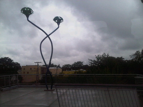
Lents Hybrids
The next stop along the Green Line is the Lents Town Center / Foster MAX station, home to Lents Hybrids:
Brian Borrello's Lents Hybrids is a series of spiraling plant forms with "buds" that generate energy through a hybrid system of wind and solar generators. The pieces are evocative of the native long grasses that may have once grown near the station area, while the buds are symbolic of the unfolding beauty and potential for the Lents neighborhood.
I only managed to capture one of the sets of hybrids while riding by on the train. There's at least one more at the station, with four spiraling stems instead of two. And I didn't do the two-stem one justice either, this being yet another crappy Blackberry photo taken from a moving MAX train.
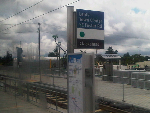
Borrello also created People's Bike Library of Portland in downtown Portland, Silicon Forest on the MAX Yellow Line, the blue ox feet at the Kenton MAX station, and apparently much, much more, including some giant filberts he's creating for the City of Tigard. Like Lents Hybrids, Silicon Forest is a collection of tall, skinny solar-powered tree structures. Add in More Everyday Sunshine and Nepenthes, and it starts to look like solar-powered art is a hot local trend right now. Or at least it will probably look that way to art historians a century from now.
Neighborhood Notes has a few construction photos. East PDX News has a few more, plus one of the finished product glowing blue at night, which looks kind of cool in a Lothlorien/Vegas sort of way. Lents Grown mentions a second artwork at the MAX station, Out of the Brambles by Wayne Chabre (who also created Connections at the Multnomah County building on Hawthorne). It looks like I would've needed to get off the train in order to see it, though, and even if I'd been in the mood to get off at each stop and look around, TriMet's website neglects to even mention that it's there.
As with Sky to Earth elsewhere on the Green Line, Lents Hybrids was created with help from a local pipe bending company. That sounds kind of esoteric, but their photo galleries showcasing their work are actually pretty interesting. Go take a look if you don't believe me.
Subscribe to:
Posts
(
Atom
)