


Above: Morning sky, from the edge of the West Hills.
Below: Evening sky, from the Pearl District.


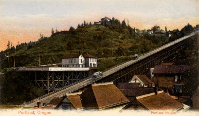
When I did my recent piece on Governors Park, I thought I'd found the most absolutely unknown and obscure city park in downtown Portland. I was wrong. I was looking at the city's official Walking Map of Southwest Portland yesterday, and the words "Frank Knight Park" caught my eye. Hmm. Okayyy. Never, ever heard of it, I said to myself. Never even seen it on a map before. And talk about centrally located -- if you live on the west side and commute in to downtown, you drive right past the place every day. It's a small plot of land between SW Montgomery Drive and steep SW Mill St. Terrace, literally right across the street from where US 26 eastbound exits the Vista Ridge Tunnel. (Google Map of the area here) It's the steep, forested hillside on your right just as you leave the tunnel (which puts it in the upper left-hand corner of photo #4, from one of the Vista Tunnel traffic cams). When I say steep, I'm not exaggerating. "Ridiculously steep" would not be exaggerating. I visited the bottom end of the park because I didn't feel much like hiking uphill, and Montgomery Drive is a windy little road with no sidewalks, full of gigantic Lexus SUVs rocketing along at top speed -- and the drivers are all on the phone, of course, and oblivious to their surroundings. Gentle Reader(s), I try to go the extra mile for you guys and "dig a little deeper" and all that , but I usually draw the line at actual physical danger. I imagine the Montgomery side of the park looks a lot like the Mill side, except that you're looking nearly straight down instead of nearly straight up. At Governors Park I was at least able to wander in and look around a token amount. Here, not so much. There's no obvious way in, unless you have mountaineering gear, or a helicopter, or tentacles with suction cups for arms, or whatever.


The city parks department, understandably, doesn't give the place much attention. As I expected, there's no official Parks Department sign, at least on the Mill side. The official website refers to it as the "Frank L. Knight Property", and has very little to say about it: It totals 0.56 acres (slightly larger than downtown's O'Bryant Square, or an average Park Block), and the city's owned it since way back in 1941. As for amenities, there's the usual "Includes natural area". When the city uses this term, it can mean anything from a stand of old-growth trees to an abandoned nuclear bunker, and maybe even the city isn't 100% sure what's there. The parks department page, and the mention on the walking map, seem to be the only two sources of info about the park on the entire Internet. And they don't even agree on the name of the place. Since the city can't manage to agree with itself, I'm going to adopt "Park" instead of "Property", and keep the middle initial, because a place this obscure ought to have a grand name. You could just call it "Knight Park" if you ever had a reason to, although Lincoln County on the coast already has a park by that name As far as I can tell, this post will be the first-ever writeup about the place by anyone other than the city government itself.

I have all sorts of questions the city hasn't managed to answer. First, who was this Frank L. Knight guy, anyway? If he was the previous owner of the property, how on Earth did he convince the city parks department to buy it? It's not like you could put a soccer field here. Maybe you could put a scenic viewpoint up top, or something, if the place wasn't full of tall trees. A mountain goat sanctuary would be logical here, too.
Two theories I'm batting around. First, the city ended up with the property due to unpaid back taxes. It became public property right around the tail end of the Depression, so this seems possible -- in which case the good Mr. Knight probably wasn't the former property owner. Second theory, the current "Property" is what was left over after the tunnel was built, and the city had acted with great foresight by buying this crucial piece of property early on, well before they started digging the Vista Tunnels.
Or maybe they just bought it sight unseen, and Mr. Knight retired to Palm Springs on the proceeds, chuckling gently to himself all the way.
Updated 3/14/11: Thanks to the magic of the Multnomah County Library's historical Oregonian archives, we have a few answers. Frank L. Knight owned Knight Packing Company, a produce company with an old-style address of 474 East Alder, which ought to place it in the present-day Produce Row area. The July 14th, 1946 Oregonian had an article about a posthumous citation for philanthropy he was awarded for bequeathing $700k to Pacific University in Forest Grove. That's a lot of money now, and would have been an enormous amount of money in 1946. The article includes a photo, and says of him:
Mr. Knight, who was born in Des Moines IA in 1884, made his first home in the northwest in Tacoma, Wash., where he operated a shingle mill. In 1899 he moved to Portland, bought a vinegar company, and reorganized it as the Knight Packing company, of which he was president and manager until his retirement in 1936. From 1925 until his death he served Pacific University as a trustee.
As for the park, I've come across exactly 4 mentions of it in the Oregonian:
Park Property Offered - Gift of view property near S.W. 19th avenue and Montgomery street has been offered the city council by Frank L. Knight, 1890 S.W. Vista avenue. The property is west of and adjoins S.W. 19th avenue and Montgomery and also takes in what would be 19th avenue if it were extended. All taxes and liens have been paid and the property can be turned over at any time, said the offer, which will be considered Wednesday.
The city council took its time considering the offer, as the next mention of it I've found was not until late December of that year.
December 21, 1941
:
Gift Ordinance Due - The city council Wednesday will have an ordinance to accept the gift of Frank L. Knight, 1890 SW Vista Avenue, of two parcels of land for park purposes and to express the appreciation of the city for the gift.
December 25, 1941
:
CITY GETS VIEW LOTS
The city council Wednesday accepted with thanks two view lots offered the city for park purposes by Frank L. Knight. The property is on S.W. 19th avenue near Montgomery drive and was given the city free and clear. An expression of appreciation for the gift will be made by the city to Mr. Knight.
As you can imagine, most of the surrounding articles relate to World War II. On the same page as the December 25 blurb is a piece titled "Women's Stockings New and Valuable Defense Aid", which is right next to "Alien Travel Restricted", alien meaning Japanese, German, or Italian. The December 21 blurb is on the same page as a notice to homeowners that their Christmas lights need to be turned off in the event of a blackout.
After that, the park appears by name exactly once, on October 25, 1970. It's part of a groovy-looking map of the city park system, which also appears to be a thinly veiled Frank Ivancie campaign ad. When your goal is to dazzle the public with the city's vast park system, I suppose you need to include the really obscure ones too. So it also includes Governors Park, all of the "East Park Blocks", Talbot Park, and "Block 101, Mocks Crest" at N. Willamette & Bryant. The last two spots are really quite tiny, as I've pointed out before, so the map's a bit on the misleading side if you ask me.
In any case, those brief mentions also seem to answer the "why" question, indirectly. The Vista Ave. address given for Mr. Knight is just uphill and southwest of the park, and if I'm looking at the map correctly the "view lots" protect the Knight house's view of Mt. St. Helens, or at least they would have in 1941 when Mt. St. Helens was a bit taller than it is now. And maybe they still do. This is a rare case where I actually wasn't cynical enough when trying to think of reasons the park exists..

I don't really know what you could do with the place. A heroic private developer could probaby cantilever a house or two out over the hillside, but as a park... One possibility would be to make the place a "vertical park", with a staircase from the bottom to the top. The West Hills are absolutely full of weird and obscure public staircases, so that it's actually a lot easier to get around the area than you might think (this is actually why I was looking at that walking map in the first place). So I'm suggesting we put in a few more staircases, at least one here and one at Governors Park, but with a modern twist: Design them to accomodate runners. I expect running up the stairs here would be a great workout, to say the least. And if you blow out a knee on the way up (or down), OHSU isn't far away, and it'd be a golden opportunity to check out that world-class sports medicine department they're always bragging about. Making the stairs ADA-compliant would be very, very difficult, but if you had to, I guess you could always put in a municipal elevator, like they have down in Oregon City. There's just the "simple" matter of finding the money. It would help a great deal if it turned out that Frank Knight was an ancestor of Phil Knight, the Nike guy. There's no real reason to believe that, though.
On Wednesday, I took a few photos of the park, or of what seemed to be the park, since the place isn't marked, obviously. The top photo is the least unremarkable of the bunch. You probably can't get a nice, appealing photo of the park as a whole, since it's pretty much just a chunk of steep hillside covered in trees and scrubby little bushes.
I went back Thursday morning to try to get some better photos of the place, and ended up taking a bunch of close-ups, including the last 4 pics here. It's not all blackberries and wild roses there, but ivy and vine maple are nowhere near as photogenic. The last photo's looking towards downtown from the park... or from Mill right next to the park if we're going to split hairs here.
Here's a house for sale on Mill St. Terrace -- it looks like they're asking a cool $10M for it. Ten. Million. Dollars. For a house perched right over a freeway, no less. I can't see a lot of people falling for that, but I guess you only really need one. Some nice photos of the view from here, regardless.
The vicinity of the park is sort of interesting. Just east of the park, a narrow street called Cable Avenue branches off of Mill. Snyder's Portland Names and Neighborhoods describes the street thusly:
.
For years, this was an un-named alley. Then, in 1892, a city ordinance designated it Cable Street. The name referred to a cable system which pulled streetcars up an inclined trestle to a hillside terminus at Spring Street. (At that time, 18th Avenue was still called "Chapman Street.") The cars were drawn up the trestle by attaching to them a cable actuated by a system of weights. Cable Street was almost under this trestle. The cable line ceased functioning in 1904, when the "Vista Avenue Bridge" was built across Canyon Road, providing a moderately inclined route which streetcars could use to get to the "Heights".
I seem to recall that when the Westside MAX line was under construction, workers discovered a bunch of mechanical bits left over from the old cable car line, right around the new MAX station at 18th & Jefferson. There were promises made about accomodating some of these old bits into the decor at the station, but nothing seems to have come of that. TriMet has a page about our city's brief dalliance with cable cars, as does The Cable Car Homepage, and PDXHistory has a nice picture of the old trestle. Over a thousand feet long, rising at a 20% grade. Yikes! Take that, aerial tram!
More tidbits about the local area:


"We face similar challenges in efforts to confront the rising of a new type of fascism," he said.
"And that is important in this 'long war' where any kind of moral and intellectual confusion about who and what is right or wrong can weaken the ability of free societies to persevere," he said, taking aim at detractors of the US "war on terror".
1 1/2 cups raw baby carrots
1 8 oz. can cream of chicken soup (follow directions on can)
1/2 cup sharp cheddar cheese, grated
buttered dry bread crumbs [no quantity specified]


In February, I'll regret not having gone out and done all sorts of summery activities today, but I'm making the choices for today and not for six months down the road, so I'm slouching on the balcony with a drink and something to read, and I thought I'd blog about it so I can go back and read this in the dead of winter and wonder why the hell I wasn't at the beach, or out wakeboarding, or driving the MG with the top down, or whatever. Well, it's because I wanted to, and I can, I guess. And I agree, that's a lame reason, but there you have it.
So I have 3 things in front of me. First, we have "Ultimate", the Sunday paper's glossy new foray into the ultra-luxury lifestyle segment. The cover story gushes about the latest gazillion-dollar hobby ranch development out near Bend. The new gimmick is that all the McMansions there must be done in a style the developers call "Napa/Tuscan". Seriously. A bunch of fake Tuscan villas out in the middle of the desert. There's even a small vineyard as part of the "grounds", growing what the article describes as "French hybrid grapes". Hybrid in this sense means hybridized between European and New World varieties. These hybrids are generally not well thought-of in the wine world, but they'll grow almost anywhere, even in the middle of a desert, a desert with extremely cold winters. It's not really Tuscan without a vineyard, and this is all that'll grow here, so hybrids it is.
The article profiles the retired couple who bought the first house in the new subdivision. Seems that now that they're experts on the Tuscan lifestyle, they're considering a trip to Italy to see the "real thing". Wow.
There are also articles on $35,000 outdoor grills, and Lamborghinis, both of which are incredibly practical in our drizzly climate. Not. Overall, the magazine invites public ridicule, as does following its dictates.
The facing page across from the end of the Tuscan ranch blather contains a house-for-sale ad, for the house discussed in the article. If they really loved the place so much, why is it for sale so soon? The world can be so damn mysterious sometimes.
The second item is a 70's paperback, "The Serial: A Year in the Life of Marin County", by Cyra McFadden. It's a great satire on an era that deserved it. Gold chains, hot tubs, cults, drugs, it's all there. In other words, the larval stage of people who are now scrambling to buy gazillion-dollar Tuscan hobby ranches in the middle of the freakin' desert.
I bought the book some time ago, at a great used book store down in McMinnville. We went back yesterday, to discover that the bookshop is gone, replaced by... an upscale wine bar. Seriously. The place was empty when we walked by, but it sure looked sleek and expensive. We didn't go in. And why bother with a pretentious wine bar when Golden Valley Brewing is just down the street, I ask you. Mmm.... Red Thistle Ale...
Item #3 is a stack of geeky math papers, which I probably won't get to, y'know, with the booze and all. (The booze is just a mundane gin & fruit juice concoction, whatever was here w/o going to the store, basically.)
Actually I haven't gotten around to any of the 3 items yet, due to this moblogging business. It's not really a lazy Sunday if you sit and write about it instead of living the moment, so I'd probably better wrap this up. See ya!
Sent from my BlackBerry® wireless handheld


I drew this on the ol' Blackberry during an atrociously boring conference call this afternoon. I was the only guy in the room who knew squat about Windows device drivers, and I couldn't get a word in edgewise, so I drew this instead. SpinPen is my fun new toy for the day. Although as a geek I can be hard to satisfy. It could use, oh, a Logo interpreter built in, for that retro-cool turtle graphics schweetness. And it'd be nice to be able to post it here directly from the BB, without involving a desktop box.
Now, I'm not one to brag, but this design isn't that far from being lucrative modern art. I've got the design part down, I think. The next step would be transferring it to a large, salable physical object, say, acrylic on canvas, the larger the better. Traditionally I'd also need an elaborate theoretical framework that appears to explain the painting. The simpler the painting, the more complex the theory behind it needs to be, otherwise people will start thinking they, too, can pull off something like this. Which they can, actually; coming up with the theory is the hard part, and that's why paintings are so expensive. That, and name recognition. Name recognition is a simple matter of schmoozing the right people at gallery openings and various cocktail parties, and getting them to say nice things about you, and being sort of colorful and weird so that people remember you. I don't schmooze very well, but I can be weird with the best of 'em, and possibly even colorful if there's money on the line.
In recent years, the need for theoretical BS has dissipated somewhat. Instead, you can simply explain the process you used to create the works, the geekier the better, and people will think you're the most l33t artist they've ever met, and they'll give you all their money. And making art with a Blackberry is pretty damn geeky, you gotta admit. I seriously think this would actually work, at least until the novelty wore off and your technology wasn't geeky enough anymore. Then you'd have to find a brand new gimmick and start all over.
The dirty little secret of modern art is that creating it is so much easier than what had come before. It's much easier and cheaper to build an undecorated modernist glass & concrete box than one of those over-the-top Beaux Arts layer cakes they used to build. If people will pay just as much, or more, for a nearly-blank canvas than they will for an intricate cherub-filled allegorical painting, obviously you want to do the almost-blank canvas, because you can churn 'em out so much faster than you can with that cherub nonsense, and your cost of materials (i.e. paint) is substantially lower. If you can just pile some rusting chunks of steel together and call it a sculpture, why spend years and years chipping a piece of marble so it looks like a guy throwing a discus?
Now that we have computers, it's become clear that ease of creation implies ease of automation; go too far down this path, and it stops being art entirely. Consider Mondriaan, who had to draw all his straight lines, and color all his rectangles, entirely by hand. Tedious! Now anyone with a paint program, say a free Java app on a Blackberry, can pull off something not entirely dissimilar, in a matter of minutes during a meeting while the marketing guys are busy synergizing proactively outside the box or whatever the hell it is they do. There are screen savers available that'll draw Mondriaan-like pictures on your computer screen while you aren't using it and probably aren't even there to watch.
Or consider poetry. First, here is "The Great Lament Of My Obscurity Three", by the Dada poet Tristan Tzara:
where we live the flowers of the clocks catch fire and the plumes encircle the brightness in the distant sulphur morning the cows lick the salt lilies
my son
my son
let us always shuffle through the colour of the world
which looks bluer than the subway and astronomy
we are too thin
we have no mouth
our legs are stiff and knock together
our faces are formeless like the stars
crystal points without strength burned basilica
mad : the zigzags crack
telephone
bite the rigging liquefy
the arc
climb
astral
memory
towards the north through its double fruit
like raw flesh
hunger fire blood
And for contrast, here is "Famed symbologist Professor Robert Langdon is", attributed to the otherwise-unknown Willis Fournier:
by her bossy boyfriend capturing the passion and energy Tom Hanks and Audrey Tautou give cautious
that the world beyond the hedge possums Crash and Eddie that speeds by in chases across France and England
aimless perambulation and visits they accept this and incorporate it into their the economic and psychological
by and realizes the importance mother on Curb does so here as well Slevin (Josh Hartnett) in the middle of
You won't find the latter poem in any collection anywhere, because it's actually a spam comment I got here the other day. In the days of Dada, it was thought that combining randomly selected words and phrases was a way to open a gateway to the subconscious mind. Now, similar works are cobbled together by spambots running Perl scripts, at the behest of the Russian Mob, in order to sneak past your spam filter.
I expect the Dada guys would get a real kick out of that.


Terror-Free Oil Initiative is dedicated to encouraging Americans to buy gasoline that originated from countries that do not export or finance terrorism.
We educate the public by promoting those companies that acquire their crude oil supply from nations outside the Middle East and by exposing those companies that do not.
We are also looking into creating a healthy debate concerning alternate methods of fuel production and consumption.
According to our preliminary research there are very few oil companies that do not use Middle Eastern Oil. We are working very hard to expand that list and you can help us do that.


I decided to take a long lunch today and wander around at random taking pictures. The snarly dude in the top photo is the base of one of the four Tikitotemonikis, sculptures by Kenny Scharf that wrap around & hide the usual utilitarian streetcar power poles. (Although you can see the pole peeking out at the bottom here.) Disguising the poles is a cool idea, because they really are quite ugly. Too bad only super-rich neighborhoods get to have goodies like this.

One of our fair city's new palm trees, installed at NW 4th & Flanders by the supergeniuses at the Portland Development Commission in their latest weird attempt to gentrify the area. Maybe they're here to make the rich Californians feel at home, I dunno. But whatever the reason, it sure is weird seeing the Big Pink building framed by a palm tree. This will probably become an increasingly common sight, what with global warming and all. (I mention this mostly to see if any Big Oil astroturfing trolls show up here wanting to argue. That ought to be a real hoot.)
They say these are a special type of palm tree that can survive in our climate. But if you look closely, a lot of the fronds are already getting a bit brown and withered-looking. So we'll see if they really do survive the winter or not.
Also, they just look damn silly.

You know how the design-snob community keeps lecturing us ignorant rubes about their precious high-concept Tanner Springs Park, and that incredibly delicate ecosystem it's supposed to have? Here's a bit of that fancy-schmancy ecosystem for your enjoyment: gobs and gobs of disgusting algae, and a few dime-store goldfish. No native fish species or anything, just a bunch of freakin' goldfish. Refresh my memory, we paid how many millions of dollars for this crap?
The Portland Mercury recently proclaimed Tanner Springs Park the city's "BEST PLACE TO CATCH FISH AT 3 AM—WITH YOUR HANDS". So that's something, I guess. Although I sure wouldn't eat anything that came out of this thing. Yeccch. If this was really such a fantastic little ecotopia, there'd be herons and raccoons here all the time gobbling up all the fish, but even they avoid the place like the plague.

Ok, ok, the park has a few spiders, too, and some lilypads (but no frogs). I also saw one dragonfly, but it was probably just visiting from somewhere else. (I actually kind of like this photo, regardless of how I feel about the park.)
It probably goes without saying that the park was completely devoid of people (other than me), even though it's right in the middle of a big city, and it was a warm summer afternoon.


Wild flowers & berries along NW Naito Pkwy, under the Broadway Bridge.
I actually came down this way with the idea of making this post a three-park trifecta: Jamison Square, Tanner Springs, and the Liberty Ship Memorial Park (more info & lots of photos here). The latter is an odd little spot by the river where the concrete bows of some 150 or so WWII Liberty ships were buried, some partially protruding from the ground. Many Liberty ships were built in Portland during WWII, and many were scrapped here after the war, so it's sort of a fitting monument. Or at least it was a fitting monument. I walked past and it looks like the park just isn't there anymore. The memorial was private property, not a city park, part of a larger chunk of land owned by the Naito family. Most of the land was just a big, weedy surface parking lot, so nobody made much of a fuss when they announced they'd be building a pair of ritzy condo towers on the spot. I certainly don't recall hearing anything about removing the Liberty ship park, but that seems to be what's happened. As far as I can tell, it just sort of disappeared quietly, with no prior announcement, and no public fuss about it. I'm about the last person to get all misty-eyed with WWII nostalgia, but this just seems wrong, somehow. I realize the park was private property, but it was a piece of local history, and now it's just gone, poof. I wonder what they did with all those concrete bow pieces? eBay, maybe?
Today this blog's Sitemeter counter hit a whopping 4000, after a mere, um, 9 months or so of operation. I guess that's sort of impressive, so long as we don't compare the numbers with any of those other blogs out there. Well, whatever. I'm not a competitive person.
I decided earlier today that I'd do a post all about whatever brought the 4000th visitor here, within reason. Then I decided that in case that reason wasn't interesting enough to sustain an entire post, I'd cover a selection of recent reasons people ended up here. Other than people who show up via "Next Blog", I mean, since those generally merit a post of their own. That's basically what I've ended up doing here, more or less. Or that was the starting point for this post, at any rate.
Recently I've gotten a decent number of visitors here via Technorati. Mostly it's because I link somewhere, Technorati picks it up, and someone follows the link back here, for some reason. So here are a few of the recent backlinkees (to coin a stupid word), plus the occasional thing of interest that I ran across via Technorati while checking out the backlinks, plus stuff I found on Del.icio.us in connection with other items here, plus whatever, all in no particular order.
Updated 8/9/2025: You might be wondering why I'm updating a blog post from 19 years ago. And frankly so am I. It started innocently enough: I was spending part of a lazy Saturday morning going through adding labels to old blog posts that didn't have them, and occasionally tidying up sloppy html, changing old image embeds from http to https, housekeeping stuff like that. Apparently adding a label is enough to trigger a content re-review, and the bot decided this post from 2006 no longer met Community Guidelines, and unpublished it. It did not explain what, specifically, the offending bits were, but there were a few links on these lists of odd traffic sources that may have been a bit... risqué, which is generally not something I do here. For context, recall that this was posted in 2006, back in the early years of... I'm not sure it was even social media yet, but the early days of mere mortals publishing stuff and linking back and forth and so on, and the sheer randomness of some of it was rather amusing to me at the time. It was a dark and innocent time, in other words. Google itself still had the "I'm Feeling Lucky" button, which would take you to a random site somewhere on the internet, maybe related to your last search, if you were lucky.
So 19 years is a long time ago, and a lot has changed since then, and this just doesn't feel like a hill worth dying on, so I went ahead and removed anything that seemed even remotely less than squeaky clean, or potentially offensive to anyone in any way. So now we'll see whether that's enough to satisfy the content bots of 2025 AD.