Saturday, July 09, 2011
Friday, July 08, 2011
Rippling Waters Park expedition
View Larger Map
Today's thrilling adventure takes us out to little-known Rippling Waters Park along Gales Creek in western Washington County. Those of you who are, inexplicably, long-time readers might remember me mentioning this place twice before; for the rest of you, a brief recap. Washington County doesn't have an extensive county park system; there's Hagg Lake south of Forest Grove, little Metzger Park near the Washington Square Mall, and this place, which almost nobody has ever heard of. It seems that the county itself forgot about the place for several decades, and when they finally realized they owned it, they promptly put up the big scary No Trespassing sign you see here. There wasn't (and still isn't) money in the budget to operate it on an official basis, and they can't ignore people using it on a less than official basis because then someone would inevitably get hurt and sue for big bucks. The only approved visitors seem to be occasional groups of volunteers, pulling up invasive plants and taking water quality samples and so forth. And, unofficially, it seems the place has always been a traditional local fishing and swimming hole.
So you might have noticed I didn't get very far on this so-called expedition. I didn't even pass the No Trespassing sign, since I wasn't sure how strictly that was enforced. I wasn't in the mood to get tasered that day, or to get tasered later after posting photos on the net, or for that matter to get sued after someone else saw the photos on the net, went to the park, and got tasered. So there's that. I mean, if I thought there was something really amazing I needed to see past the sign I would've considered it. But some underbrush and a creek? Nah.
Also, I was on my way back from a quick day trip to the coast (including a visit to Munson Creek Falls), and I was running a bit behind schedule (and about to get stuck in Portland weekday rush hour, as it turns out), so even if there was an unexplored Egyptian tomb just up the trail I still might have left it for another day.
The point (at least this time around) was simply to find the place and take a token photo or two so I could reasonably do a post about it. I was intrigued by the park, or at least the idea of the park, when I read those 1999 Oregonian stories about the place. I was fascinated that a chunk of land this size, ostensibly a public park, could simply fall off the county's radar and be forgotten for decades. It's fair to say that, in a roundabout sort of way, this eventually led to this humble blog's ongoing park project, for good or ill.
I checked the Oregonian historical database for earlier mentions of the park, and there are a few starting back in the 1920s. The articles suggest that the park had already been around for a while when it first appeared in the Oregonian. My guess is the Portland paper started mentioning the place around the time its readers started buying cars and it became possible to visit the park on a day trip from the city. As a caveat, I'm not absolutely certain these early mentions are about today's Rippling Waters Park. The park in those days seems to have been privately owned, and offered swimming and group picnic facilities (numerous mentions of the place were in relation to company picnics, school reunions, etc. being held there), and even overnight cabins. I realize I didn't venture very far into the park, but I didn't see any of that stuff, or any obvious evidence it had once existed. So maybe it was the same park (or a portion of it) and nature's thoroughly claimed it back over the last century, or maybe it was another place by the same name in the same general vicinity. I can't rule that out since I ran across quite a few midcentury real estate listings advertising that they were in the Rippling Waters area. In any case, that early period came to an end in the 1940s. This notice appeared in the July 13, 1941 Oregonian:
RIPPLING WATERS PARK -- Famous park on Gales Creek, Wilson River road, 16 a. [acres?] picnic, swim, cabins. Must be sold. Take Portland or sub. home as part. LYMAN ROSS, ALOHA OR Excl. agent
Additional sale notices appeared over the next couple of years, and then the park basically dropped off the Oregonian's radar until 1985, at which point it was a poorly-maintained county park. Neighbors complained to the county about unruly teen parties (which, given the year, could easily have included classmates of mine) and even occasional gunfire, and the county briefly considered what to do about the place. A couple of typical stories from that era:
- July 10, 1985 article "Complaints bring county steps to limit park use"
- June 6, 1985: Park status asked for Rippling Waters trail
I didn't go through and read all of the 1985 stories, since it's quite obvious that if they made any grand plans for the park, they didn't follow through on them. Chances are they punted on the idea when they realized it might cost money. The big scary Keep Out signs may have come later, during the even briefer 1999 handwringing episode about the park.
So I realize there are pretty big gaps in the story. We don't know when the place started, and we don't know when or how the county ended up with it, assuming it's the same park. I imagine we'd have a much clearer picture if only there was an online database for the Forest Grove newspaper, or even the Hillsboro one, but as far as I know neither of those is currently available. So feel free to leave a comment if you happen to know anything more about the place, or you have fond (if vague) memories of those wild 1985 keg parties you'd like to share, or you'd just like to cuss me out for telling the entire internet about your local secret swimming hole. I suppose that would be only fair, although I've been telling the internet about all kinds of local secret spots for years now, and I've never once been important enough for anyone to even notice, much less care.
Thursday, July 07, 2011
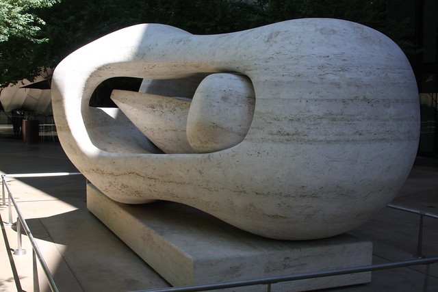
Reclining Connected Forms
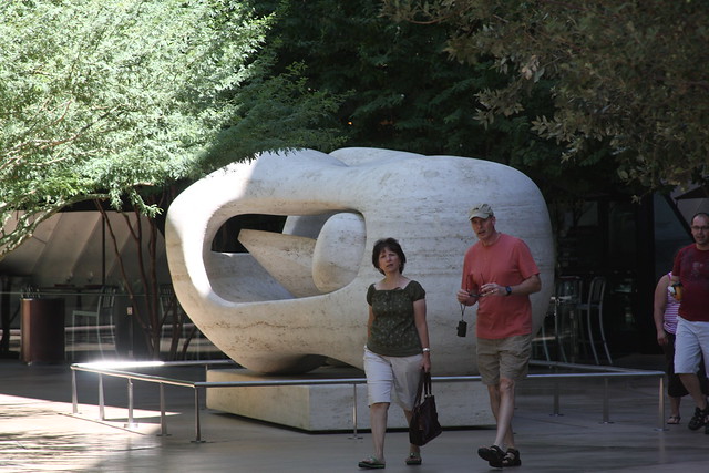
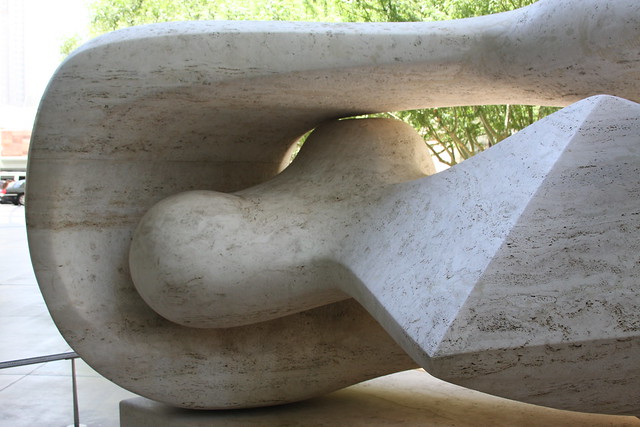
The occasional tour of Vegas highbrow art continues, with a visit to Reclining Connected Forms (1969-1974), by the English sculptor Henry Moore. Like Typewriter Eraser Scale X and Big Edge, it's part of the $40 million art collection at the $10 billion CityCenter complex, and can be found tucked away between the swanky Crystals mall and the alarming Veer condo towers.
As a headline art attraction at a shiny new casino, there are more than a few mentions of it on the net, so I'll just pass a few along that seemed interesting. An About.com piece about it includes a photo of it in a gallery, prior to its arrival in Vegas, and it's mentioned in a funny article about CityCenter art at VegasMavens. And a cardboard spoof version of it appeared in a recent show titled CountyCenter.
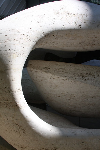
The date given above spans the years 1969-1974 because this is just one in a series, and it has siblings of various sizes & materials scattered across the globe. Sightings of various siblings I've come across on the interwebs:
- Smaller bronze predecessor at Adelaide University in Australia.
- In Kansas City at the Nelson-Atkins Museum of Art
- Storm King Art Center in upstate New York
- The Museum of Art in Fort Lauderdale
- Kew Gardens in London
- Trinity College, Dublin
- On the grounds of the Henry Moore Foundation itself.
- One was sold at auction by Sothebys earlier this year. I didn't create an account to see exactly how much it sold for, but the page says the pre-auction estimate was around £1.5M to £2.5M, and says it's number 5 of 9 copies produced.
- A much smaller maquette for Reclining Connected Forms, 1969 sold in 2010, with an estimated price of £35k-£45k.
- In 2006, a bronze version was removed from display at Exeter University (UK) due to fears about metal thieves, and returned to the Henry Moore foundation. So it might be the same one mentioned above, or possibly the foundation has multiple copies and one's the designated loaner.

Eagle Creek Bridge
View Larger Map
A few photos of the old Columbia River Highway bridge over Eagle Creek, in the Columbia Gorge. It's part of a short surviving segment of the old highway and now serves as part of the freeway offramp from I-84. I took these as an afterthought while visiting nearby Ruckel Creek Falls, and I later decided there might be a bridge post in it. It's kind of a cute little bridge, after all.
Some info about the bridge at Structurae and Oregon Hikers Field Guide. The Eagle Creek page at Columbia River Images includes several photos and old postcard images of the bridge, so that's worth a look too.
The Oregon state archives offers an online version of the 1940 travel guide Oregon: End of the Trail, which was produced by the Federal Writers' Project (a cool New Deal program you'd never get through Congress in this day and age). They've broken the book up into segments that follow the main highways of the day, and the Eagle Creek to Portland segment includes a few interesting photos from Eagle Creek and the west end of the Gorge. Incidentally the main highway at that time was US 30, the wider, flatter, river-level road built to replace the original Gorge Highway. US 30 evolved into today's I-84, so unlike the original highway there aren't a lot of visible reminders of old US 30 that survived to the present day. People tend to forget that we didn't jump directly from the 1914 road to an interstate freeway. And the original highway, picturesque as it was, was already considered obsolete shortly after it was created.
While we're splitting hairs, the old highway wasn't actually the original road through the Gorge; that honor goes to the earlier Dalles and Sandy Wagon Road, a few precarious segments of which also survive. It would be interesting to see that, but my understanding is that visiting the Shellrock Mountain segment involves pulling over & parking on the narrow shoulder of I-84 just around a blind corner, which I don't think I'd be willing to do. So it's nice to see that someone else did it already and put photos on the interwebs.
Prior to the wagon road, the only way to pass through the Gorge was by boat, which was reportedly quite a dangerous way to go. If you've ever played the classic Apple ][ game Oregon Trail (not that I'm of a certain age or anything), you might recall that at The Dalles you have to choose whether to take a raft down the river (and inevitably drown, in my experience), or take the Barlow Road over the mountains (which is occasionally survivable). Here's a history page describing what those two options were like in real life, if you aren't inclined to rely on 1970s video games as historical documents.
In winter the water route became impassable whenever the river froze over, which apparently happened regularly in the 19th Century. The December 13, 1873 Dalles Chronicle described the difficulties in an article titled Ice Holds Trade in Death Grip. The article waxes on about how great it would be if there was a wagon road to Portland. It also mentions a couple of other ideas that were also implemented, like putting in a railroad to Portland, and building locks at the Cascades downstream of the Dalles (at today's, uh, Cascade Locks).
And, of course, before the Oregon Trail there would have been Indian trails through the Gorge dating back thousands of years. Pioneer history buffs tend to ignore that part. Which may be one reason I just can't get too excited about pioneer-era history, come to think of it.
Saturday, July 02, 2011
papyrus
A few photos of papyrus plants at the Honolulu Zoo. I don't recall ever seeing papyrus plants before (at least not labeled as such), so I took a few photos. Not overly fabulous photos, I guess, but it's kind of an interesting plant so I figured there was a minor blog post to be had here. And it just wouldn't seem right to do a post on papyrus plants without including a token bit of writing, which is what you're reading now. And since there's a bit of writing anyway, why not use the Papyrus typeface for this post? I mean, it's an ugly cartoonish typeface, but it seems semi-appropriate somehow.
Friday, July 01, 2011
carwash
This is just a video voyage through a carwash, taken earlier today. I kind of like the abstract quality the clip has, plus I've been procrastinating about washing the car for months now, so I'm kind of saying "Hey, look what I just did" by posting this, as unimpressive a feat as it might be. In my defense, there's really no point in washing a car while we're getting an inch of rain every day, which is most of the year. Furthermore, I also don't drive a lot, and I only remember how dirty the car is when I'm driving and trying to see out the windshield. Also, driving a clean shiny car is simply not the way of software engineers. It would be like wearing a suit to work or something. In short, the whole carwash thing is almost certainly a much bigger deal to me than it is to any of you out there.
Since you're here already, let me direct your attention to the Wikipedia article for "Car Wash", which includes a bit of history and explains briefly how automatic car washes work. For more gory details, there's a rather comprehensive HowStuffWorks article that explains the whole process in depth, with lots of photos. In case you've ever wondered what all the stuff spraying and flapping around is for, I mean. Oh, and here's a History Channel video with some vintage video clips and so forth. It's only about six minutes long, so I guess the History Channel just didn't have time to explain how car wash technology is connected to Hitler, UFOs, and Bigfoot. If they don't already have a multi-hour special on the topic, it's probably only a matter of time.
Anyway, the car's clean now. So now let's sit back and watch it rain nonstop for a few months.
Thursday, June 30, 2011
Wednesday, June 29, 2011
the portland, honolulu
Couple of photos of Honolulu's Portland Building. The name surprises me, and I've yet to determine whether it refers to our Portland, or to some other place, company, person, or thing. A survey of historic buildings of Hawaii mentions it briefly (all typos are theirs):
Portland Building -Constructed in 1903 at South Hotel and Union Mall in Honolulu, in the architectural style of the the Portland Building is the Late Victorian period.
Oregon has a handful of Hawaiian place names, including the Portland suburb of Aloha, and the Owyhee River in the far SE corner of the state. So I suppose it's not unreasonable to have something in Hawaii named after something in Oregon. Still seems peculiar, though.


