Thursday, September 13, 2007

Somewhere Near Dalton Falls

Dalton Falls


View Larger Map

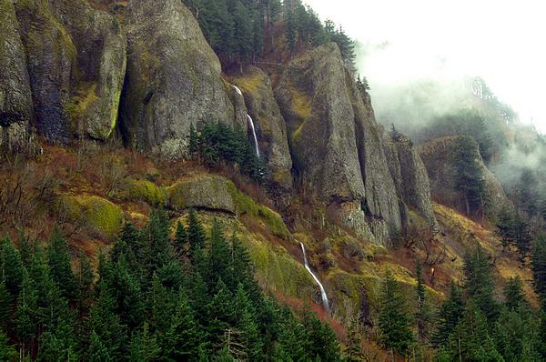
Today's scenic adventure takes us to Dalton Falls, out in the Columbia Gorge yet again [map]. Or at least I think this is Dalton Falls. I could be wrong. It's a highly obscure waterfall that doesn't show up on most maps, and there's no road sign announcing it, even though its base is almost right next to the scenic highway. Oh, and did I mention the falls dry up in the summer? Thus driving out to go search for them isn't foolproof either. In short, what you're reading is what I've been able to piece together and deduce so far. Think of it as a progress report. I'm pretty sure I found the right place, or at least the immediate vicinity of the right place, but I always strive for accuracy here and I'd hate to get the facts wrong. So all I'm claiming right now is that I was somewhere near the falls, and "near" is a very flexible word, you know.

The map link above takes you to WikiMapia this time instead of the usual Google Map. WikiMapia be the only map on the interwebs that gives even a rough idea of where the falls are, and the only reason WikiMapia has them is because I added them. I figured out the location with the slick USGS Topo maps at BackCountryMaps. The USGS maps indicate the falls are at "roughly" 45.57088383381129 latitude, -122.14350700378418 longitude. (I don't know how many of those digits are actually significant.) Before anyone complains, yes, the box on the map includes the parking lot, and the lower cascade, but the main falls are just outside the box. I fat-fingered the box when I drew it and now I can't figure out how to resize the damn thing.


Dalton Falls

So here's essentially all the useful info I found on the net about Dalton Falls, and there isn't much of it:

>
  • The page about Dalton Falls from the Northwest Waterfall Survey is the best source of info I've run across. I'd never even heard of them before running across this page.
  • Here's a fantastic photo of the falls. The same photographer has a large collection of nice waterfall photos here. I know I tend to apologize for the quality of photos here a lot. Sometimes I'm just being modest and I'm secretly kind of proud of them. But this time I really do have to apologize. How about we all agree today's photos serve a purely documentary purpose, since they aren't very artistic, or even all that visually interesting. And this is after going over them with GIMP, trying to mitigate various exposure and color issues and not always succeeding. You'd think it'd be really hard to take a third-rate photo of a frozen waterfall. In my defense, I'm pretty sure there was shivering involved. Taking a nice photo is great, but taking a mediocre photo really fast and getting back inside the warm toasty car is even better, or at least I was quite certain it was at the time.
  • A great page about the Gorge, which includes pics of some "unnamed seasonal waterfalls" in the Gorge. I think some of them are of Dalton Falls, or at least of the place I've rightly or wrongly concluded is Dalton Falls. Others are of Mist Falls, and the falls near the Vista House (which I've seen called "Crown Point Falls" before -- here for example -- although I think it's an unofficial name.)
  • The falls get a quick mention in this excerpt from the 1954 book History of Wasco County, Oregon, by William H. McNeal. McNeal raves on and on about the Gorge.


    SHEPHERD'S DELL [sic] was called "the playground of the fairies!" Bridal Veil Falls has no comparison! Coopey and Dalton Falls would be outstanding in any place as would Eagle's Rest! Waukeena Falls and Multnomah Falls are internationally known! Simon Benson gave them to the state as a park! Multnomah Falls is called "the Queen of all American cataracts;" its drop is 870 feet! Some say, "its too beautiful to be real," others say, "a dream garden falls".
  • OregonWaterfalls.net has a mislabelled photo that's actually of nearby Mist Falls. I'm sure it's Mist Falls, because I've been there, and this is what it looks like. The confusion is understandable, since both falls are very, very obscure, and are just down the road from one another.

Dalton Falls

There's a gravel parking area at the falls. There's no sign saying what the parking is for, so in the summer you tend to get curious people stopping to look around and getting confused. When the falls aren't running you have some high mossy cliffs next to the scenic highway and that's about it. In my Mist Falls piece, I mentioned there was a larger parking lot a short distance west of the tiny one at Mist Falls, and I didn't know what it was for at the time. Then I saw the Waterfalls Northwest piece, and went back through the archives and found a few instances where I took pics of the falls (I think) without knowing they had a name. Or at least, looking back, I'm pretty sure I took the photos in the general vicinity of Dalton Falls. It's been a while, and I could be wrong in a couple of cases. They basically look right, though, so if I'm wrong, I'm not all that wrong.

Dalton Falls

Getting there is like getting to Mist Falls. If you're going east and get to Wahkeena Falls (or Mist Falls for that matter, if you can recognize it), you've gone too far east. If you're going west and see the Angels Rest trailhead parking lot, you're too far east. There's some sort of silver box containing railroad equipment at the parking lot, across the street from where the falls are. I don't know how common these boxes are, there may be others all over as far as I know -- so regard this as a necessary but not sufficient condition for finding the place. I'm afraid I didn't get a pic of the parking lot this time, but you might not need one. Either the falls are flowing, in which case you ought to be able to see 'em from the road, or they aren't flowing, in which case there's really no reason to stop at all, that I'm aware of.

Dalton Falls

As far as I know, the parking lot only gets you access to the base of the falls, which is practically right next to the road. I haven't heard of of any trails going further uphill. If they exist they'd have to be quite steep and thrilling, since you'd likely be hiking them in the winter or spring while the falls are flowing.

Dalton Falls

Updated 1/9/2021: A couple of addenda to this very old post:

  • As I mentioned in a nearly-as-old post in 2008, Dalton Falls is also right next to the old highway's milepost 31 (the post includes a photo of the falls and the milepost, so there's no mistaking it.). So that ought to be a more specific clue than the ones I mentioned above.
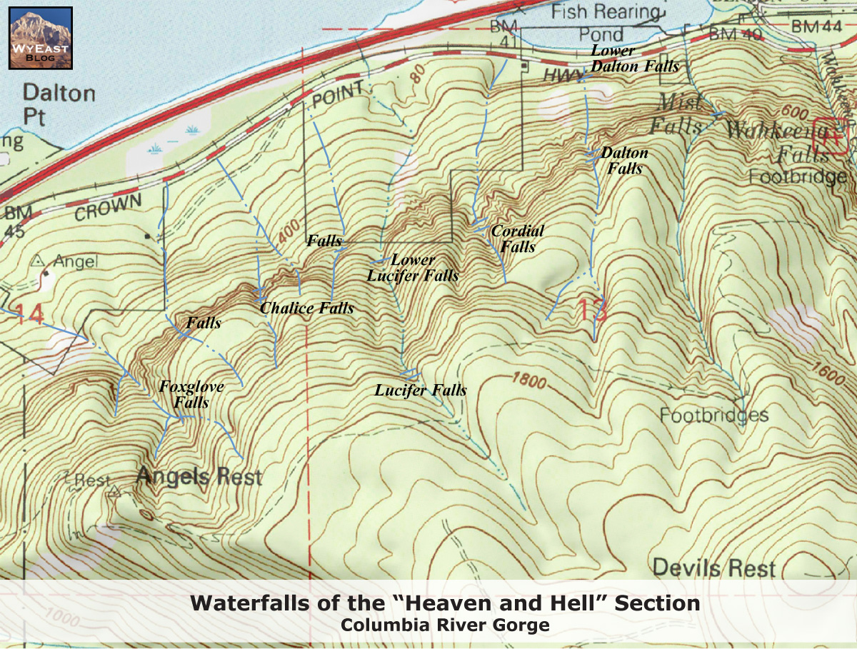
  • The Northwest Waterfall Survey page I mentioned earlier (link updated) now explains that the name "Dalton Falls" seems to have originally been applied to a different waterfall on the creek immediately east of Angels Rest, which has since picked up the unofficial name "Foxglove Falls", named after a couple of nearby trails. One possible clue in favor of this theory is that the alluvial fan from that creek extends out into the Columbia as Dalton Point, which we visited back in 2018.
  • Recreating the HCRH expands on that discussion at length and proposes calling the falls shown in this post "New Dalton Falls".
  • A March 2020 WyEast Blog post digs even further into this situation, and proposes names for all the other seasonal falls between Angels Rest and Wahkeena Falls (with included aerial photos of most of them), I guess on the theory that names don't hop around as much if there isn't a vacuum that seems to need filling. The author keeps Dalton Falls on the present-day creek, but splits it into two, Dalton Falls being the tall falls you can see from a distance, and Lower Dalton Falls being the shorter one right up next to the old highway.
  • Per the map from the previous item, I think the creek that's home to "Cordial Falls" (the next one west of Dalton) is the same one ODOT called "Mosquito Springs Creek" in a recent press release about a landslide. And west of there by a watershed or two, I think one of the more minor spots he just called "Falls" may be the canyoneering location known as "Devil's Whisper".
  • Complicating matters slightly more, there is actually an officially-named Dalton Creek nearby, but it's a minor tributary of Young Creek, which then flows northwest and forms the falls at Shepperds Dell. The USGS coordinates for the creek are due south of the east-of-Angels-Rest creek, so my personal theory is that a data entry error may have crept into the USGS database, either for the 1986 database entry or the 1964 state map it's based on. Just changing the latitude of the official 'source' coordinates from 45.525N to 45.565N moves that point to almost right on the rim of the watershed for that creek. On the other hand, the mysterious "W. Dalton" who's believed to be the namesake of all these places might have been enough of a local bigwig at the time that several unconnected places were named for him or her.
  • The naming situation is much clearer for the rocky overhang the falls go over, as it turns out this is a popular local rock climbing spot known as "The Rat Cave". So if you can't find the milepost for whatever reason, like maybe someone stole it to sell on eBay or something, but you do see the overhang, and there's climbing hardware attached to the underside of the overhang (like in this OregonHikers thread), that could be yet another a clue that you're in the right place.
Dalton Falls

Monday, September 10, 2007

...wherein I raid the archives again...

Not much to say about this collection. I was scratching my head about a weird bug, and switched over to rifling through old(ish) photos for a bit. I found a few I'd never posted but liked enough to post, so here they are, for good or ill. Some are old, others are recent, many are of old standbys -- which probably explains why they weren't posted before, I mean, how many Lovejoy Fountain photos do I really need, for example? The answer, apparently, is "more".

lovejoy fountain

Lovejoy Fountain

More Lovejoy Fountain, like I said. The first one's recent, taken with that wide-angle doodad I keep going on about. Oh, and did I mention it was a long exposure at night? The other one's from last fall, I think, taken without any add-ons or other gimmickry at all. Either I hadn't got into experimenting yet, or I just hadn't gotten jaded. Take your pick.

rusting chunks

My metallic nemesis, Rusting Chunks No. 5, this time done wide-angle style. This was taken from right in the middle of the thing. It's cramped quarters there, with no way to take a step back, so without the new widget there's no way I could've fit all this stuff in the frame. For whatever that's worth.

sun via sunroof

In a pinch, a car sunroof makes an interesting filter.

tanner springs

tanner springs

A couple more photos from Tanner Springs.

vera katz park

The future site of "Vera Katz Park", a fancy name for the little strip of land on the north side of the Armory Theater. It's a fitting name in many ways. It's a minor adjunct to the grand dreams of a well-connected developer, and it's been delayed greatly due to cost overruns and general mismanagement.

sun from stumptown

A photo of the sky from the Stumptown Coffee downtown. I'm not sure why I like this one, exactly, but I do.

sky

More sky, from somewhere downtown, probably. I don't recall anymore.


pearl alley

A narrow alley somewhere in the Pearl.

tanner springs marigold

tanner springs marigold

More Tanner Springs.

decaying plaster somewhere

A decaying plaster wall, somewhere in the Pearl, I think.

chimney fountain

Another pic of the Chimney Fountain.

Friday, September 07, 2007

photo friday, rattled edition

pink

So here are a few photos I took earlier today while I was wandering around Lake Oswego, wearing a suit and sipping some kind of fruity mango smoothie. That's all highly out of character for me, but I was on my way to a funeral and was pretty rattled about it, so I thought I'd stop and chill out for a bit.

Most of the flowers you see here are at George Rogers Park on the Willamette, and all the water & sculpture ones are at or near Millennium Plaza Park, right on the lake in downtown Lake Oswego. Well, "right on the lake" is a bit misleading. The lake itself (which is a reservoir, actually) has a unique legal status: It's privately owned, and lakefront property owners own shares in the company and pay dues to maintain the thing. If you aren't part of this elite club, no lake for you. You aren't supposed to even touch the water here. No doubt something unimaginably terrible and gruesome will happen to you if you do, more than likely involving an ancient Egyptian curse, or a radioactive monster, at the very least lawyers.

Quite frankly I didn't need any convincing to stay out of their precious lake. I'm told the thing stagnates and gets really icky algae problems in the summer (not that we've had much of a summer this year). I'm sure it's the better sort of algae, the ultra-upscale imported kind, not the tacky stuff they have at Blue Lake out toward Gresham. Or at least that's what the locals probably tell themselves over and over again, so that they don't feel they're getting a raw deal. I guess it's sort of the aquatic equivalent of a stinky French cheese, one that only a true connoisseur can appreciate.

duck

You might have gathered that I don't really feel like talking about the funeral itself. That shouldn't be surprising, as I've always said this isn't the most personal of personal blogs, and deliberately so. For the same reason, I'm not going to get overly detailed about why I've been heading out to the Columbia Gorge so much lately, but I will say it's been therapeutic. Oh, you thought I was doing all that just so I could blog about it? Well, no, no I wasn't, not exactly. Although the blogging part was kind of therapeutic as well.

berries

When you work in an obsessively casual industry like mine (software), you tend to forget how people react when you wear a suit, versus the usual shorts + t-shirt. I could probably have gotten away with just about anything (other than jumping in the lake). People see the suit and assume you're authorized to do whatever you're doing. I'm not sure why, certainly not after Enron, but a suit still grants you the benefit of the doubt. Mass quantities of benefit of the doubt. It depends a lot on where you are, though; just try walking down Mississippi Avenue in Brooks Brothers, or Men's Wearhouse for that matter. You might as well be wearing a Klan robe so far as the hipster contingent's concerned. They'll figure you're a greedy developer, trying to put in a condo tower or a Starbucks or something. They'll probably assume you drive a gigantic SUV that runs on kittens.

And they'd have a good point. The first couple of minutes when people start acting all deferential toward you it just seems weird. Then you realize it's the suit, and for another five minutes you feel like you've acquired magic powers of thought control, and it feels kind of good. Then -- at least if you're me -- you get alarmed by the whole idea. People will apparently do just about anything to make you happy, just because you're wearing the right clothes. It doesn't speak well for the human race, if you ask me.

The other, far less likely, possibility is that it had nothing to do with the suit. People were recognizing me, realizing I was an Important Local Blogger Of Note, and bowing and scraping because of that, hoping I'd put in a good word for them out here on the Interwebs.

As I said, far less likely.

gold

tubes

pink

pink

leaf

pink

red

buoy

sculpture

Wednesday, September 05, 2007

a new toy, and beer

Tugboat IPA

A few pics, mostly of beer, taken with a cheap wide angle converter I picked up at Fry's the other day. The thing's supposed to fit onto the front of your camera via a little adhesive-backed magnetic ring that sticks on around the lens. I haven't attached the ring yet, since I think I need to file it down in a couple spots so it doesn't block any light in the corners of the frame. So for now I'm just holding the adapter up to the lens with one hand, taking the photo with the other. Results so far are mixed, but interesting. I could probably get rid of the vignetting (the dark rounded-off corners) by zooming in a little, at the expense of some of that wide-angley goodness. On the other hand, the vignetted look's been kind of trendy of late. I don't know if it's due to the Holga craze or what, but you see it around quite a bit.

The main reason I got this new thingy is because the last couple of times I was out in the Columbia Gorge, there were times where it just wasn't possible to get the picture I wanted to take. I just couldn't fit everything into the frame, and taking a few steps back would've meant falling off a high cliff. Suffering for art is fine and all, but one has to draw the line somewhere, and I have a firm, longstanding anti-plummeting policy.

A $30 adapter is obviously no match for a "real" camera with a dedicated wide angle lens on it. Gentle Reader(s) of this humble blog might've noticed I've been doing a bit of handwringing about digital SLRs lately, and there's a reason for that. I keep going back and forth on whether I ought to get one, a process that's devolved into endless handwringing. My usual policy on gadget upgrades of any kind is that you only do it when you've hit the wall with your existing gear, and there are things you simply can't do to your satisfaction. Not because you think swanky new widgetry will be the magic dust that makes you "better" at whatever it is you're doing, without you having to practice or study or anything. It might, but finding out can get expensive, and to me it just feels like cheating somehow. I'm not entirely immune to the lure of bright shiny objects, but I try to stay on guard; like most traditionally male-dominated hobbies, you can pretty much pour all your spare disposable income into cameras if you choose to, as if there was no law of diminishing returns. And then, quite often, go around being a pompous know-it-all jerk about it, making sure everyone knows exactly how much you spent, and how much your new status symbols enhance your manliness. Possibly you can tell that kind of behavior doesn't overly impress me. I try to ask myself, "Would you still buy it if you couldn't tell anyone about it?" I think the answer's yes in this case, and I think I'm running up against the outer limits of what my little point-n-shoot can do. But that still hasn't convinced me to open my wallet just yet. I mean, there's always a new and improved model just around the corner, so it's quite easy to sit back and wait and see.

My other issue with DSLRs, besides spending money, is the sheer size of the things. I realize sensor size is important and everything, but smallness is a virtue as well. I think what I'd really like to see would be a point-and-shoot sized camera that takes C-mount interchangeable lenses, like those you find on 16mm movie cameras, security cameras, machine vision systems, and some microscopes. As far as I can tell, though, there's no such thing on the market. I've been doing a little research to see if it'd be practical to homebrew something instead, ideally a modular arrangement where you could swap out sensors as well as lenses. You wouldn't have to replace the whole camera every time a better sensor hits the market, and you could swap out the usual sensor for a monochrome one, say, or even a thermal imaging sensor if you can afford it. Even if you could only swap the lenses out, there's a huge range of C-mount lenses out there, including unusual beasties like telecentric, anamorphic, and f-theta lenses, among other things.

So far I haven't found any cameras that quite fit the bill (ignoring for right now the option of adapting an existing digicam.) 16mm cameras aren't digital, and aren't exactly handheld size. Security cameras usually don't have enough resolution to be interesting, and often just output analog NTSC, or at best the digital equivalent. You'd think customers would want a camera that could also take high-res stills as needed, but that doesn't seem to have happened yet. Microscope and industrial cameras are expensive, low volume items, and both they and security cams need to be tethered to an external computer and power source, which defeats the point if you're aiming for smallness. You might be able to get around that with something like a UMPC, or Nokia's N800, or a PDA that supports USB host mode if you can find one. Then you'd need to write or adapt some software to get your chosen gadget talking to the camera. Once you've sorted that out, you're in business. It might not be any smaller, or lighter, or less expensive, or higher performance, but if it's sheer homebrew hack value you're looking for, this could be a fun project. I'm still researching right now, so I'll let you know if this ever amounts to anything.

Tugboat IPA

About the beer: This is a nice tasty glass of the IPA down at Tugboat, the Official Center of the Universe. I always seem to end up in a brewpub whenever I get a new toy. It's not an official policy of mine, but somehow it always seems to work out that way. ( Like this, for example.)

Tugboat IPA

I think I mentioned the photos were only mostly of beer. Here are a couple of the Burnside Bridge from Waterfront Park, just to illustrate the effect of the wide angle converter. First photo is without, second is with, taken from the same spot, all other conditions the same.

Burnside Bridge

Burnside Bridge

Friday, August 31, 2007

photo friday hits the road

Hamilton Mountain

Yep, it's time for yet another batch of flowers and berries and leaves, this time from a few spots around the Columbia Gorge. The first 5 pics are from along the trail at Hamilton Mountain, on the Washington side near Beacon Rock. The next two are from Portland Womens' Forum State Park, and the last is from the Vista House on Crown Point. All three places are most famous for their broad panoramic vistas, but we're sticking with the small stuff today, because it's always good to have a theme, or so I've heard.

Hamilton Mountain

Hamilton Mountain

Hamilton Mountain

Hamilton Mountain

Portland Womens Forum State Park

Portland Womens Forum State Park

Vista House dandelion

Thursday, August 30, 2007

Dry Creek Falls excursion


View Larger Map

Today's fun adventure takes us out to the Gorge again, this time to little-known Dry Creek Falls, just outside Cascade Locks.

I'd never heard of this waterfall until quite recently, when I ran across a mention of it somewhere on the interwebs. I don't recall where exactly, but I was intrigued. As I've said before, I like to think I know the gorge pretty well. But I don't recall ever hearing of Dry Creek Falls. I was delighted, of course. Another really obscure place to track down and do a piece about, something I do a lot here on this humblest of humble blogs. The falls were fresh blog meat, basically.

So here are several pages describing the typical route to the falls, hiking from the Bridge of the Gods trailhead next to the bridge:


So the multiply-aforementioned hike is the usual way to get to the falls, but I'd already done Hamilton Mountain earlier in the day, and I didn't feel like another four miles just then. The trail didn't sound that fabulous, either, starting at a rather dubious parking lot next to the bridge, traipsing through a residential area, crossing under the freeway, walking along a powerline access road for a while, and finally ending up on a regular road, which you walk on the last bit of the way to the falls. When I saw that last bit, a little light went on: It doesn't sound like the journey is the reward this time around, so I'll just cut to the chase and drive to the falls on that road. It's a dirt road, but it's on the map and everything, it'll be just fine, I figured. So that's what I did, but I'm not sure I'd recommend it to everyone out there. The journey is definitely not the reward this way either. Here's a typical stretch of Dry Creek Road:

Dry Creek Falls

Actually that's a better-than-average stretch. Most of the time I was too busy dodging large rocks and trying not to high-center the car or get stuck or break down or anything nasty to take any photos. It's your basic Forest Service type road, so if you've got a pickup or some sort of vehicle with high clearance and preferably 4wd, the road may not be any big deal for you. And feel free to mock my puny midsize sedan if you like, but I'll have you know it's been driven offroad more than most SUVs ever will. The key thing to be aware of is that there's an unmarked fork in the road part of the way up, which you can see on the map above. You want to take the left fork. Trust me on this. The right fork goes rather steeply uphill to a pair of cell phone towers surrounded by razor wire and all sorts of threatening signs, including one saying the area exceeds FCC standards for radio-frequency emissions. There's a nice view actually, and I could see the place being a local makeout spot; I imagine all that cell phone radiation has got to have some sort of contraceptive effect. The effect just might not be temporary, is the only problem. So we've established, I hope, that you want to stick to the left fork. Then you just keep driving until the road ends, a few miles further on. (He says, making it sound oh, so simple.) There's no mistaking it when you've arrived. The road ends at a small parking lot, with a sheer cliff rising behind it. Nearby there's a small, old dam of unknown age and purpose, situated on Dry Creek just downstream of the falls:

Dry Creek Falls

There's even a (possibly unofficial) fire pit, if you're in the mood for a party. Whoever was here obviously enjoys Coors far more than I do. In other words, it could have been just about anyone.

Dry Creek Falls

And just steps from the road, the falls themselves:

Dry Creek Falls

I'm sure the falls would be much more popular if the road was paved, and I'm kind of surprised they haven't paved it. Cascade Locks could sure use any extra tourist dollars that might bring in. The town's a bit of blue-collar "Old Oregon", historically dependent on the river and the timber industry, not so much on the tourist trade. Even today there's nary an upscale boutique in sight, and all the rich Portlanders drive right by on I-84 on their way out to Hood River. That's not entirely a bad thing, mind you. In recent years downtown Hood River's become sort of like a miniature Pearl District tilted at a 45 degree angle. I'd hate to see the whole state get Pearlified, and it pleases me to no end that the East Wind Drive-In remains the big fast food joint in town. If there are any national chain restaurants in town at all, I haven't noticed them. People in the know usually think of the East Wind as the ice cream place in town, but they also do a great classic bacon burger, and -- most importantly -- they fry up a mean tater tot. And they aren't doing it just to be hipster-retro-ironic, either. Besides, tater tots count as carbo loading, right? So I don't really want to see the place change dramatically, but the town's traditional industries have had a rough last few years, well, last few decades really, and the town could use a little extra revenue coming in. Cascade Locks has been trying to bring in an Indian casino for the last few years, so clearly they aren't entirely opposed to having a few extra tourists in town.

Dry Creek Falls

I'm no economic development guru, and I'm not sure how many more people you'd reel in from I-84 with a civilized road to the falls and a few signs indicating how to get there. And generally speaking I don't advocate putting in paved roads to every possible point of interest. But, you know, they've got a possible tourist attraction right there on their doorstep, and they could use the cash, so it just seems like a shame. I suppose that as a working class sort of town, people tend to drive pickups, not front wheel drive import sedans, and maybe it just hasn't occurred to anyone that the road's a bit on the iffy side. To be honest, my bottom line here is that I didn't enjoy the drive too much, and I'm trying to make a solid case that somebody ought to do something about it, dammit. Well, that, or I suppose I could just park at the Bridge of the Gods trailhead next time, and hoof it to the falls like everyone else does.

Dry Creek Falls

In any case, here are a few more photos of the falls, and the rather antique water works just downstream. I'm guessing they were built no later than the 1940s, probably earlier than that. Since I'm just a software geek and not a real engineer, I'm not sure what the mini-dam is for. It looks like it diverts water out of the creek into a pipe, but whether the water goes to hydropower, drinking water, irrigation, flood control, or the remains of an old log flume, I really couldn't say. Everyone says it hasn't been used in years, in any event.

Dry Creek Falls

Using my powers of Google-fu, I did manage to track down a corporate history page mentioning the former ARMCO Metal Products Division -- which now exists under a different name, with a different parent company. The ARMCO firm still exists too, under the new name AK Steel. But it looks like the first link is the company you'd want to talk to in the unlikely event you needed spare parts for this contraption.

Dry Creek Falls

Other photos of the falls from around the interwebs, many of them a distinct improvement over mine: [1] [2] [3] [4] [5] [6] [7] [8]

Dry Creek Falls

Dry Creek Falls

Dry Creek Falls

Dry Creek Falls

Dry Creek Falls