Friday, May 28, 2021

Cruiser Falls

Ok, time for another installment in our now-unseasonal tour of seasonal Columbia Gorge waterfalls. This time we're visiting one I tracked down along the old Columbia River Highway, about midway between Latourell Falls and Shepperds Dell, on a long stretch where the highway runs right along the base of a long row of bluffs averaging maybe 100' high, while the north/downslope side features a few farms and assorted houses. During the wet part of the year, every few dozen to hundred feet or so, a small seasonal creek tumbles over the bluff, forming a small waterfall; as far as I can tell nobody has ever bothered to make a list of these, or dream up names for any of them, or the creeks they're on. If any of you were following this weird little blog back in 2014 you might recall a post I did about one of the more prominent seasonal falls in this area -- albeit with photos I took in 2011, because some things never change around here. (Google Maps has recently started calling that particular one "Huerta Falls" for some unknown reason, which I guess is sort of an exception to the general absence of names.) It's not that the area is boring exactly, but for almost everyboy it's just a stretch of scenery you drive through on your way to one of the major visitor attractions, someplace that has an official National Scenic Area sign.

If you've been to this humble corner of the interwebs before, you might have guessed that the word 'almost' was the operative part of the last sentence, and you would be right again. While I was putting together last January's Palisade Falls post, I came to realize that a.) "ice climbing" is a real sport that exists, b.) when the Gorge freezes (which is increasingly rare, because climate), Palisade Falls is kind of a big deal in that community, and c.) in general, many of the, uh, hottest ice climbing spots are minor or seasonal waterfalls that largely get ignored when they aren't frozen. That sounded directly relevant to my interests, so I filed it away as something to investigate further during the next wet season. Then I spent the intervening months looking for places where I could get outside without meeting a single other human being or any of the microbial nasties they might be superspreading, and also without buying a massive 4WD vehicle and driving 200 miles past the back of beyond, and then being stuck with said vehicle the rest of the year too, fetching groceries and so forth at 4 miles per gallon while bystanders sneer and wonder what I'm compensating for. It occurred to me that tracking a few of these falls down in an unfrozen state would fit my requirements nicely, while also allowing me to once again write about an obscure thing nobody's ever heard of, and land a top search engine result for a thing that probably nobody will ever search for. The problem was that I didn't have a list of these very obscure spots, because obscure, nor did I have any idea where to find such a list if one existed.

I eventually came to realize that the canonical guide to local places that freeze in just the right way is a chapter in Tim Olson's Northwest Oregon Rock, one of a series of Northwest climbing guidebooks. The book's companion website has sort of an overview of the subject here, but most of the relevant info isn't available anywhere online, so I went ahead and bought the book. I'm not actually planning on dangling off any overhanging cliffs -- icy or otherwise -- by my fingertips anytime soon, unless the only alternatives are even worse. But the author did a great deal of that as part of researching the book, so sending a little business his way seemed only fair.

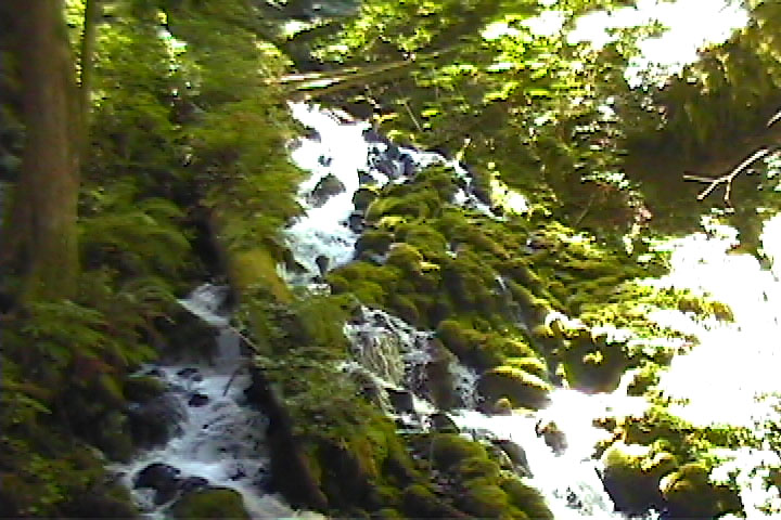
So, per the book's "Columbia Gorge Ice" chapter, the waterfall shown above doubles as a climbing route called "Cruiser" when it freezes. Which I gather is a common climbing term for something that's (relatively) straightforward and nontechnical that can be climbed quickly. Having searched high and low, this appears to be the only name anyone has ever given it. The point of all of this is that I needed a title for this post, so I figured the falls needed a nickname, so here's a new rule of thumb I dreamed up: If it needs a name and all it has is the nickname "Foo" from when it freezes, or dries up, or picked up a name from some other very niche reason, it can go by "Foo Falls". As in, the falls that become "Foo" when they freeze or dry up or whatever. So "Cruiser Falls" it is, I guess. At least it's better than "seasonal falls, columbia gorge", which is what I titled the 2014 post. Which was accurate, but as a general naming scheme it scaled up rather poorly.

Getting to Cruiser Falls is not complicated. The only place to park nearby is a mysteriously large parking lot on the westbound side of the highway, almost directly across from Huerta Falls (a.k.a. "Water Heater" as the ice climbing folks call it -- look for the rusty tank at the base) There are no signs explaining what this parking lot is for, or why you might want to park there. If you look closely a small unofficial sign calls it "Oasis", which is a name but not an explanation. It kind of looks like a trailhead parking lot, but without any trails that start there, official or otherwise. Per a page at Recreating the HCRH, it turns out that's not what it is at all, and it's actually restaurant parking for a long-departed restaurant; the page includes an old photo of the building, which went by a couple of names in its day including "The Dell" and "The White Elephant". At one point decades ago there were a lot of little roadside cafes like this along the old highway, but I gather they generally either went out of business after I-84 opened, or were purchased and torn down as eyesores, in an effort to make the old highway look more remote and natural. Which, I understand the motivation behind doing that, but it's also no fun to realize you need coffee and can't get any without driving west back to the Vista House or Corbett, or east all the way to Cascade Locks, or wait around and hope a parking space opens up at Multnomah Falls someday. So I don't think it would be the end of the world if they at least allowed a coffee stand or a couple of food trucks in a few spots here and there. A thing that will never happen, but I think we could really use here, would be a few German-style "mountain huts" out at the far ends of various long or difficult trails, so when you get to the top of Larch Mountain, or Mount Defiance, or Wahtum Lake at the far end of the Eagle Creek Trail, there's a large stein of an ice-cold pilsner and a platter of sausages and fondue and sauerkraut waiting for you, and maybe a nice spot for yodeling into the hills later if you're so inclined. (I mean, I'm not saying we absolutely have to copy the entire concept down to the menu, I'm just saying it's a time-tested model, and it wouldn't really be authentic without the sauerkraut.) But, er, I digress.

Anyway, I have never seen the Oasis lot anywhere close to full, seeing as there's officially nothing to do there, and nowhere obvious for you to go on foot from there. What you want to do is park there and walk west along the shoulder of the highway for a few hundred feet, maybe a tenth of a mile. If you pass any driveways, you've gone too far. On the south side of the road, look for a sort of east-facing ramp climbing up and away from the highway. It'll be overgrown with brush so you may not notice it immediately -- here's a Street View link that shows what it looked like in July 2019, in case you want to try finding it there first before trying it in real life. (I don't know whether it's even running right now in this hot, dry summer of 2021, though you can go a few Street View steps west and see the creek was running at the same time of year two years ago. If you missed the ramp the first time and are backtracking, there's a similar west-facing ramp for traffic coming the other direction. If you look at the area on the state LIDAR map here, you can see the two ramps join after a short distance and form what looks like an old, long-abandoned road or driveway. This track does a couple of tight switchbacks uphill and then fades out at a flat area that might be the foundation of a long-gone home or barn or other structure. I don't have any further info about what might have been here, and it's all a bit academic anyway since a.) the possible homesite and beginning of the west-facing ramp seem to be juuust over the state park boundary onto someone's private property, although this isn't marked by any signs that I noticed, and b.) there's a big patch of devil's club right in the middle of the west-facing ramp, almost as if it had been planted there intentionally. These two things may not be completely unrelated.

Anyway, after making your way up the east-facing driveway an obvious use path heads uphill toward the falls. So obviously someone besides us knows about this place, and visits often enough that the trail isn't eaten by the forest. The trail turns into a talus slope before long, but finding your way from there is not a big deal, as you ought to be able to hear or see the falls at that point. The route is kind of steep but short, maybe just a few hundred feet to the falls, but steep enough that your calves might remind you of this little mini-hike the next day. Especially if you've been holed up at home for the last year because pandemic. Overall it kind of reminds me of a miniature Mist Falls: You park at the site of a long-vanished early 20th Century business; the waterfall is a short distance from the road, but you may not be able to see it fro there; summer is not prime viewing season; and you get to it with a short but steep slog up a talus slope.

After you've had a look at the falls and taken some photos, unfortunately all you can really do at that point is retrace your steps and head back to the Oasis lot (or wherever you stashed your bike if you arrived that way). There's no trail up to the top of the falls, nor is there a trail over to the next falls, or viewpoint or whatever, to the east or west. You're on State Park land at the base of the falls, but another property boundary seems to run right along the top of the bluff, as if the state bought the minimal amount of land to protect the parts you can see from the road. So probably no trail to the top here anytime soon. In theory they could probably route a trail along the base of the bluff, next to the highway, to at least keep climbers out of the road in case the Gorge ever freezes again. But I gather the state has only owned land here since the late 1970s -- I say 'only' because I remember the late 1970s and therefore it was not very long ago -- and the Gorge as a whole essentially had one big burst of trail construction in the years before and after the old highway opened in 1916, so any place that was in private hands a century ago missed out on the one and only bite at the apple there's been (so far). Which of course comes down to money, or the lack thereof at any time since the late Wilson or early Harding administration. That's the main reason there's no trail here, and why there isn't one at Mist Falls, or a trail up Bridal Veil Creek to the middle and upper falls there, or anything at Moffett Creek, and any number of other places.

In particular, the stretch of Gorge from Angels Rest west to about Portland Womens Forum largely belongs to various state parks, with bits of Forest Service and private land here and there, and it seems like there ought to be a trail or two connecting the various major attractions (Portland Womens Forum / Chanticleer Point, the Vista House, Latourell Falls, Shepperds Dell, Bridal Veil, & Angels Rest, plus Rooster Rock & Dalton Point along the Columbia.) Unfortunately much of this block of parkland was assembled piece by piece starting in the 1950s, and typically there was just enough money to buy the land and not enough to do anything new with it, so no such trail was ever built.

It's not as if there haven't been grand plans over the years. The Gorge Trail #400 -- the east-west connector between a bunch of other trails -- was a late 20th century addition to the trail network. Long stretches of it already existed under other names, but the notion of hiking the Gorge more-or-less end to end did not really occur to anyone until well after the 1910s and 20s. The present-day trail stretches between Angels Rest and Wyeth in two segments, with a long gap west of Elowah Falls where the trail was never rebuilt after an enormous landslide in 1996. A third, very obscure piece of the trail starts at Lewis & Clark State Park at Troutdale and peters out randomly in the woods a few miles east of there (which is a whole other unfinished blog post.) This sort of hints at the original goal of the project, a continuous trail between Troutdale and Hood River, or maybe The Dalles, or points east. It seems like a trail from Chanticleer Point to Angels Rest ought to be the lowest-hanging remaining fruit of the wider project, but even that hasn't been enough to get the thing funded.

There was even a specific (potential) route picked out at one point, in the early 80s before the Trail 400 effort lost steam. If you look at a regular map of the area, say Google Maps, you'll see a couple of minor side roads heading uphill from the HCRH. Alex Barr Rd. is a steep, lightly used single-lane gravel road, but it eventually connects through to the web of rural roads further up and to the south, with homes, farms, horses & cows, even a few clearcuts, and you can easily get to Larch Mountain Road from there. Further east, Henderson Road is just a short access road up to Bridal Veil Lakes, a private event venue more or less above Shepperd's Dell. However if you look at a map that shows official property boundaries, say, a current county survey map, you'll see a few additional roads in the Bridal Veil area that don't appear on ordinary maps, one of which is a mile-long continuation of Henderson Rd. to the west so that it connects to Alex Barr Road, and runs above the full length of the Shepperds Dell bluffs.

That section of Henderson Road (aka County Road 634) doesn't appear on most maps because Multnomah County closed it to motor vehicle traffic back in 1981[1]. But they explicitly did not vacate the right of way entirely, as they wanted to keep their options open for reusing it someday. Namely for reuse as part of a proposed extension of Gorge Trail #400 someday. Which still hasn't happened 40 years later. But at least this stretch of right-of-way remains available as an option, in case the state or the feds ever take a fresh interest in the idea and also find the money to do something about it. Or I suppose if the county found the money, since they still own the dormant road, or maybe Metro since they seem to have some level of actual money to spend on projects like this, unlike the other aforementioned agencies.

The 1981 article further points out that the closed road is a rare surviving fragment of the old Portland-Dalles (or Sandy-Dalles) Wagon Road, the Columbia River Highway's immediate predecessor dating back to the 1870s or so. So there may be some historic preservation value to this bit of road too, if people ever take an interest in saving parts of it like they've done in recent years with the early 20th century HCRH route. I suppose they could even bundle it into the current HCRH project, as that would provide another mile or so of trail where bikes don't have to share the old highway with cars. And in terms of scenic highlights, the Columbia River Images page about Shepperds Dell quotes an old Oregonian article about the falls, which mentions in passing that you could once get to the various upper tiers of Shepperds Dell Falls (most of which you can't see from the famous viewpoint along the old highway) via the old wagon road, so it sounds like there would be at least one point of scenic interest along the way if the trail ever becomes a real thing. Or two, if you count peeking over the top of Cruiser Falls here.

So all of that sounds great, but I have no idea what the present-day road is actually like. I haven't personally checked it out. I also haven't seen any reports of other people checking it out, or any recent photos from the area, so the road could be eroded and unsafe, or overgrown and impossible to follow, or who knows. There's also the inconvenient little detail that the right of way crosses a couple of private landowners' land along the way, and they may not necessarily agree with, or even be aware of, the legal status of the old road, and clearing that up in person is very much Not My Job, thank you very much.


Footnote(s):

The closed road here is actually just one of several now-closed county roads or parts of roads in the general area. Here's a quick list of the roughly Gorge-area ones I know of that are either closed entirely or in part. The links go to pages at the Multnomah County Surveyor's office, as linked from their interactive map, and these rather austere pages in turn link to the original county ordinance creating the road, and the original survey map when one is available. Maybe you weren't aware that county roads even had numbers? I didn't until I stumbled across it a few months ago in a bout of mid-pandemic boredom. I don't think I've ever seen a road sign with a county road number on it. The system is really simple: Road numbers are chronological, and are just the order that a road survey was filed, or that concerned citizens filed a petition asking the county for a new road. The problem with this system is that if (for example) you ever need to reroute a stretch of road around an obstacle instead of over it, or through an obstacle instead of around it, that involves a new road survey and thus a new road number, and if these road numbers were widely used by the public you'd then have to update a bunch of maps and road signs too.

Incidentally, County Road 0001 was an early survey of Portland's Powell Boulevard, filed in June 1855 when the county was not quite six months old; eastside roads surveyed before December 1854 -- and there probably were at least a handful of them -- would have been filed as Clackamas County roads. Along with roads from various other distant places, as the "Clackamas District" of 1843 was a vaguely defined region including everything in the also-vaguely-defined 'Oregon Country' not part of one of the other three, more well-defined districts, which were sort of large versions of today's Washington, Yamhill, and Marion Counties. Everything else south to California, east to the Rockies, or north as far as the "54-40 or Fight" version of the disputed Canadian border was, in theory, Clackamas at one time. Though of course the existing native population was not exactly consulted on this matter.

Anyway, here's that list I mentioned:

  • Road 481 / Rooster Rock Road, the one we explored in the Palisade Falls post
  • Road 377 / Latourell Hill Road, another bit of old wagon road, which drops steeply from Larch Mtn. Road to the town of Latourell east of Latourell Falls and west of the famous figure-eight loops. I gather this was a very scenic but dreaded part of the journey to The Dalles, and one of the chief selling points of the new HCRH was that it rerouted traffic away from this stretch of road, adding switchbacks and the part that loops around the Vista House to create a more 'modern' route, without steep slopes and hairpin bends. Lidar says this road still exists, though nearby landowners have posted unfriendly No Trespassing signs around either end of it. Recreating the HCRH has a page about this road, and I've come across least one OregonHikers trip report about it. The road is still visible as a side road on the famous 1915 birds-eye map of the old highway from when it first opened. Said map even points out the location of "Goat Point", a long-forgotten scenic viewpoint along the now-obsolete old road, and includes a photo of the view from there toward Crown Point.
  • Road 634 / Henderson Road, the very one I was talking about above.
  • Road 566 / Latourell Falls Toll Road, which once connected a sawmill near the falls with the Brower & Thompson sawmill way uphill, near where present-day Brower Road crosses Young Creek. This was originally a private road and its right of way also included a huge log flume, believe it or not. The initial stretch of Alex Barr Rd, and the dead-end bit of NE Toll Rd. off Brower are surviving bits of this old road.
  • Road 458 / Brower Rd. There's a long stretch of the original route of Brower Rd from Young Creek to Bridal Veil Creek & Palmer Mill Road, like the road currently does, but via a longer, more indirect route. From what I can tell this road was created in 1888 and closed to vehicle traffic sometime not long after 1899 and definitely before 1913. But the county has kept it on the books as a county road ever since, for reasons I'm not privy to. I don't know how much actual road remains out there in the forest, seeing as it hasn't been used as a road in over 120 years, and only operated as a road for 10 before that, but there's at least a small initial surviving piece of it near the (present-day) Brower Rd. - Young Creek crossing, about which another draft post is pending.
  • Road 493, which branched off Road 458 and turned south, and continued due south for miles and miles all the way to the county line. This one was vacated back in the 1950s but there may still be remnants of it out in the forest somewhere.
  • Road 550, which branched off 458 at the long-vanished mill town of Brower, then headed due east toward Larch Mountain, then turned south and contoured southeast-ish around the mountain, ending up somewhere deep in the forbidden Bull Run watershed. This is not the same road as the old abandoned Forest Service road NF-20, which contours around the mountain at a different elevation, sorta parallel to Road 550.
  • Road 798, a short road off present-day Brower that was more of a driveway than a full-fledged road. Seems that when the county rerouted Road 458, they took away one landowner's only legal access to public roads, and he threw a fit about it, pestering the county to make things right and create him a new driveway across a neighbor's land. Not a public road anymore but it does exist and will show up in another post that's in the works.
  • Road 625 / upper Palmer Mill Road, south of the bridge/intersection with Brower Rd. This is not the Palmer Mill Road you might be familiar with though, which runs along the side of Bridal Veil Creek, and is a Forest Service road (road # 1520-000) that the USFS has been trying to close and dismantle for years. The county road is uphill of the USFS one and runs roughly parallel to it, before ending up somewhere near the Palmer sawmill (hence the name) along with the long-gone town of Palmer. A surveyed but never-built continuation of the road would have turned sort of northeast from there and journeyed over to Multnomah Basin (but by a different route than the later Multnomah Basin Road), and then somehow switchbacked down to river level somewhere near or maybe east of the unofficial but well-known trail dubbed the Elevator Shaft, so called due to how insanely steep it is. After that taking roughly the same route as the present-day HCRH and ending at yet another sawmill near Elowah Falls. This was largely the Bridal Veil Lumber Company's idea, and would have connected three mills at enormous taxpayer expense. On closer inspection, the road petition turned out to be a sort of astroturfing campaign, as many of the petitioners for the new road turned out to be mill employees. Actual area residents strongly opposed the fantastical proposed road, saying it would be impossible to build, and would be useless if they somehow did find a way to build it, since a wagon road that's too steep for horses pulling a wagon kind of fails at being a wagon road.
  • An unnumbered, isolated stretch of right-of-way near the headwaters of Mist Creek, specifically in township 1N5E, section 13, tax lot 800, if you understand surveying lingo. This puts it close to, but not intersecting, the Angels Rest Trail, close to the point where it switchbacks sharply uphill west of Wahkeena Creek. A township map of the area has an arrow pointing at it with the caption "1956-1798-22"; I'm guessing the first number is a year that this thing was created, but I don't know if represents a survey, a county ordinance, or something else entirely. I have no idea what purpose it was supposed to serve, but it seems to me that a stretch of road that doesn't connect to any other road is of limited usefulness at best.

Sunday, May 16, 2021

Keanes Creek Falls

Ok, next up we're visiting another see-it-while-you-maybe-still-can seasonal Columbia Gorge waterfall. The first one of these was Crusher Creek Falls, which you can catch a brief glimpse of along I-84 while going somewhere more interesting (let's be honest here). This time we're visiting one you can catch a quick glimpse of along the old Columbia River Highway while going somewhere more interesting, honestly, though I do have a fun bit of history to pass along this time. Recall that my goal in this little project was to visit places where I wouldn't run into anyone else or (more importantly) any viruses they might be superspreading at the time. My point of view is that it's better to visit a fourth-rate destination and have it all to yourself than go to a crowded first-rate one and then drop dead and maybe take a bunch of people with you. It still astonishes me that this is a controversial idea, but as we've seen over the last year, millions of people, and entire states, and certain major national political parties violently disagree. As in literally violently. But I digress.

As scenic highways go, the Columbia River Highway gets off to a slow start, and tourists who haven't done their homework are bound to wonder what all the fuss is about until the big reveal at Chanticleer Point. The initial part of the road heading south and east from Troutdale closely follows the Sandy River at a low elevation, with steep 100'-200' bluffs set back a bit from the river. Right along the highway is largely residential, almost suburban, with a handful of scattered businesses, while the land atop the bluffs is a sort of plateau, agricultural and roughly flat, or at least flat enough for tractors, and part of that land is drained by a number of small creeks that tumble off the plateau on their way toward the Sandy, at least during the wet season. Several of these appear right to the highway, as kind of a seasonal preview of what things are like along the highway a few miles east. I've tried counting them a few times under the right weather conditions and usually come up with 5 along the stretch between Glenn Otto and the Stark Street Bridge, plus/minus about 2 depending on how wet it's been recently.

Beyond idly trying to count them while driving, I'd never really paid them much attention, and it doesn't appear anyone else has either. They largely don't have names, there aren't signs for them, or official parking to stop and look, or trails to the top, or anything like that. And let's be honest, nothing along here really holds a candle to what you'll see at Latourell Falls and points east, so the lack of attention is understandable. So a few months ago I was looking through the USGS Geographic Names database for a different blog post, as one does, and noticed that exactly one of the streams through this area has an official, federally-recognized, taxpayer-funded geographic name. And on looking up the GPS coordinates of Keanes Creek on the state LIDAR terrain map, there was obviously a vertical drop of at least a few tens of feet from the point where the creek tumbled off the bluff. I came up with a height of about 45' from the map, but I always seem to overestimate heights that way and I can't say this looks 45 feet high to me -- though the top's obscured by brush, so there may be another 5 feet or so of it we can't see here. The most important detail here is that it's the one waterfall on the creek, and the creek has a name, so -- per the rule of thumb I mentioned in the last post -- it can automatically go by "Keanes Creek Falls". Which matters because I can't exactly do a post about it without a title. Or more to the point, I could do that but without a name nobody will ever stumble across this post as a search result.

The USGS database tells us basically nothing about the name, merely saying dates back to at least 1964, when the name appeared on a state watershed map. A 2016 county survey map included a number of earlier maps for context, and one (unfortunately undated) map (4th image in the doc) shows the surrounding area being owned by a "Thomas Keane", so it may have been "Keane's Creek" at some point and then fell victim to the strict USGS policy against apostrophes -- an FAQ page of theirs indicates that nobody knows when or why this rule came about, but they've only granted five exceptions to it since 1890. I can at least tell you that it's the only creek by this name in the United States, although another Keanes Creek does exist in a mountainous corner of the Australian state of Victoria, and there's a Keane Creek in far northern Alberta.

None of those details make for a very interesting story, so I tried searching the library's Oregonian database for the name "Thomas Keane" to see if any fun leads came up. If we stick to local people and events there isn't a lot of material there: A man by that name broke his arm in a car accident in 1911, and there's a 1921 obit for someone by that name, who may or may not be the same gentleman as the first item, and he -- or they -- may or may not be the same guy from the survey map. Somewhat intriguingly, the obit was followed up by a 1923 classified ad trying to contact the executors of his estate, regarding a letter from a Richard Keane of Queensland, Australia. But that particular loose end stops there, and we can only guess at whether the letter ever found its destination, or what the letter was about. Perhaps the two long-lost twin brothers had a childhood pinky-swear deal to someday name creeks after each other, and it happened as agreed but neither one ever learned whether the other had held up his end of the deal. Or at least that's one of many possibilities.

Of course you don't have to live here to own land here, and a few other Toms and Thomases from around the globe had cameos in the local paper over the years, several of whom would make for a more interesting origin story than "named after a farmer who once owned the land here":

  • A famous Irish actor of the late 19th century; an 1891 article noted that a local theater ensemble had recently hired someone who had once worked with him, which either tells us he was a very big deal, or that our local theater scene was not.
  • A notorious New York gambler, circa 1950
  • A Chicago mob figure who got whacked in 1923, during a gang war over control of the illegal beer trade, because Prohibition.
  • Also in Chicago, a multimillionaire city alderman (and prominent member of the Daley machine) who went to Club Fed for mail fraud in 1974. He appeared in the Oregonian via a lot of cynical Mike Royko columns over the years, like this one from 1973 (while he was under indictment) and a later one in 1982, just to pick out a couple.

The reason I'm throwing all of this at you is that the falls are directly across the street from the the site of a once-notorious roadhouse-slash-dive bar that I do have some links and anecdotes about, and it would really tie this post together if somehow the creek and falls were named after someone a bit more... colorful, let's say. The chain link fence in the first photo surrounds what's left of Shirley's Tippy Canoe, which burned to the ground in January 2020 in a fire authorities described as "suspicious" at the time (though no further news on that front has come out since then). A 2008 profile of the old place's last owner notes that it had long been a notoriously rough biker bar, until she took over and gave it the family-friendly treatment, even bringing in Guy Fieri to have a look at the place for his Food Network show in 2018.

News stories about the fire say the Tippy Canoe dates back to the 1930s, but it seems to have first appeared in the Oregonian in 1946, in an article about the Oregon Liquor Control Commission changing its mind and granting the owner a liquor license for a "Dine and Dance" establishment. Which was a specific category of liquor license back then, and is a term you still see on a few historic bar signs. As I understand it, if you served dinner and offered a dance floor with live music afterward, the state figured you were a high class joint and could be trusted to serve mixed drinks, instead of just beer and wine.

The Tippy Canoe next showed up in the news in 1948, when its liquor license was suspended for 60 days "on the ground that a liquor sale had been made there", meaning shots as opposed to mixed drinks. Which was highly illegal at the time because reasons.

Next up we have a 1951 story in which the bar's owner publicly denied that a sympathetic OLCC agent had tipped him off about an upcoming inspection. It seems that the OLCC agent and several others had been fired for this and other alleged offenses and it all ended up in court, which was embarrassing for everyone involved. The owner related that he had, however, been visited by several OLCC agents employing one of the agency's time-honored stings: The agency liked to hire agents who either were or looked like they might be underage, to see if various establishments checked ID like they were supposed to. However the would-be enforcers succumbed to the siren song of the Tippy Canoe's pinball machines, and after downing three or four beers while playing decided to try to cheat the machine. This got them 86'd, at which point they revealed they were important government agents on an undercover mission. Which must have been hilarious. The presence of pinball machines in a drinking establishment was scandalous in itself in 1951, as they were seen as (and sometimes were) thinly veiled slot machines. And furthermore, it was widely understood that the Portland-area pinball trade was controlled by the local mafia outfit. You might think this would be a long and juicy scandal the papers could milk for weeks or months, but it just sort of fell out of the news after this, almost as if some sort of backroom deal had been made.

This all sounded very familiar, and then I remembered Portland ExposƩ (1957), a low-budget film noir that I wrote about back in 2007. The movie was set in Portland, with at least some exterior shots filmed here. I haven't rewatched it in years, but I remember thinking the outside of the hero's roadside bar was either the Tippy Canoe or the nearby (and similar) Tad's Chicken 'n Dumplings. In the movie, the hero allows a few pinball machines into his bar and quickly gets roped into all sorts of underworld shenanigans, before agreeing to wear the world's most obvious wire for the feds. Using exterior shots of a place widely known to offer such illicit entertainments in real life may have been a little wink at local audiences. Maybe that even counted as product placement, I dunno.

The OLCC semi-liberalized some of its vast galaxy of arcane rules in 1953, finally legalizing shots, the very thing the Tippy Canoe had been busted for in 1948. The Tippy Canoe promptly applied for one of the new "liquor by the drink" licenses and got one. The article goes on to explain that the OLCC also lightened up on advertising rules a bit, legalizing the words "bar" and "barroom", and allowing the use of brand names and sports scenes (but only noncompetitive sports). Other phrases like "saloon", "tap room", and "club privileges" were to remain strictly forbidden. And while it's fun to chuckle at the state's 1950s uptightness, I should point out that you couldn't advertise happy hour drink specials until 2017. If remember right, "saloon" and several common phrases like "happy hour" and "ladies night" were technically forbidden until quite recently, though the ban was not always strictly enforced.

The city's Mafia era tapered off after the 50s, but the Tippy Canoe remained a rough spot long after the mobsters relocated to Vegas. For instance, here's a 1966 item about someone arrested there for assaulting a deputy sheriff. In 1979 the bar's liquor license came up for periodic renewal, and it just so happened that the current Multnomah County chair was a former deputy sheriff, and during the hearing he reminisced about being assaulted by a patron there while on duty, many years ago. The best part is that he was not the deputy from the previous item, and this was just a thing that happened there now and then

In 1982, a couple wanted to buy the place and take over and be the next of a seemingly endless string of owners. The county sheriff opposed licensing them due to multiple rule violations at a bar they'd owned in Oregon City. The county commission disagreed and let them go ahead and have a go at running the place. After that it was mostly just live music listings, and then it closed and sat empty for a number of years in the 90s, before the family-friendly 2000s revival and the 2020 fire.

As for what's next, the site was recently (as in mid-April 2021) purchased by the couple behind the Sugarpine Drive-In at Glenn Otto Park (which I am a huge fan of). It seems they plan to rebuild here, while referencing the original restaurant's midcentury heyday.

So yeah, none of that really relates to the waterfall we're supposedly looking at, so I'm going to have to make a few things up for the sake of a better story. I'd love to be able to tell you this is the only waterfall in the state named for a shadowy mob figure, or spread a rumor about a mysterious safe deposit box key that may still be hidden behind the falls. It would even be fun to explain how 60s bikers often used the falls to get the excess blood and gore out of their gear after a good bar fight; this may have actually happened, as far as I know, but nobody else is going to explain how -- as late the mid-1980s -- you could make a lot of money panning for gold teeth below the falls. Or how I know all of this because our local enchanted nature spirits (naiads, dryads, hesperides, etc.) like to grab a few beers and talk shop after a long day dealing with tourists, and you can kind of eavesdrop if you're in the right place at the right time. And how the one who lives in Keanes Creek always has the best stories, though they all begin with "Long time ago, back in the day..."

Sunday, April 25, 2021

Crusher Creek Falls

Ok, so somehow we're four months into 2021 already, and most of April has been unseasonably warm in Portland, with several days over 80 degrees. It occurred to me that maybe I ought to hurry up finish up a few draft posts I have about seasonal waterfalls before they dry up entirely for the summer, so they might be useful to someone now instead of waiting until the next wet season. Frankly I have no idea whether any of my posts are useful to anyone; over the years I've sort of accepted that the niche this humble blog has settled into is around having the top search engine result on all sorts of peculiar things nobody on earth will ever search for, and few will stumble across by accident. Which would've been a terrible business model if I'd ever had any notions about this thing being a going concern; but it's just a hobby, and one that continues to amuse me after fifteen years, so I'm going to go ahead and keep doing this thing I keep doing.

I didn't want to be a complete shut-in during this global pandemic, so I had a sort of guideline that it was ok to go places where I could be reasonably certain I wouldn't run into a single other human being, or failing that, at least minimize the number of people I was near, or downwind of. Which meant lots of research, lots of avoiding popular places in favor of second-to-fourth rate alternatives that nobody's ever heard of, and in short doing the thing I do here anyway, except now as a responsible civic-minded public health measure, and obviously for self-preservation.

All of which brings us to the subject of this post, an obscure little Columbia River Gorge waterfall you may have glimpsed briefly (if you live around here), but that you've almost certainly never heard of. If you're heading east from Portland on I-84, shortly after the Corbett interchange you'll pass Tunnel Point, where the freeway veers around a rocky outcrop, and the adjacent rail line passes through it in an old tunnel, hence the name. If you look to your right just before the west end of the tunnel, you may catch a brief glimpse of a small waterfall tumbling down the bluff just beyond the tracks Unless the creek has dried up for the season, or the falls are obscured by vegetation, or you blinked while whooshing by at some multiple of the legal speed limit. If that brief glimpse caught your fancy for whatever reason, and you wanted to get a better look at that waterfall, you can do that from the Tunnel Point scenic viewpoint, but it's only accessible to westbound traffic, so your best bet is to turn around at one of the upcoming exits -- Rooster Rock, Bridal Veil, Multnomah Falls etc. will all do the trick here -- head back west, and pull off at the un-numbered exit labeled simply "Scenic Viewpoint". And yes, the viewpoint is pretty scenic (albeit really noisy due to the freeway), but you can't quite see the little waterfall from the viewpoint itself. To do that you need to walk west another 200-300 feet; there's enough ground between the freeway guardrail and the Columbia River that you can do this safely, maybe even enough space to set up a tripod for proper waterfall photos (which I obviously didn't do), though you may wonder whether it's really worth doing thanks to all the noise and freeway garbage and so forth. Once you get to the falls you can take your photos and hopefully get a few without cars or trains in them, and impress your friends, and internet randos too, as if the two things are all that different in 2021.

Your friends may politely ask some followup questions, like how tall it is or what it's called, either out of genuine curiosity or because they like you enough to continue humoring your weird hobbies. I don't have an official height number for you, but I tried measuring it with the state LIDAR map and came up with something around 45' in two tiers. I've found I tend to come up with somewhat larger numbers this way than the official numbers, when there are official numbers, so let's say it's somewhere in the 35'-45' range. As for the name, it honestly isn't impressive enough to have an official one, or to have picked up an unofficial one, but at least we can apply a common rule of thumb here: If a creek/stream/river/bayou/etc. is named X, and there's only one waterfall on it, and the falls don't already have a name, they are automatically X Falls, more as a unique description than a name. The rule applies here because -- weirdly enough -- this little creek goes by Crusher Creek, which has been its 100% official, US Government-approved name since 1986, although the entry insists this spot is somehow part of Clackamas County. Despite the 1986 date, the name is not a reference to everyone's least favorite TNG character; the USGS page references an earlier State of Oregon water resource map from 1964, before even TOS had hit the airwaves. Instead, there's a clue elsewhere in the USGS database, in a 'locale' entry for "Crusher (historical)", which points at a spot just on the other side of Tunnel Point from the creek and falls.

Strictly speaking those coordinates are out in the river, which seems unlikely. But transcription errors do creep into the database now and then, and if you just tweak the 2nd digit after the decimal point in the entry's latitude, that puts you on dry land near the Union Pacific railroad tracks. Which is important because the USGS database entry references a 1916 Union Pacific timetable as a primary source, by way of the 1996 book "The Railroad Stations of Oregon" by Lewis L. McArthur (who you might remember from the Wiesendanger Falls post a few months ago) and Cynthia B. Gardiner. The book isn't available online, and it's out of stock at both Powells and Amazon, so I don't have a definitive answer on what sort of locale we're talking about here. But going by the name my guess is that it was the site of a literal rock crusher, producing gravel for the railroad, and not a long-lost town by that name. There's a Rock Crusher Creek located in a remote corner of Coos County as another example of what I think happened here. From the look of it, rock crushing machinery produces a lot of dust, and it's good to locate your operation near a convenient source of water for dust control. So the creek was named for a long-gone railroad facility it might have provided water for, and the falls are quote-unquote named for the creek, and it's not really history's most thrilling origin story, is it?

Updated: Ok, I tracked down a 1915 county survey map that confirms it was a rock crushing operation, not a town. The map shows it had a rail siding and a dock, a main building that I imagine was for the crusher operation, plus a few outbuildings that might have been employee bunkhouses or something along those lines, so maybe it depends on how you define "town". It was just west of another creek now known as Rainbow Creek. So it's possible the name "Crusher Creek" used to apply there and sort of migrated over time, as names tend to do, especially when the name isn't very important anymore and nobody's paying close attention.

So for the sake of argument, let's suppose the last paragraph was completely wrong, and the mid-river location from the USGS is accurate. Suppose that was once the site of a notorious enchanted wandering rock, cousin to the Planctae and Symplegades of Greek mythology, united by their hatred of ships and boats of all kinds. As with all wandering rocks down through the ages, opinions vary as to whether the rocks wander of their own volition, or only do so after the captain's had an extra flagon or two of seafarers' grog, as with the Exxon Valdez. 19th Century settlers couldn't pronounce the millennia-old name local tribes had given it, and instead simply called it "Crusher", the bane of paddlewheel steamboats and riverboat gamblers and that whole milieu for the few decades when that was a thing here. Turns out there was a railroad station nearby, also named Crusher, at a spot where Portlanders of the era would come to picnic and watch boats try to run the gauntlet, and gamble on the outcome. After a few decades of this, the Corps of Engineers finally showed up and broke the curse with more dynamite than was strictly necessary. They'd intended to completely demolish the rock but ended up merely driving it ashore, where it remains to this day as present-day Onion Rock, located along the riverbank maybe 1/4 mile upstream of Tunnel Point, and it either learned its lesson or it's merely licking its wounds and biding its time and could resume its predations any day now, geologically speaking. To mark the day of the great dynamiting, a local poet who claimed to have gone to college Back East was commissioned to write the usual Victorian epic poem on relevant mythological themes (and how those myths would have turned out if the heroes had had modern explosives). We won't get into whether the epic poem was any good, since the last time I criticized somebody's poem I got an angry email from a descendant of the poet, outraged at my mild insult to his long-deceased ancestor. After the events of the big day, reporters filed breathless wire stories for the big eastern papers.... and the entire East Coast laughed at us, and how we bragged on and on about successfully bullying a magic rock, and it was all very embarrassing, and it instantly became one of those episodes we all agreed to never speak of again. Somehow no photos of the dynamiting have survived, nor have any of the rock preying on innocent steamboats, and no copies of the epic poem have survived either, and the boring cover story about a rock crusher has fooled almost everyone for the last 150 years or so. But only almost everyone. So you can take my word for it, or not, that's entirely up to you.

If all of this has left you wanting a better look at the falls than what I've got here, there's unfortunately no easy and straightforward way to do that. If you lift the "easy and straightforward" limitation, it looks like there's might be a way, though I haven't actually tried it and can't recommend it. Look closely at a terrain map of the area (like the LIDAR map linked earlier), or at old photos of Tunnel Point like the one on this state history page, and you can see a steep old road down the west side of the point, south of the tunnel, starting up on the bluff at (I think) a wide spot along NE Reed Rd. and ending up somewhere near the base of Crusher Creek Falls. I don't know whether this was an old road down to the river from before I-84 went in, or it's simply a railroad service road, maybe for tunnel maintenance. Either way, the whole thing seems to be on railroad-owned land now, so if you really want to do this your options seem to be, in order of difficulty: a.) trespassing successfully, b.) contacting the railroad somehow and asking nicely for permission, and (I assume) at minimum promising not to get on the tracks or walk through the tunnel or touch any of their equipment, c.) convincing the railroad to hire you into some sort of job that takes you here officially, or d.) making like most civilized countries and nationalizing the railroads, which (among other things) would make this spot public property. This, in turn will most likely involve either winning a few elections or somehow awakening class consciousness in the US proletariat. But hey, I didn't say this was going to be easy.

Wednesday, March 31, 2021

Kailua Beach and the Last Normal Day

Last week I got my second COVID-19 shot, vaccinating me against a disease that virtually no one understood a year ago, one that didn't even exist in humans a year and a half ago. I'm sure I don't have to describe what the last year-and-change has been like. And now with a tiny light at the end of the tunnel, this month we all had to relive how it began, a month of strange, difficult, and sometimes tragic one-year anniversaries. For my part, the day I keep thinking back to is March 9th 2020, which stuck in my mind as the last normal day of the Before Times, before all of this happened.

In truth it really wasn't a normal day at all. I was on vacation, a long-planned trip to O'ahu after a stressful work project had finally wrapped up. I needed time away from that and from a bunch of serious family medical things and related drama, so despite the reports of a strange disease popping up in a remote corner of China I rolled the dice and got on a plane, and then spent most of the trip holed up my condo anxiously reading coronavirus news as things rapidly went from bad to worse across the globe. One morning I decided to try to have at least one normal vacation day before heading home, figuring then I'd lie low for a few weeks after that until the virus situation was over. So I hopped on a city bus and made my way over to Kailua, a suburban beach town on the windward side of the island. The plan for the day was not ambitious: just go walk down the town's famous beach to see what it was like, take a few photos for the humble blog, and then maybe check out a new brewpub/taproom that had recently opened along the town's main drag. My notes from a year ago say I had a mask with me on the trip, but I have no recollection of whether I wore it on the bus or in the pub or on the flight home.

It was dim and grey out and it drizzled on and off all day, and I passed several people on the beach wearing sweatshirts and huddling up for warmth, just like Oregonians do at the coast; imagine that but 20 degrees warmer. It's tempting to laugh at people acting that way in 72 degree weather, but you don't have to be there long before any hint of temperatures below the low 80s registers as cold. Especially when all the other weather cues that register as "Pacific winter storm" are present, and other people are acting like it's cold outside, and the local restaurants are running winter specials heavy on the hearty soups and stews and whatnot.

I figured I'd start at the Kailuana end of the beach and walk south til I got to Kailua Beach Park, not because different parts of the beach are significantly different from each other, but that if I just went there to sit on the beach and shiver in 72 degree weather, I would inevitably end up staring at my phone and looking at virus news instead of having a proper vacation day. So step one was just to find the beach access. I had read conflicting things about where it was, and ended up wandering through a subdivision where all the street names are "Kailuana"-something, looking for the Kailuana beach access. I even saw what looked like a beach access, but it was gated off, and eventually I ended up back out on Kalaheo Avenue -- the main drag through the area -- and eventually sighted the actual beach trail just a couple of doors down from the subdivision. It turned out to be a long, neglected-looking alleyway between swanky houses, marked by a heavily vandalized city park sign.

It turns out that my initial guess was not totally off the mark, though. The black gate I saw, with the red letters spelling out "Private Property No Trespassing" really is a beach access spot, but it's a members-only gate for the local HOA. Now, the subdivision itself isn't gated, and its streets are public, and people can and regularly do park on the street and take the slighly roundabout path to the beach from there, often with surfboards in tow. And the beach on the far side of the gate is a public beach, by state law, and royal proclamation before that, and by local tradition going back endless centuries. But thanks to a little platting-and-deeding magic the subdivision got an exclusive beach path for themselves, in exchange for also putting in a beach alley nearby for the peasants. Which is one of the more tremendously petty things I've seen in a long time. It also tells you who has the power within the HOA: If your house isn't right on the beach, and you're the sort of person who frets about outsiders disturbing your genteel peace and quiet and so forth, you may actually have more people walking past your house to get to the beach the roundabout way than you would if the gate was just open to everybody. For some residents this also means outsiders walking down an alley that backs up to your backyard.

Of course the nature of rich people is that beyond every velvet rope is another velvet rope: The 0.1 percenters will need to wall themselves off from the mere one-percenters, and the 0.01 percenters can't bear to live among the smelly 0.1 percenters, and so on. So it won't surprise you that at the far end of the neighborhood I wandered through is a second gate, and residents' beach keys don't fit this gate. Beyond it, Kailuana Place continues out onto a narrow spit of land between the ocean and the Kawainui Canal, inhabited by the next-most-exclusive tier of rich person. One of the houses out there repeatedly served as the "winter White House" during the Obama administration, and the president could only afford it as a vacation rental.

So I ran into a cul-de-sac at this point, not a literal subdivision-type one, but a dead end while puttng this post together; I had a few more links radiating out from this land use situation that I couldn't quite mash into a good storyline, and that in turn was blocking me from finishing this post, and I ended up stuck at this point for several weeks, and here I am after dark on March 31st trying to finish a one-year-ago-this-month post about the previous March before it stops being the following March. So here are a few of the links I had that I didn't quite want to just toss out: A couple about the security zone that was set up here during the Obama era, and I was going to toss in a gratuitous link to a post here from a few months back snarking at Mar-a-Lago. Was also going to veer off on a tangent about a similar controversy over on Kaua'i where a commenter referenced the situation here, and another tangent about beach access in Oregon that I'd already kicked off to a footnote. And a couple of links explaining that bike access is a problem here too.

So moving right along, I made it to the beach and walked along for a while and took the photos here, ending up at crowded Kailua Beach Park; evidently it was a great day for kiteboarding, and colorful kites filled the grey sky. Although I somehow neglected to take any photos whatsoever of any of this, and I have no idea why not. From snippets of conversation I overheard, several of the people there were quite well-known within the sport, though I didn't catch any names and would not have recognized them if I had. Also I'm terrible at names and faces and would not have linked the name to the right person, and long story short, I am the world's worst papparazzo and if you came here looking for stale year-old kiteboard celebrity news, I'm afraid this is not your lucky day. If you continue down the beach at this point you'll end up at Lanikai Beach and near the popular end of the Lanikai Pillbox Trail, which I didn't do since I've already been there and done that, on a much sunnier and dryer day.

Besides, I was already focusing on goal number two for the day, tracking down the new-ish Olomana Brewing taproom, in an older building along the main drag through town. Had a couple of beers and chatted a bit with the owner and some of the other patrons there; as of press time this is still the last time I've had a beer in the presence of other human beings. Turns out there were a couple of other people from Portland there, which happens a lot; I suppose Portlanders visiting breweries while traveling is sort of a busman's holiday thing, pursuing Portland-y interests as best we can elsewhere, while the puzzled locals look at you like you're some kind of obsessive weirdo. In my defense, I'm almost positive I've never quizzed anyone about IBUs or mashing times or canning vs. bottling while on vacation, since it's a life goal of mine to never be That Guy. But I have had people volunteer these details and more, completely unasked, after hearing the word "Portland".

At least hiking is a popular local thing on O'ahu and nobody looks at you funny about that. As a matter of fact, the brewery is named after a local cartoonishly-steep peak that looms over the Kailua area. Olomana is widely thought to be one of the scariest and most dangerous hiking trails on O'ahu, home to a long list of fatal accidents over the years. I have never attempted it, and it's not really high on my todo list, as roughly the entire route is along a razor-sharp narrow ridge with tons of exposure, which I admit I am no big fan of. Narrow, as in nearly two-dimensional narrow, and you're hiking along the edge of where a third dimension ought to be and isn't. And calling it hiking is a stretch as I gather you spend much of the route relying on ropes of unknown age and provenance for help getting up and down slopes of up to and beyond vertical. And there's mud everywhere, and the mud doesn't provide any more traction than it does anywhere else on the island, and it's wet and muddy a lot more here than most parts of the island, thanks to being an isolated peak just windward of the windward side of the Ko'olaus. At this point I'd sort of like to point you at UH Manoa's interactive rainfall map to demonstrate just how much wetter it is than the surrounding parts of the windward side... but it's a small microclimate and the university doesn't have a weather sensor on top of any of the peaks, as this would involve climing the peaks a lot in all weather conditions. So Olomana is essentially invisible on that map. But since the point of this sensor network is to extrapolate conditions across the whole island from a limited sensor network, your model may be more accurate overall without a few mountaintop sensors sending in wacky outlier numbers all the time. You'd never guess that the highest point tops out at just 1644'.

In lieu of veering further down another cul-de-sac at this point, there's more info about climbing the thing (if you're so inclined) at SummitPost, BodeDotCom, OahuHike, Oahu Hikes and Trails, The Hiking HI, and The Outbound and a couple of typical videos.

As I was leaving the pub I mentioned I was heading back to the mainland in a few days but would be back after the virus thing was sorted out. Which I'm choosing to think of as a somewhat delayed but still-pending todo item, since both they and I seem to have survived this recent unpleasantness. Maybe in a few more months, depending on how things go from here.

If you've paged through the photoset you might have noticed a couple of photos of a rooster. While I was waiting for the bus home, he strolled by on the sidewalk, ignoring everyone standing there, and all the traffic on the adjacent four-lane road, and everything else except for a fellow rooster on the far side of the road. The two kept yelling at each other over what I imagine was some sort of property dispute; you'd think the busy road would appear as a reasonable and fair natural boundary, but no, the rooster from our side had to dart across the street, oblivious to traffic, to press the battle in the distant land of Other Rooster. I'm fairly sure there's a vintage George W. Bush or Dick Cheney quote explaining why preemptive invasions are an essential part of self-defense, but I can't be bothered to look it up at the moment. Anyway, he made it across and they chased each other out of sight, and may still be fighting it out, given how that sort of conflict tends to go, especially if either of the roosters has somehow discovered oil.

Once I got home it was back to virus news stories, and a couple of days later was the day Tom Hanks caught the virus and the NBA season was canceled and the rest was history, and a few days after that I made it back to Portland while trying not to breathe too much on a 5 hour flight, just in time for a family memorial service that ended up being canceled, and then stores began running out of everything, and certain presidents insisted it was all just a big hoax, and, well, you know the rest.

In honor of spending the last year indoors messing around on the internet instead of going places, I put together a little YouTube playlist of island music, which is the sort of goofy sentimental thing you do when a place you're fond of suddenly becomes infinitely far away for the foreseeable future. I can't quite figure out whether the shots walking down an alley in the first video are from the beach access thing I mentioned earlier, but it looked a lot like that, anyway. I'll probably think this is vaguely embarrassing when I look at it a few Marches from now, but here goes:


footnote(s)

Oregon beach access thing

So the weird Oregon beach access thing that I wanted to tell you about at one point is about Little Whale Cove, a small inlet on the coast near Depoe Bay, home to an upscale gated community and best known for a notorious 1980s court case. Oregonians of a certain age will go on and on about the famous Beach Bill, a 1970s law that guaranteed public access to the state's beaches and limited development of tideland areas. They won't tell you it was based on an earlier law in (gasp!) Texas, or that the legal trick that made coastal protections possible here was declaring the state's beaches an official state highway. Which is why the state highway department ended up in charge of dynamiting a beached whale in 1970. Anyway, sometime in the 80s developers noticed this one cove near Depoe Bay had a little geological quirk where at low tide the cove became a pond detached from the ocean by some rocks or a sandbar or I'm not sure what exactly. Some fancy lawyers figured out that if you read the beach bill just the right way, the cove was maybe not part of the ocean and the beach wasn't covered by the law and you could fence it off and keep the peasants out and have a proper California-style gated community, and best of all it was the only one of its kind that was possible anywhere on the Oregon coast. So they went ahead with the project, and fought the inevitable court case all the way to the state Supreme Court, and won. But given the unique geology it turned out not to be the statewide apocalypse that some predicted at the time, so they've just sort of been there since then quietly keeping to themselves and doing whatever it is that rich people do at the coast.

Except that it turns out one of those rich person things involves keeping the public away from nearby, non-little Whale Cove as well. You might think that would be tough, since there's no geological loophole there, and the beach is actually part of an official state park. Ah, but if you can manage to buy up the land people would have to cross to get to said beach, and donate it to the nearby National Wildlife Refuge that's absolutely closed to all public access forever, that protects your precious privacy in a way nobody can criticize without seeming like some kind of earth-hating SUV monster. So that's where things stand right now. And at whatever point the largely-theoretical Oregon Coast Trail becomes more of a thing that exists along the central coast, this whole area is going to be a big barrier they'll have to work around somehow.

The inability to go to either cove and take photos is why this situation is relegated to a footnote in a Hawaii post instead of getting a proper post of its own. FWIW.


another playlist

Since I'm in a rare playlist-sharing mood at the moment, I figured I'd drop in a bonus one. This time it's some music from the (ex-Soviet) Republic of Georgia, a place I've been intrigued by since college but have never visited. According to the interwebs, life there seems to revolve around wine and feasts and singing and dancing (with swords) and related extrovert things that I would not actually do in real life, but which seem endlessly compelling on cold winter days when you literally have not encountered a single live human being in person in weeks, and you'd recoil from them anxiously if you did. Anyway, here:

Sunday, February 28, 2021

Upper Multnomah Falls


View Larger Map

Ok, it's time for the next stop on our ongoing (and very slow) virtual hike around the Multnomah-Wahkeena Loop. The Larch Mountain Trail (which we've been on so far, other than the detour over to Little Multnomah Falls) has a junction with the Wahkeena Trail at the 1.8 mile mark, and right around that point Multnomah Creek goes over a cluster of 5'-10' drops, maybe 35' overall. It's a pleasant enough spot, though not one of the scenic highlights of the trip, and I was surprised to learn it's been saddled with the name "Upper Multnomah Falls", a name that leads to all sorts of unmet expectations. After figuring this out, I went back and found that I'd taken photos of it on at least three separate occasions, never thinking "hey, cool waterfall", just that it was an especially photogenic spot along the creek. Still, it had a name (albeit a dumb one), and I had photos of it, and that meets what I admit is a low bar to be included here, so here we are.

The name made it harder to research this post than it needed to be, since the majority of places we've visited in this project have been called "Upper Multnomah Falls" at some point or other, and the one we're visiting now is way more obscure than any of these others. Once you wade through all of the irrelevant search results, there isn't a lot of material left out there on the interwebs. Because I'm hanging out at home with the cat during a pandemic, I went ahead and waded through said results. You'd think this would've been a quick and easy post to write once I was done collecting every last thing I could possibly find on the internet about this little spot. But no, it ended up as a lengthy depth-first exploration of every last side diversion I've bumped into along the way -- again because pandemic -- none of which I can quite bring myself to delete. I am at least slowly learning to kick stuff down to the footnotes when it doesn't relate to the main point of a post, though, the first footnote being an extended bit about the name, and where it came from, and when, and why you probably haven't heard of it. The TL;DR is that the waterfall (and the use of the name here) may have originated with a 1983 guidebook, and then it largely fell out of favor by the mid-2000s. As far as I know the waterfall itself did not change at all during this time, and this is all just people having opinions and a consensus slowly shifting over a few decades.

In any case, the Upper Multnomah we're visiting right now does have one minor claim to fame. There's an undated infographic I've run across a few times that explains that there are precisely eight kinds of waterfall out there in the world [footnote: 'geology'], and you can collect the whole set just by visiting a few spots in the Gorge. In particular, you can see five of the eight just by doing the Multnomah-Wahkeena Loop, with Upper Multnomah here representing the "cascade" variety. (Hiking to Triple Falls from the Horsetail trailhead will get you two of the remaining three, and you can finish off the set at the first falls on Eagle Creek, fwiw.) The standard caption for cascade-type waterfalls explains this variety "[t]umbles along a series of rock steps. You'll find a fine model by following the directions to Dutchman Falls, then hiking 0.2 of a mile (a total of 1.9 miles from the trailhead) to Upper Multnomah Falls, near the junction with Wahkeena Trail #420.". Here are a few contemporary examples of where this infographic has showed up:

So my personal theory, which I can't prove, is that the name was bestowed here and persists because of this grand tour of waterfall types. There are probably dozens of similar spots around just the Oregon side of the Gorge where some creek drops at least X number of feet over a distance of no more than Y feet, for whatever threshold values of X and Y you've picked out, and almost none of them have names, but this one gets singled out because it's on a route visitors would be on anyway on their way from the "Block" example at Dutchman Falls, and the "Fan" example at Fairy Falls over on Wahkeena Creek, or vice versa.

Some assorted sightings of the falls from around the interwebs:

  • Oregon Hikers Field Guide has a nice pre-fire photo titled "UpperMultnomahFalls.jpg", used but not named in the Larch Mountain Trail article .
  • It also gets mentioned in passing in a few of their forum threads:
    • A post in this thread calls it the "Rodney Dangerfield of Multnomah Creek Waterfalls"
    • This one includes an artsy photo labeled Upper Multnomah but which might be Little Multnomah; it's hard to be sure because artsy.
    • Another thread says it was actually impressive when they visited, unusually, but they didn't take a photo
    • Someone else was unusually impressed by it in a 2013 thread, and included a nice photo.
    • Yet another thread miscaptions Little Multnomah as Upper, but also has a photo of the "real" Upper Multnomah. I think. It can be hard to tell from some angles.
  • On Flickr, an artsy pinhole photo that might(?) be of the right place
  • A few more photos by various Flickr users, found either by name or by geotag, at least some of which seem to be of the same spot I keep taking photos of: [1] [2] [3] [4] [5] [6] [7] [8] [9]
  • Someone's blog post with a bunch of Boy Scout hiking photos, including a view of Upper Multnomah taken while doing the Multnomah-Wahkeena Loop.
  • Someone else's 'I should take a photo of that' photo, part of a longer hike, including stopping by Nesika Lodge, and the weird trail with the christmas ornaments and/or toothbrushes somewhere up in Multnomah Basin. Fwiw if you happen to be in that area, there's also a long-abandoned 1931 Buick up there somewhere, though I've personally never bothered to go looking for it. Just not my thing, I guess.
  • An undated OregonWaterfalls.net photo captioned "Upper Multnomah" doesn't quite look like the place pictured in the blog post, but it might still be the same from a different angle.
  • A Youtube video of hiking down the Larch Mountain Trail from the third footbridge to Ecola Falls, with a chunk in the middle lingering over Upper Multnomah. Kind of the same thing I didstarting at 1:23
  • It showed up in someone's 2003 blog post (with a tiny photo) about the Multnomah-Wahkeena loop.
  • Was also mentioned on a somewhat idiosyncratic list of waterfalls at The Columbia Experience. I'm not 100% sure he's talking about the same place, but the list is mostly ordered geographically, east to west, then north to south, and it's in the right location in the list anyway. Though Dutchman and Little Multnomah are swapped, and the whole Wahkeena list is swapped with the Multnomah list, so who knows.
  • A stock photo on Alamy

Oh, and I did find one possible historical photo, in a 1924 issue of The Camera. The magazine featured a monthly Print Criticism section, in which you -- the hopeful reader -- could submit a photo, and the magazine's team of experts would make fun of it (and you) to a national audience. But at least a small copy of your photo would be seen by a national audience, which is fantastic if you believe the old adage about there being no such thing as bad publicity. Here's what the critics had to say:

“Leaping Waters”, by B.G. Smith.

We have no doubt but that this subject looked most beautiful to the artist. He looked at it with a poetic eye, as his title betrays, but the glamour of the theme veiled his eyes to its lack of pictorial interest. He fails to do even justice to the facts, because he surrounds them with so much uninteresting matter that these surroundings become of more importance as space fillers than the falls itself. There is everything here one could want to make a picture with, the falls, the dominant feature, but by the failure to identify interest where it is demanded, we have, instead of a picture, a mere mass of conglomerated areas of almost equal intensity, and a mere bit of white supposed to represent the beautiful falls, no separation of the planes whatever. Everything in the one vertical plane, no depth or distance. Had the photographer, first of all, studied the proper angle of light, we would have had the water of the falls look like agitated water instead of wool, and the quiet pool transparent, instead of an ink well. We do not know whether the photographer was pleased with his results or not. We credit him, however, with enough taste not to be — and that he sent the subject to get our opinion of it. Our suggestion is to try it again, but spend the whole day if necessary to get it pictorially.

Made on the Larch Mountain Trail with a Korona view camera equipped with a Goerz f/6.8 lens. The exposure was 1/10 second in the shade at 2:30 P.M. in September; Eastman cut film developed with pyro; print on Artura.

Ouch! Sadly the scanned copy of the magazine is too dark and lo-res to form a fair opinion of the photo, quality-wise. On one point of the critique, a 1/10 second exposure of any waterfall made by anyone, will tend toward the "wool" look as they call it, not agitated waters. And given the slow film speeds of 1924, and the lens's max aperture of f/6.8, and how rarely you get direct sunlight in the Gorge's north-facing canyons, giving them their agitated waters might not have been as easy as just hanging around the right spot waiting for inspiration to strike. Besides, the "wool" look is now the standard aesthetic for quality photos of Gorge waterfalls and it's been that way at least as far back as the 1960s Ray Atkeson photo books. So a big "pshaw" to the whole agitated waters thing. I do think Smith could have improved his photo by cropping it a bit, though. Although it's not as if I usually bother with that for my Flickr photosets, so take that with an appropriately-sized grain of salt, I guess.

And just as a little curveball, another OregonHikers thread I ran across includes a map that places an "Upper Multnomah Falls" another mile upstream around the point where the Larch Mountain Trail splits into Low and High Water routes, and a "Double Falls" maybe 1/4 mile downstream, and nothing at the Wahkeena trail junction. I don't recall seeing anything that looked like a waterfall upstream of the one here, and I think I would have noticed one, but I've been wrong before. Multiple times, even. I suppose I'll have to go look again after the pandemic's over.


footnotes

Naming

If you do any sort of search for the phrase "Upper Multnomah Falls", nearly all of the results will be for the upper tier of Multnomah Falls (here for example, and here.), which -- to me -- is the most logical place to apply the name. But it's also an old name for the Wiesendanger Falls & Ecola Falls combo, so there are a few results for both of them as well, like this page , and this circa-1992 jigsaw puzzle, sold nationwide, and most of the then-canonical guidebooks by Don & Roberta Lowe. Their original 100 Oregon Hiking Trails (1969) didn't use the name, but the ones that followed did, starting with 70 Hiking Trails - Northern Oregon Cascades (1974) and running thru at least the late 1980s. A few other search results point at Little Multnomah Falls (like these photos), I guess on the entirely reasonable theory that it's right above regular Multnomah Falls so it must be the upper one.

The earliest use I've found of "Upper Multnomah Falls" for this modest spot is in Gregory Plumb's 1983 guidebook Waterfalls of the Pacific Northwest, which evolved into the long-running A Waterfall Lover's Guide to the Pacific Northwest, published in five editions (so far) beginning in 1989. The 1989 Waterfall Lover's Guide is the earliest version Google Books has, and it (like the 1983 book) describes the falls briefly, rating it at one star out of a possible five: "This 15-to-20-foot drop can be viewed from Larch Mountain Trail #441 about 0.2 mile past Double Falls (see directions above), a total of 1.8 miles from the trailhead near the junction with Wahkeena Trail #420.". The book's present-day companion website also has a page for the falls, still rating it as a single star.

I haven't found any examples of it being called anything else before 1983, or of it being singled out as anything special apart from all the other rapids and cascades above Ecola Falls. The book doesn't claim to have originated using the name here, but any prior uses of it don't seem to be online anywhere. The one-star rating is a common theme, as you'll see in a bit here; I think it gets docked points due to a) not measuring up to the grand-sounding name, and b) being compared to everything visitors have just walked by on the way there. In many US states it would qualify as a major local tourist attraction on its own merits. (I was originally going to make a wisecrack here about waterfalls in Kansas, but then I googled it, and then a few other even flatter states, and (because pandemic) that particular tangent became another footnote.)

The undated infographic I mentioned up above might be older than 1983, but I can't prove it. Oregon Off The Beaten Path was first published in 1991, though I don't know whether it used the graphic before 2005, and the hand-drawn illustrations of 'generic' examples of each waterfall type are in a style that to me looks very 1970s or early 1980s.

The 1998 guidebook Romance of Waterfalls mentioned the falls briefly in its Hidden Falls (aka Ecola Falls) entry, saying that from there it was ".2 miles, 10 minutes to Upper Multnomah Falls, a rather insignificant falls which is often barely noticeable under logjams". Later on the entry explains "We have chosen not to include Upper Multnomah Falls, a few minutes upstream from Hidden Falls, in the book. It's an artistic judgement. Take a look anyway, and decide if we did the right thing."

The Northwest Waterfall Survey once had a listing for it, per a December 2001 Wayback Machine snapshot, said "Though there isn't any "real" waterfall past Hidden Falls, as long as you're here, you may as well walk the .2 mile from Hidden Falls to this rather sad little drop along Multnomah Creek.". Because this was posted close to twenty years ago, the page's hint to photographers said "Don't waste film here like I did (unless you need to finish a roll)." A 2006 version of the page mellowed out a bit toward the little waterfall, albeit while explaining it shouldn't be in the datatabase at all:

While the last major waterfall along Multnomah Creek is technically Ecola Falls, the stream beyond is exceptionally scenic, pockmarked with small drops here and there. This 10 foot ledge is the largest of those. This drop is included in here more as a disambiguation than anything else. Future overhauls to this database will see this entry removed. ... Photography Tips: This one is scenic, worth taking pictures of, but not necessarily as an illustrative waterfall scene.

And sure enough, no trace of it remains in the present-day database. I think they came up with the 10' height by just counting the single tallest drop and not the ones immediately above or below it.


Waterfalls in very flat states

As I mentioned above, Upper Multnomah would qualify as a major waterfall in Kansas on its own merits, and possiby as an important visitor attraction, or at least a local swimming hole. Note that I am not making fun of Kansas here, just noting things are always graded on a curve, and Kansas has a different set of local standards. For one thing, some of the ones listed in the two links above are artificial ones including dam spillways and others where water just sort of finds a different, natural-looking path out of a reservoir, and a 3' drop is worth writing about if it looks impressive enough otherwise. The deal is that while the state certainly looks flat, it's kind of tilted like a table with a bum leg. So the highest point in the state is tongue-firmly-in-cheek Mt. Sunshine, on the Colorado border, at 4309 feet above sea level, while the lowest point is somewhere on the Oklahoma border at 679 feet elevation. 3630 feet is equivalent to Multnomah Falls stacked on top of Yosemite's El Capitan, but it's barely noticeable when spread out evenly over the width of the state.

A news item out of Chicago points out that Kansas is only the seventh-flattest state, with Florida in the lead and Illinois taking second; it reads kind of like they're proud of the fact. That article is based on a 2014 paper "The Flatness of US States" by two University of Kansas geographers, one of whom describes the work here. So I wondered what the six ahead of Kansas had in terms of waterfalls, and got to googling, because pandemic.

  1. Florida. Most search results on Google Maps named something-something falls are retirement communities, garden stores, or tourist traps, but I did find a few results, largely concentrated in the panhandle or the stretch along the Georgia border:
    • Boonie Falls just 3', between Orlando & Cape Canaveral. Naming a 3' waterfall seems absurd if you've never been to this part of Florida, but it really is that flat. I might actually go track this one down the next time I'm in Florida, since it's the only part of Florida I visit on anything close to a regular basis, due to rocket launches.
    • Falling Creek Falls, 10'
    • Steinhatchee Falls 4-5'
    • Falling Waters Falls, a whopping 73' but flow depends on having rained recently, and water is falling into a deep sinkhole
  2. Illinois has several completely normal ones; I guess the deal is that they're concentrated in the far southern tip of the state, the rest of which is pancake-flat.
  3. North Dakota has exactly one waterfall, according to the internet, and it's... not spectacular. This actually surprises me, given the (relatively) rugged and remote western end of the state, home to a two-part national park. But if there are any others, either nobody's talking about them or nobody's discovered them yet. I would have expected a colorful tall tale about it, like Teddy Roosevelt somehow lassoed it, or bested it in a fistfight, and then had a change of heart and decided it needed protecting.
  4. Louisiana waterfalls tend to be of the trickle of water going over a low cliff variety; I was prepared for them to not be very tall, but I somehow thought Louisiana had more running water than what you see in the given examples. But ok. Lots of good writeups though, so clearly the local demand for waterfalls seems to outstrip the supply by a great deal.
  5. Minnesota not only has waterfalls, it has some that are major tourist attractions, despite the state not being famous for majestic snow-capped mountains. Which kind of kills the "flat = boring" hypothesis. Downtown Minneapolis has the Falls of Saint Anthony on the Mississippi River, along with at least two significant falls in the wider metro area. A few things around the rest of the state:
  6. Delaware is the only state that legitimately seems to have no real waterfalls at all. The top search hit I found is a Wikipedia list of waterfalls in the Delaware Water Gap, a scenic stretch of the Delaware River north of Philadelphia that forms part of the Pennsylvania-New Jersey border and does not include a single square inch of the state of Delaware. Waterfalls in Delaware at Michele's Waterfall Page came up with precisely two, a "Rockland Falls" and some unnamed bits of whitewater on a creek near the Wilmington zoo. The World Waterfall Database only lists Rockland Falls, and lists it as "Disqualified" seeing as it's the collapsed remnant of an old mill dam. This actually puts Delaware behind Washington DC, which has half of Little Falls on the Potomac (which the World Waterfall Database says is "Disqualified", though DC opinion seems to run the other way, with articles calling it a "natural wonder" and a hidden treasure"), plus an old mill dam in Rock Creek Park.

  7. Geology

    The "eight kinds of waterfall" model is by no means the only way to slice and dice the subject, oh no; two Wikipedia lists add a few more types to the jumble (but not the same ones), both citing a page that came up with 28 varieties for people to argue over. Meanwhile the Northwest Waterfall Survey folks came up with a 5x8 matrix classifying things by steepness and how it interacts with the surface it's flowing over. Which would give you 40 flavors, except that close to a third of the combinations are impossible (a clue the two axes are not quite independent variables), so with those removed they're back to 28, but a different 28 than the set Wikipedia relies on. And of those, the three in the 'Talus' row -- meaning the water's flowing down loose rocks or boulders -- don't meet their definition of what a waterfall is and are either not listed at all, or are tagged as "Disqualified", which seems a bit on the harsh side.

    Also found a page on classifying waterfalls in Finland. It turns our they are basically like US waterfalls, except that you have health care if you get hurt exploring them.

    I was sort of expecting to bump into something a bit more academic than those, but I haven't. Although it turns out the author of the Waterfall Lover's Guide is a professor of cartography and geography at a university in Oklahoma, and Google Scholar says the book has been cited at least eight times, along with another three citations for Waterfalls of the Pacific Northwest, the book's 1983 predecessor. Also here's a 1993 paper of his (PLUMB, GA. "A scale for comparing the visual magnitude of waterfalls." Earth-science reviews 34.4 (1993): 261-270, 14 citations), which the Northwest Waterfall Survey cites as an inspiration for their rating algorithm. I'm kind of curious about the math, even though my general rule is that if your rating system has decimal points, you might be taking things too seriously. I am not sure how the math works, though, because the journal is an Elsevier one and they want about $40 for a PDF of the paper. Which I could afford, except that academic publishing is a grift and my tax dollars are already subsidizing those parasites quite handsomely, and in short we aren't going any deeper down the math rabbit hole. Watch as this theme develops further throughout this footnote.

    The original 1983 book came two years before the paper that I keep seeing cited as the first to treat waterfalls as something serious geologists can write papers about: Young, R. W. "Waterfalls: form and process." Zeitschrift fĆ¼r Geomorphologie. Supplementband 55 (1985): 81-95. I gather it's in English despite the long German journal name, but I couldn't find a copy of it online, or a tech-savvy publisher who'd deign to gouge me for a PDF of it. I even approached it like a Real Scientist and tried searching Sci-Hub for a 'bootleg' copy but couldn't find it there either, so either they don't have it, or they do but it has the wrong sort of unique ID and I can't search for it. (Adapting an old tech joke, the great thing about unique IDs is that there are so many to choose from.) I could maybe check my local university library, local being just blocks from here, to see if they have a print copy, but it's currently closed because of the ongoing global pandemic.

    1985 seems awfully recent given that people have been doing geology for centuries, but waterfalls don't tell you anything about earthquakes, and they don't show you where to drill for oil, or mine for coal, or feed into any other sort of practical concern that drives grant money. The old trope about hidden treasure behind waterfalls is rarely true in real life, unless maybe you count geocaches, which I don't. Enough people found it useful, though, that Google Scholar shows 58 citations for it. (Note: I have no idea whether 58 is a lot for a 35-year-old paper of this sort.) Most of the papers citing it seem to be about erosion processes, and some about their economic value for attracting tourists. Here are a few that caught my eye, and some tangents they led to, because I do that:

    • "The Naming of Waterfalls" caught my eye, as something potentially (and regrettably) relevant to my interests. The publisher wants $42 to download a PDF, though you can read it online for 48 hours for $7, or... obtain one via Sci-Hub here (though that URL is likely to break as the copyright police pursue Ms. Elbakyan around the globe like a sciencey Carmen Sandiego).
    • An open access paper exploring whether seepage from underground springs could pack enough of a punch to erode a canyon in solid rock on its own. This has been proposed as one possible origin of canyons on Mars that wouldn't require any water flowing on the planet's surface. Terrestrial analogs in Colorado and Hawai'i suggest the answer is a big no, and in the Hawaiian case you don't get an erosional valley without a waterfall at the head of it. One of the cited examples is 'Akaka Falls on the Big Island, which this humble blog 'visited' back in 2012, although the photos are from late 2000 and most of the post is about working at a dot-com company back in the day, since they paid for that particular Hawai'i trip. So the takeaway here is that there might have once been waterfalls on Mars, although they haven't identifed any specific spots where they might have been. This, if true, does not quite imply the existence of ancient Martian blogs temporarily focusing on the local waterfalls, but it would satisfy one of the necessary preconditions.
    • Speaking of which, back in the late 90s and early 2000s, there was a lot of speculation about what NASA's Cassini probe, and its European passenger the Huygens lander, would find at Saturn's mysterious moon Titan. As hypothesized, the moon does have seas and rivers of extremely cold liquid methane and ethane, leading some planetary scientists to wonder if there might be waterfalls too, or whatever they'd be called when the flowing liquid isn't water. This led to concept art and even simulations of what such an alien waterfall might sound like. As luck would have it, Huygens happened not to land near any seas or rivers so the earliest this particular question might be answered is 2036 when NASA's Dragonfly octocopter arrives, though they don't plan to visit the moon's liquid parts. Back in the early 2010s NASA seriously considered sending a boat to drift around of the major seas, and has even studied sending a submarine someday. The problem, of course, is that planning for and then going to Saturn takes decades, and you can't plan followup visits until after you do that, and as a recently-minted 50-something I see some of the proposed dates and realize how old I'll be at that point and have to wonder how much more Saturn exploration I'll actually get to see. As one more data point, a recent design study on making a return visit to Pluto would launch in 2031 and arrive in 2058(!), just five years before Zefrem Cochrane is supposed to invent warp drive and meet some Vulcans, presumably making the little Pluto robot instantly obsolete.
    • Um, anyway, here's "Conservation value of waterfalls as habitat for lotic insects of western Victoria, Australia", concerning Australian insect species that are 'waterfall specialists' and live nowhere else, making them biodiversity hotspots that might need protecting. The Columbia Gorge has a few insect species like that too, so this paper took me down another tangent that I pushed off to another footnote. Yes, this footnote has a footnote of its own. I have not yet achieved a state of footnotes all the way down, but it's a start.
    • For anyone who's actually clicking through to any of those things, you'll see the word "knickpoint" a lot. Which is kind of a silly word, but it's a technical term in geology, meaning a point where the angle of a river or channel changes sharply. Bent one way, your stream goes over a cliff and you have a waterfall, or at least you get some rapids, depending on the angle, while bent the other way you get a lake. In neither of these cases do you get amazing deals on licensed NBA merchandise, though you might as well check the outlet mall in Troutdale while you're in the area, if that's your thing. In any case, I must have asked Google about "knickpoint oregon" or "knickpoint portland" at some point because the next few links I have are about that.
    • A brief item titled "River Knickpoints: Distinguishing Between Mobile and Fixed Steps in River Channels" explains that some knickpoints are mobile (over geological time) due to erosion, while others basically aren't because erosion has bumped up against harder rocks that the eroding body of water can't make any headway against. The latter case is illustrated by waterfalls in the Oregon Coast Range, where various creeks and rivers have eroded through local sandsone until they bumped up against volcanic basalt and have been stuck at that point ever since.
    • A 2018 masters thesis on rapid erosion at Bull Mountain in the suburban Portland area kind of illustrates the 'mobile' knickpoint variety. This doesn't imply there are actual waterfalls at Bull Mountain; if there were, there would be upscale subdivisions with 'Falls' in the name, named for the developer's kids or current trophy wife, and the houses would be at least twice as expensive.
    • A 1998 article in Oregon Geology (a publication of Oregon's Department of Geology & Mineral Industries) mostly about sediments in the tualatin valley, points out that the Tualatin River has a knickpoint 2.8km upstream of where it flows into the Willamette River, which I gather is unusually close. It seems the river is flowing over Columbia River Basalt when it gets to West Linn, the same rock that forms Portland's West Hills, and the river isn't powerful enough to erode the rock very well, so the knickpoint hasn't really moved since the Missoula Floods 13,000 years ago, and thus the river is quite flat above it. The article references a 1969 paper that argued the whole Tualatin Valley is technically a hanging valley above the Willamette due to this situation. All due to what -- to a layperson -- looks like a series of innocuous gentle rapids from that point to the Willamette, just upstream from Willamette Falls. Parts of these rapids can be seen from West Linn's Fields Bridge Park and Swiftshore (aka Swift Shore) Park & maybe Tualatin River Open Space; most of the river through there is surrounded by McMansions, this being West Linn and all. To give you some numbers, the river drops about 32 feet over the 1.6 river miles from Fields Bridge Park to where it joins the Willamette, and another 10 feet from Fields Bridge to just below the low dam that diverts water into Oswego Lake.
    • To find a point where the Tualatin River is another 10 feet above there, you'll have to go somewhere a bit upstream from Rood Bridge Park in Hillsboro, another ~37 miles away as the river meanders. If you keep going upstream from there the river eventually bends upward again somewhere around Cherry Grove, south of Forest Grove, where it exits the Coast Range. Above that point there are at least four known waterfalls, all of them obscure due to limited access and hostile locals. Finding the uppermost one involves a bit of advanced wayfinding around the Coast Range's vast maze of current and abandoned logging roads. I've never attempted visiting any of them, and I usually love obscure stuff like this.

    Biology

    The term "lotic ecosystem" in that title means an environment with running water, as opposed to a "lentic ecosystem" where the water just sits there. A waterfall is obviously in the "lotic" category, and as with the linked Australian paper -- the Gorge has a few waterfall specialist bugs of its own.

    In a post that was ostensibly about the highway bridge at Wahkeena Falls, I wandered off on a long tangent about Parasimulium crosskeyi, a species of primitive black fly that -- as far as anybody knows -- only exists along Wahkeena Creek and nowhere else in the universe. Per a 2016 Forest Service study, there's also the caddisfly Neothremma andersoni, and the stonefly Nanonemoura wahkeena, which again -- as far as anyone knows -- only exist in and around Wahkeena Creek, to the exclusion of all other equally nice creeks nearby. That study also looked at Farula constricta a slightly more cosmopolitan caddisfly known from a few creeks along the Oregon side of the Gorge, generally toward the west end between Mist Falls and Eagle Creek. F. constricta is described as "a small, moth-like insect, uniform dark brown in color, with a forewing length of 5 mm (0.2 in.) in both sexes". The doc further explains "Farula constricta is known from small, cold-water streams in the Columbia River Gorge. Populations of F. constricta appear to be extremely localized and limited to talus slopes, typically found at the base of small waterfalls." So Upper Multnomah Falls might actually be ideal habitat for these little dudes.

    As often happens, when you run across a rare species with such a limited range, it often means there are other closely related species nearby, and at some point an entomologist decided some of them were a new species and not just an isolated population of the same species. In this case it seems there are eight eight other recognized species in the genus Farula in the family Uenoidae, and one of them -- Farula rainieri -- quite closely related. The doc at the the "eight species" link explains that you can only tell them apart by a close examination of the male genitalia, and goes on for a long paragraph on exactly what to look for, if you're into that sort of thing.

    In the same vein, the 2016 USFS study also mentions some sightings of what it calls Neothremma near andersoni, a potential new species only seen (so far) at two sites along Multnomah Creek, where the Larch Mountain Trail crosses small side tributaries. Per a map in the doc, one site seems to be on a small creek near the Wahkeena trail junction & thus quite near Upper Multnomah Falls. So if you're doing the loop either way and a tiny unobtrusive caddisfly tries to hitch a ride to the next watershed over to go a-courtin', I'm not sure what advice to offer there.

    On the other hand, N. wahkeena seems to have no close relatives and has the whole genus Nanonemura all to itself, per a 2001 paper, and only exists at a couple of water seeps along the trail near Wahkeena Spring.

    If you think studying tiny caddisflies is a useless subject nobody outside academia could possibly be interested in, you would be quite wrong. For example, F. constricta is mentioned on a site devoted to flyfishing entomology. The idea behind flyfishing entomology is that the more you know about aquatic insects, the better you can imitate them and turn their natural predators into dinner, because circle of life, and all that. Someone in an OregonHikers thread mentions bumping into a couple of fly fishermen at the base of Wiesendanger Falls, one of whom caught a fish of some sort. The poster didn't mention what species the fishermen were pretending to be at the time, and possibly neglected to ask.

    That made me wonder whether fishing is even legal at Wiesendanger Falls; I'm not entirely sure about this but I think the answer is a big no, you aren't supposed to drop a hook in the water anywhere upstream of the railroad bridge, according to a pile of fishing-related links I dredged up: [1] [2] [3] [4] [5]. Now, Multnomah Creek does flow into Benson Lake, which the state actually stocks with various kinds of fisherman-friendly sport fish, some native, others not so much. So if any of them gets a notion to swim upstream as far as the base of Lower Multnomah Falls, that would probably be a bad place to be a baby caddisfly, and maybe an adult one.

    As far as other Gorge endemic species go, there's even a Larch Mountain salamander [doc], though its (still very limited) range extends beyond Larch Mountain. They even made it across the Columbia once, somehow, the northern ones forming a genetically isolated population [d

    There's also such a thing as a waterfall specialist plant, like this one discovered in Sierra Leone in 2017. I haven't seen any discussion about similar plants here, but it's entirely possibly nobody has looked for them yet.


    Stuff behind waterfalls

    It's a longstanding media trope and particularly a video game one, which has become one man's personal quest The problem in real life being that caves behind waterfalls tend to be a lot wider than the falls (see Ponytail Falls for example), and that's going to attract curious visitors, who will quickly find whatever gold you hid there since the cave never goes back very far. Or maybe those are just the decoy caves, and the real ones are hidden so well that nobody's ever noticed them. Someone on Reddit pointed out one example, a large cave system in Alabama that has an entrance behind a waterfall, though it has several other entrances.

    One very weird thing-behind-a-waterfall (and an exception on the natural resource front) is at Eternal Flame Falls, in a suburb of Buffalo, NY. Seems there's a methane seep in a small niche behind a waterfall, and the methane is concentrated enough that it can be set alight. Despite the name, the flame is not 100% eternal; visitors are encouraged to practice good citizenship by bringing a barbecue lighter along to relight the waterfall if it goes out.