Sunday, April 13, 2014

Enchanting Garden

Today's adventure takes us back to downtown Honolulu again, once again to the intersection of Bishop & King Streets. This is the heart of Honolulu's financial district, and on each corner of the intersection a big bank or insurance company has installed some prestige art. It always seems kind of silly when CEOs compete over who's got the biggest, uh, sculpture, but all things considered I'd rather have them compete over art than over how many jobs they can offshore to Bangladesh or something. In any case, I've already covered Sun Disc, Upright Motive #9, and Na Manu Nu Oli, and today's post completes the set. Enchanting Garden is yet another sculpture-fountain combo, this time outside the First Hawaiian Center office block. It's by local sculptor Satoru Abe and -- surprisingly -- only dates to 1997, same as the building itself. They really fit in with the 1960s modernist look the rest of the area has. I don't know if this was deliberate, or whether the Jet Age International Style is the local vernacular and creating more of it is just automatic at this point.

I unfortunately don't have a lot of material to share about Enchanting Garden. It seems there's an entirely different Enchanting Garden at Honolulu's McKinley High School, also by Abe but dating to 1983. They don't even look all that similar. Pretty much all the search results I can find are for the 1983 one and not the one pictured here. So artists, a plea from a humble blogger: Could you try not reusing titles? Or if you really have to, could you at least maybe number them or something? That would be great.

Thea Foss Waterway Bridges


View Larger Map

So here's a photo of a couple of bridges in Tacoma, neither of which is the Tacoma Narrows Bridge, for once. Instead, here are the two bridges over the Thea Foss Waterway: The SR 509 bridge (1996), the cable-stayed one in the background; and the older Murray Morgan Bridge (1913), a lift-span bridge that you can't really get a good look at in this photo, unfortunately.

In most cities (i.e. those without a famous suspension bridge across town) the SR 509 bridge would be a major local landmark. At the very least it would have a proper name to it, maybe a retired mayor or influential congressman or something, but as far as I can tell this isn't officially called anything except the SR 509 cable-stayed bridge. Not long ago I rashly said something about Eastern Washington's Cable Bridge being the only cable-stayed bridge in the Northwest, other than the pedestrian one at OHSU. So yeah, I was kind of wrong about that, it turns out. It wouldn't surprise me if there are others besides the Tacoma one. I don't know of any others, but it wouldn't surprise me.

The Bridgehunter page for the Murray Morgan Bridge is livelier than usual, with reader-contributed anecdotes about it and the contentious politics of bridges versus ships in Tacoma. The Port of Tacoma occupies the low-lying tideflats where the Puyallup River flows into Commencement Bay, which is inconveniently right in the middle of the city of Tacoma. The fastest way between downtown and the Dash Point area would be on elevated bridges over the port, but that creates a height and width limit for container ships, which the port finds intolerable. In 1997 they arranged to have the outdated Blair Bridge demolished and not replaced (unless you count SR-509, which detours around the south end of the port), cutting what used to be a significant road link in the area. The nearby Hylebos Bridge reopened in 2012 after being closed for eleven years. Its drawbridge became stuck in the open position, and there was talk of demolishing it as well. Eventually the port realized the bridge was a critical evacuation route (in case of tsunamis, earthquakes, or lahars from Mt. Rainier erupting), and repairs were belatedly made.

Saturday, April 12, 2014

Savannah Rapids Park, Augusta GA

Here are a few old photos of Savannah Rapids Park on the Savannah River, in suburban Augusta, GA. This is the point where the river crosses the Fall Line, and the headgates for the historic Augusta Canal are here. These photos were taken around the headgates area, although it's a fairly large park and there's more to it than this. The website mentions something about a waterfall, although I don't recall ever seeing it. If I had, I'm fairly certain I would have taken a photo or two.

Augusta Locks

The main thing I do remember is looking around for alligators. I'd heard they showed up here now and then, and there were signs warning people to please leave the alligators alone, dammit. Ok, the signs didn't say "dammit", this being the South and all, but the point was conveyed. I didn't see any gators, though, and I was both relieved and disappointed. I'd seen alligators before, during a family vacation to Florida in the mid-80s. They were swimming around in a canal at Cape Canaveral, in fact. Somehow that didn't really count because it happened in Florida, though. Anyway, I finally saw a wild non-Floridian alligator at Hunting Island, on the South Carolina coast, and somehow managed not to get any photos of it. I told coworkers about it later and they weren't that impressed. I think the best analogy is with bears in the western US: Not something you see every day, and a real nuisance when they do show up.

Augusta Locks

Going back through these old photos, I'm struck by how few photos I have of the Augusta area, despite having lived there for several years. I'm not sure why not; the old historic downtown was quite photogenic, at least if you ignored all the empty storefronts. The Augusta Canal took a very scenic route from the headgates into downtown, past historic cotton mills and under historic bridges, before petering out in weeds and neglect in a bad part of town. I haven't been back in the last decade and maybe it's changed since then, but it wasn't exactly the most economically vibrant city, other than the one week every year when it became the center of the golf universe, and the locals all left town for the duration. Savannah and Charleston had it beat in the tourism department, it was too close to Atlanta to be much of a business hub on its own, and any business that didn't gravitate to Atlanta likely ended up in Columbia or Greenville-Spartanburg, SC instead. Locals seemed to regard this with a mix of puzzlement and resignation. Grand development schemes came and went without rousing the city from its economic doldrums -- a riverfront condo tower in a city that shunned condos and avoided downtown after dark; big new history and science museums the local government couldn't afford to actually operate or maintain; minor league baseball and even hockey(!) teams that came and went; even a riverfront "Georgia Golf Hall of Fame" full of cheesy (and often vandalized) statues of famous golfers. Nothing ever seemed to pan out, and nobody could figure out why. Augusta would make a lot more sense if there was some sort of centuries-old curse on the place, a curse where nothing really terrible ever happens, but the city's forever doomed to watch enviously as nearby cities get all the goodies and it doesn't. But, as usual, Savannah and Charleston ended up with all the cool ghost stories.

Friday, April 11, 2014

Untitled, Macleay Park

NW Portland's Macleay Park is one of my favorite places in town, and I've never really done it justice here. An early blog post only covered one obscure corner of the park. I've also posted a boring video of a creek in the park, and a photo of a local slug. I've also done a post about the Thurman St. Bridge, which stretches over the park's lower entrance in dramatic fashion. Unfortunately this isn't a proper post about the place either; you might have noticed I've been doing a sort of public art thing lately, and Macleay Park is home to today's stop on this ongoing tour. The lower entrance to the park includes a meadow and group picnic area stretching out beneath the Thurman St. Bridge, and the popular hiking trail along Balch Creek begins at the far end of the meadow. In the middle of the meadow is an incongruous trio of bright red abstract sculptures, collectively known as Untitled. Their RACC page gives the rest of the story:

Three geometric abstract steel sculptures are placed in a raised landscaped area in and located directly south of the Thurman Street Bridge. In siting the work, the artist wanted the sculptures to respond both to the surrounding greenspace (thus, the bright red color) and to the broad horizontal expanse of the Thurman Street bridge (thus, the vertical nature of the sculptures). At the time the pieces were installed, Vern Luce lived near Lower MacLeay Park and selected the site both for its visual beauty and its proximity to his home.

The date on it says 1983, but the design was originally selected in 1979, and funded with a chunk of federal CETA money, along with Silver Dawn in Wallace Park, and the untitled ring whatzit in Couch Park. I've actually added a blog tag for CETA-funded art; other than Silver Dawn most of it isn't that great or memorable, and it's by people you've never heard of, and it's all in the same groovy chunky 70s style. It's not trying to communicate an environmental message, or define a neighborhood identity, or serve as a local landmark, or harmonize with its surroundings or anything like that. It just sort of exists, period, plunked down wherever the movers thought was easiest and left to confuse future generations. Or, more likely, be ignored by future generations, and marked as territory by their dogs.

Wednesday, April 09, 2014

Fremont Rocket

So here's a photo of Seattle's "Fremont Rocket", in the Fremont neighborhood not far from the Troll, the Lenin Statue, and Seattle's little Fremont Bridge (which is positively puny compared to ours). Fremont as a whole kind of grabs you by the lapel and demands you acknowledge its infinite quirkiness. There are even signs from the neighborhood chamber of commerce, explaining just how awesomely quirky and alternative everyone and everything is:

Fremont Rocket

I will allow that Fremont (and Seattle as a whole) has an excellent marketing operation, way more slick than anything Portland could ever dream of. It's enough to make you forget this is the same city that gave the world Clippy and Kenny G.

As the story goes, this is supposedly a real, live government-surplus rocket, rescued from the facade of a defunct government surplus store. That's not quite true; it's actually a tail boom from a Fairchild C-119 Flying Boxcar, a twin-tailed USAF cargo plane of the 1950s, which the old surplus store had fashioned into a sort of cartoon rocketship. It would obviously be cooler if it was a real rocket, but it's not. If you want to see an actual real rocket, there are various places around the country with rockets on display. I think Seattle's Museum of Flight may have a few, but I haven't been there in many years. Rocket launches are fun too, if you ever get a chance to watch one in person.

In any case, there is sort of a space connection here. The C-119 aircraft was used for many years for midair recovery of film capsules ejected by Corona spy satellites. Seriously, that's what they used to do. Electronic camera sensors weren't advanced enough at the time, so a spy satellite would take a batch of film photos, and return them by dropping a recovery capsule with the film inside. A plane would snag the capsule's parachute in midair and reel it in, instead of having it land or splashdown somewhere where the Rooskies might find it first. The early spy satellites were publicly called "Discoverer", which was supposedly just an Air Force engineering test and research program. "Discoverer 14" was the first successful recovery, which resulted in some fun vintage newsreel footage:

white rhododendron

white rhododendron

red tulips

red tulips

new leaves

new leaves

Tuesday, April 08, 2014

Naga Stand

Here's today's item from outside the Portland art museum, Naga Stand by James Lee Hansen, which is part of a larger series titled Guardian. If Naga Stand looks oddly familiar, you might be thinking of Hansen's Talos No. 2 and Winter Rider No. 2, both on Portland's downtown transit mall. Hansen's website includes a 1970 article about his work up to that point, with a brief and opaque description of the Guardian series:

Here we find that the first “Guardian” image--in which evolved organic masses create a cohesive environment around a vertical axis, the whole suggesting a ceremonial watchfulness recalling mythological soldiery. Craft-object and organic relationships fuse to create a language of form.

Transcending the visual aesthetic, the ‘Guardian” series exhibits the “intensity of feeling compressed into rigid form” that Herbert Read labels “iconographic.” Behind the polished surface of sculptural technique is an indicator pointing to the archetypal realm.

In any case, I imagine Talos No. 2 is part of this series too, since frankly I can't tell it and Naga Stand apart. Call me an uncultured philistine if you like.

As for the name, "Naga" could mean any number of things; the Wikipedia disambiguation page is one of the larger ones I've seen. The 1970-1971 date means it's too early to be inspired by the Dungeons & Dragons monster (which is in turn inspired by a Sanskrit deity). Apparently there's a circa-1969 comic book villain named "Naga" though, and that's exactly the right time period. So in lieu of any further information or research, I'm going to assume this thing's named after the evil merman-turned-serpent-god king of the Lemurians. The true story is almost certainly far less interesting.

Monday, April 07, 2014

Untitled, Pettygrove St.

So here's a fun lost & found story. I was rummaging through the Smithsonian's art inventory database and saw a mention of an Untitled sculpture by the prominent Portland artist Michele Russo, dated 1957, at an apartment complex at 2745 NW Pettygrove. That was the only mention I could find of it, but I made a note to see if it still existed the next time I was in the area. So here it is, slightly worse for almost 60 years of wear. Ok, a bit more than slightly worse. It needs serious help. I wonder if the building's management even knows what it is?

A May 1957 Oregonian story mentions Russo winning a design contest for this piece:

Sculptors have the spotlight this week with Frederic Littman elected as president of the Northwest Institute of Sculpture and Michele Russo named as winner of Portland's first competition for an architectural sculpture.

Serving as vice president will be Portland sculptor Manuel Izquierdo. Institute membership draws from Oregon, Washington, and British Columbia, with Oregon having 14 members. At the exhibition arranged to coincide with the recent annual meeting of the group in Seattle 14 members had entries. At the meeting Littman spoke on architectural sculpture and related problems and James Hansen, Vancouver sculptor, demonstrated his lost wax method of bronze casting. Plans are under way for a meeting in Portland next year and an all-sculpture show.

Portland's first competition for architectural sculpture was offered by Mr. and Mrs. Daniel W. Creary who were searching for a suitable accent for their modern apartment house going up at 27th and Pettygrove. The problem was submitted to William Fletcher, architect in charge, and to Don Blair and John Reese, associated with Fletcher on the project. It was decided by the architects to open the competition to members of Artists Equity of Oregon. Six entered the competition and Russo won with an abstract design of metal tubes and highly colored metal plates fashioned in open arrangement which will allow for a play of shadows on the surface of the building, enriching the pattern provided by the sculpture. The design as a whole suggests a pattern of giant leaves and stems intertwined.

Sunday, April 06, 2014

Picador

Here's a slideshow about Picador, the second Manuel Izquierdo sculpture outside the Portland Art Museum, on the Jefferson St. side of the building near Split Ring. Unlike Eye of Orion (the other Izquierdo), it doesn't appear that anyone's started a Doomsday cult about Picador yet, but then it's a relatively new acquisition and doesn't show up in a lot of Portland art guides, so it's possible any prospective cultists simply haven't found it yet. I had a bit of trouble figuring out what this was, actually. There doesn't seem to be a museum sign for it anywhere nearby. I ended up just guessing it was one of his and rifling through the museum's online collection to see if they had any photos that looked right.

Once I knew the title I still couldn't dig up a lot of info to share about this one. The search results are swamped with Spanish-language bullfighting links. Apparently there's another unrelated Manuel Izquierdo out there who has something to do with bullfights, though I'm not sure whether he's an actual picador or not. And no, I'm not going to link to any bullfighting websites, because this is a civilized blog, for the most part.

You might recall I did a "Hey, I know who did that" with the museum's Mistral No. 2 as well; this sounds like an impressive skill until you realize that Portland's official arts world (i.e. people who made a living creating "serious" art, whatever that is) was about twelve people (nearly 100% of them old white men) from WWII through 1990 or so. Their work is found all over Portland and around the Northwest, so in a way they're important in the "Who created that?" sense. But if they were really so amazing and talented, what were they doing in a podunk Republican timber town like 1950s Portland, instead of Manhattan where all the serious action was? (Or at least where all the serious money was?) That's a question I can never seem to get a straight answer to.

Jekyll Island, GA


[View Larger Map]

Here are a few old photos from Jekyll Island, Georgia, a barrier island on the Atlantic coast near the town of Brunswick. The island was developed in the late 1880s as a resort for northern robber barons -- J.P Morgan, various Rockefellers, Vanderbilts, Goulds, and their ilk. The island's fortunes waned (so to speak) after the stock market crash of 1929, and the state of Georgia has owned and operated it since 1947. A number of the original "cottages" (i.e. vacation mansions) still survive, as does the central clubhouse building, now a hotel.

Jekyll Island

You may have gathered this is not a comprehensive photoset about the place; I took these in the late 90s, and I had no idea at the time that I might need a bunch of photos for the internet someday. In any case, I could never muster a lot of enthusiasm for the extravagant lifestyles of ultra-rich oligarchs, so if I did have a bunch of interior photos I'd probably just snark about them anyway. The island's beaches were beautiful, though. It's worth a visit just for the beaches.

Jekyll Island

Madrina

The next item on our random walk outside the art museum is Mark Calderon's Madrina. Like his smaller Floribunda on Portland's transit mall, it takes inspiration from elaborate hairstyles. Madrina appears to be a full human figure, and seen from any angle it looks like you're seeing the statue from behind. Until you realize it's an identical hairstyle all the way around, and the joke's on you. I don't know if that makes it great art for the ages or not, but it has entertainment value, I guess.

A Seattle gallery website mentions that this is one of a series of five (another is at the art museum in Bellevue, WA), and the page offers a brief description:

Each work in this edition will be hand finished with a unique patina. A rich reddish brown appears in the crevices of this work.

The image is a reflection on the female figure. Her mystery is evident in the realization that, as the viewer moves around her, a face never appears. Instead, she is shrouded in 360 degrees with long tendrils of curled hair and a gown that is fluted with a scalloped bottom edge. She can be viewed as an abstraction of a Madonna figure but her curls also suggest the Buddhas of the Far East with their pin curls or topknots, and Grecian caryatids with their plaited hair.

"Madrina" is the Spanish word for godmother.

Lions

Our wander around the outdoor part of the Portland Art Museum (i.e the free part) continues with Alexander Phimister Proctor's Lions, a large bronze plaque mounted on an exterior wall. Proctor also created the Theodore Roosevelt equestrian statue in the South Park Blocks nearby.

A 2003 paper in the Oregon Historical Quarterly about Proctor's work in Oregon explains the winding history of Lions. It was originally commissioned for the home of Wilson B. Ayer, a museum trustee, circa 1911, where it hung over a fireplace for many years. Ayers willed Lions to the museum in 1935. Aesthetic tastes changed, and the museum eventually lost interest in Lions, and loaned it to the Oregon Zoo in May 1962 (the same week the zoo train opened for business, as it turns out). The zoo mounted it on a wall in the big cat section, in an awkward location where it was hard to see; sometimes it even had bushes growing in front of it. It eventually fell into neglect and disrepair. I remember seeing it there as a kid and thinking it was a strange thing to find lurking behind a stand of bamboo. The museum finally took it back in 1998, restored it, and put it on display in its current location.

Proctor's 1950 obit in the Oregonian referred to him as a "famed western sculptor" and continued with a rather disturbing bit: "An enthusiastic hunter as well as an artist, he often boasted he had killed every species of wildlife in North America 'except a buffalo and an Indian.'" If you ever want to know what 1950 America was like, it was a place where it was ok to say that as a boast, and ok to print it in the newspaper as a heartwarming anecdote. Yeesh.

Saturday, April 05, 2014

Mistral No. 2

Here's another object from the Portland Art Museum's free outdoor section, Frederic Littman's Mistral No. 2 (1961). Littman was a prolific local artist of the mid-20th Century, so his work shows up all over town. I've covered three other creations of his: Joy (Pioneer Woman) on Council Crest; Farewell to Orpheus in the South Park Blocks at PSU; and The Flogger at ESCO in industrial NW Portland. As I've said before, his style is generally not my cup of tea (though it works in The Flogger). Still, it was kind of fun to look around the museum's sculpture garden, see Mistral No. 2 and immediately know who had created it, even before I looked at the sign. I'm starting to feel as if I've actually learned something in this little project. It's not exactly a marketable job skill, but hey.

Meanwhile Mistral No. 3 is somewhere at Keller Auditorium, apparently. The interwebs don't seem to know where Mistral No. 1 is, or how many Mistrals there were in the series.

Hunting Island, SC


View Larger Map

Here are a couple of beach photos from South Carolina's Hunting Island State Park, a barrier island on the coast about 15 miles from the town of Beaufort. The island's dense palmetto-filled forest comes right up to the beach, like something you'd see in a movie about remote South Pacific islands. I would have liked to have better photos of the forest, and the rest of the park, but I only have these two photos. I think I may have run out of film after this pair of photos, come to think of it. I also had a crappy camera at the time, and (more importantly) I had no idea what I was doing. I realize I keep trotting that out as an excuse when I post old photos, but it's true. I ran across a forum thread with some great photos, if you want a better look at the area.

Hunting Island, SC

I wish I'd still had some film left when we ran across an alligator, asleep and sunning itself at an inland pond. Not an enclosure, not an exhibit, just a pond with a wild alligator. At the time, we lived a couple of hours north and inland, and while alligators were known to exist in our area, there were far more rumors than sightings. And of course coming from the Northwest we weren't used to even that degree of alligator-ness. So stumbling across one here, out of the blue, was kind of a big deal. Any locals who saw us gawking and pointing must have found it hilarious. It probably wasn't even that big of an alligator, thinking back. Still, I could have walked over and touched it if I'd wanted to, which I didn't. Nobody else seemed to want to pet the gator either.

Friday, April 04, 2014

Vanport Wetlands


[View Larger Map]

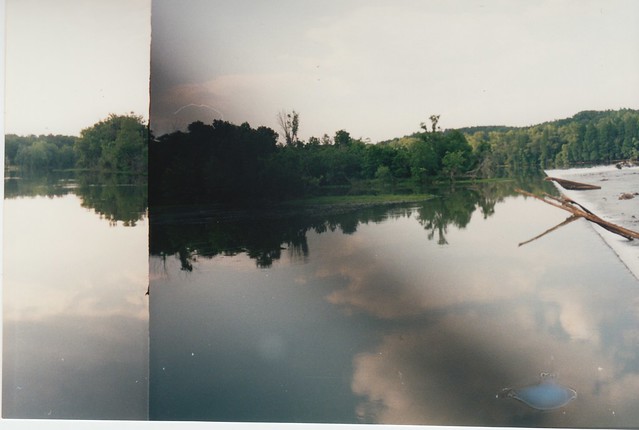
Here's a slideshow from the Vanport Wetlands natural area, just south of the Portland Expo Center. I'd ridden MAX to the end of the line to get some photos of the Oregon Slough Railroad Bridge (as one does) and I had some time to burn while waiting for the train back. So I figured I'd go take a look at the nearby lake. At first glance it looks like your standard run-of-the-mill wetland area near the Columbia, like Smith & Bybee Lakes, Whitaker Ponds, and many others. While that's basically true, there's an interesting story behind this place and how it got this way.

The first thing to know is that this isn't a regular city park, or even a Metro natural area. Instead, the Port of Portland owns and maintains it. Which is strange because their main business is running the Portland Airport and various shipping terminals, not creating duck habitat. It seems they needed to fill in about 14 acres of wetlands at the airport, so they had to create wetlands elsewhere as mitigation, and thus Vanport Wetlands was born. This is how the US Army Corps of Engineers wetland process works, more or less: They'll generally give you a permit to fill and build on wetlands, so long as you create or maintain some other wetlands elsewhere. The theory is that the new wetlands are supposed to be at least as good as the old ones. I suspect that's often not the reality; certainly the little fenced mitigation areas next to suburban minimalls don't look anything like real wetlands, for instance. I'm not a wetland biologist and I can't speak to how good of a job the Port did here, but at 90 acres the Vanport Wetlands are at least larger than the filled area they're supposed to replace.

Back in 2002, toward the end of the Port's restoration effort, they decided to embrace modern technology and they put up a website about the area, its history, and its future, rather than installing the usual interpretive signs at the lake itself. That website has unfortunately been defunct for several years now, but it turns out that the (usually) trusty Wayback Machine has a copy. So I can fill in a few details about the place's unusual history.

Prior to the wetland restoration project, this site had been home to KGW radio towers since the mid-1920s. A pair of 625' towers stood near the center of today's lake. A nearby creepy-looking multistory transmitter building apparently dated to before the 1948 Vanport Flood, which devastated the once-populated surrounding area. The rest of the tower site was a forest of guywires supporting the two antennas. Less visibly, the towers were connected to a grid of buried copper grounding wires, I suppose in case of thunderstorms or something. All of this had to be removed as part of the restoration project, so it wasn't just a matter of taking down the towers and flooding the place. The towers were toppled in December 2000. It's a shame the one online video clip of the toppling is a pre-YouTube, postage-stamp-sized Windows Media file, but that was the state of the art back then. Frankly, I have no idea how we got by in those days.

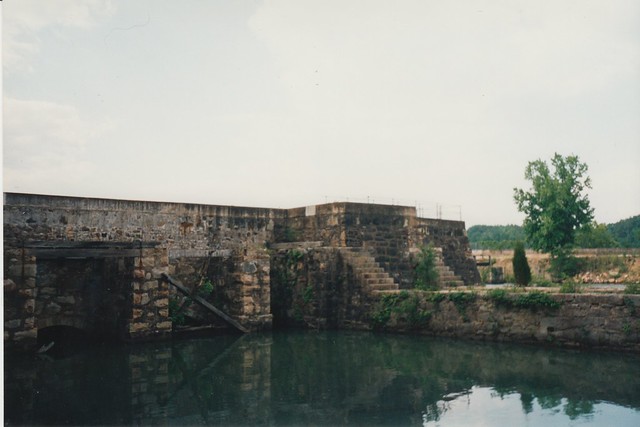
I couldn't get very far during my brief visit because the Vanport Wetlands are surrounded by a chain link fence topped with barbed wire, and the only gate is closed and locked. The old website explains that this is intentional:

Until 2001, access to the site was restricted to a gate on the eastern boundary of the property off N. Expo Road. Following mitigation construction, a second gate, along the northern boundary of the property, was installed. Due to the conservation restrictions placed on the property, there is presently no public access to the site.

A chain-link fence now surrounds the site, with the only vehicle entrance being a gate at the northern end of North Expo Road. Visitors must receive Port of Portland permission to enter the property due to the sensitivity of the wetlands restoration effort underway there. Once native wetland vegetation is firmly established, the Port anticipates some public use of the property for passive recreation and educational activities.

To my untrained eye the wetlands certainly look established at this point, but clearly this maybe-someday public access hasn't come to pass yet. I can see it not being a high priority for the Port; It's not exactly their core business, after all. They do operate a couple of other public parks, though, although none of them are nature areas: McCarthy Park on Swan Island, and the Stanley Park Blocks and much of the Marine Drive Trail near the airport.

The closure may not be that big of a deal, though, since (as far as the general public goes) the Vanport Wetlands are mostly of interest to birdwatchers. If you're serious about birding, you presumably already have gear for observing from a distance -- binoculars, monster telephoto lenses, etc., and I suppose the fence isn't that big of a deal in that case, so long as you can get an unobstructed view over it from somewhere.

The water comes right up to the property line (at least on the east side of the lake), so it's not like they could put in an extensive trail system here, and I think the lake's too shallow for canoes most of the year, but I imagine a boardwalk or observation deck would be doable at some point.

For what it's worth, there seems to be a minor geographic dispute about just what the lake is called. The Port's old website says it's called "Force Lake", but Google and the Friends of Force Lake say the real Force Lake is just northwest of here, on the other side of Force Avenue. Which I think would make this lake Not The Lake You're Looking For. I'm sorry, that was lame and I apologize.

Pics: Beaufort, SC

Here are a few old scanned photos from Beaufort, SC. These few photos don't really give a full picture of the place; taking photos was expensive back in the 90s, and remember 36 shots per roll? Oh, the good old days, or not. The city, or town really, is like a tiny copy of Charleston, SC. You'll be able to see this better once I get around to scanning my Charleston photos. Or you could just Google Charleston; that will work too. Or Bing, I guess. Anyway, we lived in Augusta at the time, about a 2 hour drive inland, and Beaufort was a bit shorter drive than going to Charleston. There's much more to do in Charleston, of course, but Beaufort and nearby beaches were worth an occasional day trip.

The unusual thing about the place is that the surrounding salt marshes often stretch right up to the edge of town. There could be a row of gaudy 19th century mansions, and then what looks like howling wilderness right at the end of the street. I've always liked salt marshes (and you can probably tell that since most of the photos here are salt marshes), so I thought having them next door was a very cool aspect of the town. It may also be a reason Beaufort stayed small though; up until the late 1940s, malaria was still endemic to this part of the South. Living next to a mosquito-filled swamp maybe wasn't always the best plan back then. By the time the threat of disease abated (thanks to a massive federal public health and aerial spraying campaign) the town was old and historic, ready to be rediscovered & preserved for posterity. I hate to say it, but it's possible we have DDT to thank for this quaint little place.


[View Larger Map]

Wednesday, April 02, 2014

Eleven Very Small Sculptures

Not long ago, I dropped by NW Portland's Wallace Park to take some photos of Silver Dawn, the park's big shiny abstract sculpture over near the off-leash dog area. While I was putting that blog post together, I realized the park was home to a second, much smaller sculpture that I didn't notice during the original visit. Or rather, the park was home to a collection of tiny sculptures scattered all about the place, titled Eleven Very Small Sculptures. The RACC page describes it:

Artist: Bill Will, American, born 1951
...
A curious collection of eleven life-size bronze sculptures of common objects can be found tucked away in unexpected places throughout the park. The artist's goal for this piece was to provide artwork that would be subtle and integral to the environment, but would not compete with or obscure the elements that have already made the park an urban oasis.

Will also co-created Street Wise, the whimsical words-in-the-sidewalk thing near Pioneer Place, on the same block as the Human Comedy faces. His website doesn't seem to mention Eleven Very Small Sculptures anywhere; I suppose it counts as one of his minor works, at least size-wise.

I'm afraid I only have photos of one of the very small sculptures here, namely the book attached to a bench near the park's playground. This is because that was the only one of them I could find during a cursory look around the park. The RACC page has photos of several others: A flip-flop attached to a chain link fence (probably at one of the baseball diamonds); a coffee cup and scattered silverware somewhere I can't make out; small objects in the rafters of the park's picnic shelter; sunglasses atop a lamppost; and a milk carton atop a second lamppost. If I'm counting correctly, that comes to ten sculptures, assuming you count each piece of silverware separately. Finding these (and the mysterious eleventh one) is left as an exercise for the reader.

Eye of Orion

Some photos of Eye of Orion, a Manuel Izquierdo piece in the Portland Art Museum's outdoor sculpture court. It's not my favorite among the works of his that I've seen, but at least one random person has been spotted worshipping it, so reasonable people can disagree, I guess.

It also had a cameo role in QR/ART, a 2011 digital exhibition pairing the museum's traditional artworks with online digital remixes through the magic of QR codes. Yeah, QR codes. Which, in 2014, already seems more dated than any of the traditional works on display. What's more, Eye of Orion was paired with a page on weird-fiction.net that now comes up as a 404 (conceptual art not found).

Luckily(?) the Wayback Machine archived the page before it went away. That page turns out to be some incomprehensible yapping about the sculpture's supposed astrological significance. Or something. I"m not entirely sure what the author was getting at, other than the fact that Eye of Orion is somehow Very Very Important to the cosmos at large. Naturally the page mentions the former Masonic temple next door, because of course it would. The archived 'About' and 'Blog' pages are just spammy pages for various erectile dysfunction pills. Overall I'd rate it at about 350 to 400 milli-Timecubes. Maybe the whole thing's supposed to be deliberately loony, Subgenius-style. Or maybe we've found ourselves a second Eye of Orion cultist.

It seems like a dumb thing to start a cult about, if you ask me. I mean, worshiping a tower topped by a great lidless eye, wreathed in flame? Or at least wreathed in sorta-flame-shaped bronze bits? C'mon, guys, it's been done already. There were movies and everything. Although come to think of it, Orion and Sauron have never actually been seen at the same place at the same time, as far as I know. Waiiiit a minute...