Showing posts sorted by relevance for query dalton falls. Sort by date Show all posts

Thursday, September 13, 2007

Somewhere Near Dalton Falls


View Larger Map

Today's scenic adventure takes us to Dalton Falls, out in the Columbia Gorge yet again [map]. Or at least I think this is Dalton Falls. I could be wrong. It's a highly obscure waterfall that doesn't show up on most maps, and there's no road sign announcing it, even though its base is almost right next to the scenic highway. Oh, and did I mention the falls dry up in the summer? Thus driving out to go search for them isn't foolproof either. In short, what you're reading is what I've been able to piece together and deduce so far. Think of it as a progress report. I'm pretty sure I found the right place, or at least the immediate vicinity of the right place, but I always strive for accuracy here and I'd hate to get the facts wrong. So all I'm claiming right now is that I was somewhere near the falls, and "near" is a very flexible word, you know.

The map link above takes you to WikiMapia this time instead of the usual Google Map. WikiMapia be the only map on the interwebs that gives even a rough idea of where the falls are, and the only reason WikiMapia has them is because I added them. I figured out the location with the slick USGS Topo maps at BackCountryMaps. The USGS maps indicate the falls are at "roughly" 45.57088383381129 latitude, -122.14350700378418 longitude. (I don't know how many of those digits are actually significant.) Before anyone complains, yes, the box on the map includes the parking lot, and the lower cascade, but the main falls are just outside the box. I fat-fingered the box when I drew it and now I can't figure out how to resize the damn thing.


Dalton Falls

So here's essentially all the useful info I found on the net about Dalton Falls, and there isn't much of it:

  • The page about Dalton Falls from the Northwest Waterfall Survey is the best source of info I've run across. I'd never even heard of them before running across this page.
  • Here's a fantastic photo of the falls. The same photographer has a large collection of nice waterfall photos here. I know I tend to apologize for the quality of photos here a lot. Sometimes I'm just being modest and I'm secretly kind of proud of them. But this time I really do have to apologize. How about we all agree today's photos serve a purely documentary purpose, since they aren't very artistic, or even all that visually interesting. And this is after going over them with GIMP, trying to mitigate various exposure and color issues and not always succeeding. You'd think it'd be really hard to take a third-rate photo of a frozen waterfall. In my defense, I'm pretty sure there was shivering involved. Taking a nice photo is great, but taking a mediocre photo really fast and getting back inside the warm toasty car is even better, or at least I was quite certain it was at the time.
  • A great page about the Gorge, which includes pics of some "unnamed seasonal waterfalls" in the Gorge. I think some of them are of Dalton Falls, or at least of the place I've rightly or wrongly concluded is Dalton Falls. Others are of Mist Falls, and the falls near the Vista House (which I've seen called "Crown Point Falls" before -- here for example -- although I think it's an unofficial name.)
  • The falls get a quick mention in this excerpt from the 1954 book History of Wasco County, Oregon, by William H. McNeal. McNeal raves on and on about the Gorge.


    SHEPHERD'S DELL [sic] was called "the playground of the fairies!" Bridal Veil Falls has no comparison! Coopey and Dalton Falls would be outstanding in any place as would Eagle's Rest! Waukeena Falls and Multnomah Falls are internationally known! Simon Benson gave them to the state as a park! Multnomah Falls is called "the Queen of all American cataracts;" its drop is 870 feet! Some say, "its too beautiful to be real," others say, "a dream garden falls".
  • OregonWaterfalls.net has a mislabelled photo that's actually of nearby Mist Falls. I'm sure it's Mist Falls, because I've been there, and this is what it looks like. The confusion is understandable, since both falls are very, very obscure, and are just down the road from one another.

Dalton Falls

There's a gravel parking area at the falls. There's no sign saying what the parking is for, so in the summer you tend to get curious people stopping to look around and getting confused. When the falls aren't running you have some high mossy cliffs next to the scenic highway and that's about it. In my Mist Falls piece, I mentioned there was a larger parking lot a short distance west of the tiny one at Mist Falls, and I didn't know what it was for at the time. Then I saw the Waterfalls Northwest piece, and went back through the archives and found a few instances where I took pics of the falls (I think) without knowing they had a name. Or at least, looking back, I'm pretty sure I took the photos in the general vicinity of Dalton Falls. It's been a while, and I could be wrong in a couple of cases. They basically look right, though, so if I'm wrong, I'm not all that wrong.

Dalton Falls

Getting there is like getting to Mist Falls. If you're going east and get to Wahkeena Falls (or Mist Falls for that matter, if you can recognize it), you've gone too far east. If you're going west and see the Angels Rest trailhead parking lot, you're too far east. There's some sort of silver box containing railroad equipment at the parking lot, across the street from where the falls are. I don't know how common these boxes are, there may be others all over as far as I know -- so regard this as a necessary but not sufficient condition for finding the place. I'm afraid I didn't get a pic of the parking lot this time, but you might not need one. Either the falls are flowing, in which case you ought to be able to see 'em from the road, or they aren't flowing, in which case there's really no reason to stop at all, that I'm aware of.

Dalton Falls

As far as I know, the parking lot only gets you access to the base of the falls, which is practically right next to the road. I haven't heard of of any trails going further uphill. If they exist they'd have to be quite steep and thrilling, since you'd likely be hiking them in the winter or spring while the falls are flowing.

Dalton Falls

Updated 1/9/2021: A couple of addenda to this very old post:

  • As I mentioned in a nearly-as-old post in 2008, Dalton Falls is also right next to the old highway's milepost 31 (the post includes a photo of the falls and the milepost, so there's no mistaking it.). So that ought to be a more specific clue than the ones I mentioned above.
  • The Northwest Waterfall Survey page I mentioned earlier (link updated) now explains that the name "Dalton Falls" seems to have originally been applied to a different waterfall on the creek immediately east of Angels Rest, which has since picked up the unofficial name "Foxglove Falls", named after a couple of nearby trails. One possible clue in favor of this theory is that the alluvial fan from that creek extends out into the Columbia as Dalton Point, which we visited back in 2018.
  • Recreating the HCRH expands on that discussion at length and proposes calling the falls shown in this post "New Dalton Falls".
  • A March 2020 WyEast Blog post digs even further into this situation, and proposes names for all the other seasonal falls between Angels Rest and Wahkeena Falls (with included aerial photos of most of them), I guess on the theory that names don't hop around as much if there isn't a vacuum that seems to need filling. The author keeps Dalton Falls on the present-day creek, but splits it into two, Dalton Falls being the tall falls you can see from a distance, and Lower Dalton Falls being the shorter one right up next to the old highway.
  • Per the map from the previous item, I think the creek that's home to "Cordial Falls" (the next one west of Dalton) is the same one ODOT called "Mosquito Springs Creek" in a recent press release about a landslide. And west of there by a watershed or two, I think one of the more minor spots he just called "Falls" may be the canyoneering location known as "Devil's Whisper".
  • Complicating matters slightly more, there is actually an officially-named Dalton Creek nearby, but it's a minor tributary of Young Creek, which then flows northwest and forms the falls at Shepperds Dell. The USGS coordinates for the creek are due south of the east-of-Angels-Rest creek, so my personal theory is that a data entry error may have crept into the USGS database, either for the 1986 database entry or the 1964 state map it's based on. Just changing the latitude of the official 'source' coordinates from 45.525N to 45.565N moves that point to almost right on the rim of the watershed for that creek. On the other hand, the mysterious "W. Dalton" who's believed to be the namesake of all these places might have been enough of a local bigwig at the time that several unconnected places were named for him or her.
  • The naming situation is much clearer for the rocky overhang the falls go over, as it turns out this is a popular local rock climbing spot known as "The Rat Cave". So if you can't find the milepost for whatever reason, like maybe someone stole it to sell on eBay or something, but you do see the overhang, and there's climbing hardware attached to the underside of the overhang (like in this OregonHikers thread), that could be yet another a clue that you're in the right place.
Dalton Falls

Dalton Falls

Wednesday, January 02, 2008

Winter at Dalton Falls

A few photos of icy Dalton Falls, out in the Columbia Gorge, taken earlier this morning. If you've never heard of Dalton Falls (and most people haven't), you might want to check out an earlier post of mine here, which is where I keep my slim supply of useful info about the place.

Driving out there this morning was only a moderately bad idea, as it turns out. It's not true, strictly speaking, that many Bothans died to bring you this information. There was a bit of sleet coming down now and then, but mostly it was just very cold rain, so that was ok, I guess. I came across the site of an earlier accident on the Gorge highway, but the tow truck had it cleared within minutes of when I got there, and I didn't have to wait long. So that was ok too, or at least it was for me. And the falls were running for once and properly iced up, just as I'd hoped, and some of the photos turned out reasonably ok, or at least semi-fixable in GIMP. (I took a few more with the old Spotmatic, so we'll see how those come out when I have the film developed.) After taking these pics, I then had to scurry back into town for an important meeting with the PHBs. I almost missed it, but didn't, so that was ok as well -- although all things considered, I think I'd rather take "semi-fixable in GIMP" photos in 33-degree sleet than talk to a bunch of clueless PHBs again. All in all, nothing terrible happened this time around. Although I should point out before anyone else does that deliberately driving out to the Gorge while a winter storm watch is in effect is really sort of sub-brilliant. And the drive wasn't my idea of a good time, exactly. Wasn't much fun at all, actually. Yech.

Dalton Falls

Now that I'm here in my nice, toasty cubicle, with nice, toasty interweb access, I see that oil now costs over $100/barrel. I'm not even going to speculate about a dollar value on this morning's little foray, but under the circumstances I probably won't make a weekly habit of it.

Dalton Falls

There's another recent photo of the falls (albeit without ice) in this OregonHikers thread. One commenter actually links to my Dalton Falls post as a source of good info, which just goes to show how scarce authoritative info is about the place.

Dalton Falls

For future reference, the falls are just uphill from milepost 31 (above) on the old Columbia Gorge highway. If you find the milepost and don't see a waterfall directly uphill, the waterfall's gone dry and you'll need to come back some other time.

Dalton Falls

Dalton Falls

Dalton Falls

Above & below, a couple of variations on a "wintry grimness" theme, at the mini-parking lot for the falls. You'd almost think I'd been to art school or something.

Dalton Falls

Dalton Falls

The falls from inside a nice, warm car.

Dalton Falls

Tuesday, August 27, 2024

Foxglove Falls

Next up we're taking a peek (albeit not a very close peek) at the Columbia Gorge's Foxglove Falls. This is the waterfall you can see looking east from the top of Angels Rest, tumbling down the far wall of the deep canyon on that side of the viewpoint. I think it's right about here on the state LIDAR map. The canyon is due to Dalton Creek, which we've visited a couple of times downstream in the Dalton Point and Old Boneyard Road posts, and we were in the vicinity of in the Backstrand Road post. The creek is just not very big, and just goes to show what a little water can do to solid rock (albeit relatively weak and crumbly solid rock) over geological time.

As far as I know the Angels Rest viewpoint is the closest mere mortals can get to it without advanced technical gear and skills that I don't have. Although way back in 1918 there was a short-lived proposal to turn the whole Angels Rest area into a private tourist attraction, complete with pack mule trail rides just like at the Grand Canyon, promising great views of the hanging gardens above Dalton Creek among other things. That obviously never panned out, and I'm not sure how serious of an idea it ever was, as the proposal was just one of a series of real estate and stock schemes that had played out over the previous few years. The most serious of these plans involved the backers laying their grubby hands on the bankrupt woolen mill at Pendleton, relocating it to a new company town right at Wahkeena Falls (then known as "Gordon Falls"), damming Wahkeena Creek to power the mill, and Dalton Creek to supply water to Gordon Falls City (the future great metropolis of the western Gorge) and of course selling a bunch of unregulated stock to finance this exciting new 100% guaranteed goldmine. Except that the deal fell through when local interests in Pendleton bought the woolen mill instead, and shareholders in the Gordon Falls Co. lost every cent of their money overnight. It was never clarified whether the backers knew this was about to happen, but they somehow managed to hold onto the land after the company cratered and soon tried a few other moneymaking schemes continuing into the 1920s, like the pack mule adventure park, and at least one proposal to build mansions all over the top of Angels Rest, before eventually losing the land over unpaid taxes during the Depression.

If you're wondering why the waterfall isn't called "Dalton Falls", after the creek, I'm afraid it's a long story. There was a minor local internet controversy about this back in the mid-2000s, and like most internet controversies it was never really resolved to anyone's satisfaction. The name currently applies to a prominent seasonal waterfall on a different creek just west of Mist Falls (and right around HCRH Milepost 31), which we've visited a couple of times, here and here. A theory gained currency that this mismatch was a fairly recent mistake, either by uninformed people on the early internet, possibly echoing a misguided guidebook author or two in the 1970s, 80s, or 90s. The name and location of the creek (and its mouth at Dalton Point) were pretty well documented, thanks to various surveys and property records, so (the idea went) the real Dalton Falls should be somewhere around here too.

Eventually people settled on the waterfall below (and semi-glimpse-able from) Angels Rest as the most likely candidate, the theory being that it was probably named not long after the area was logged, and it would have been a lot more prominent back then. And I think that's the explanation I've repeated here a few times. But then the Eagle Creek Fire happened, and that made Foxglove Falls much easier to see from the Angels Rest viewpoint (like in the photos here), and closer to what people would have seen a century ago. But it still isn't a prominent sight from down on the old highway. So now I'm not really sure anymore. As in, maybe the creek and the falls were always in different watersheds, a testament to the once-widespread fame of the mysterious W. Dalton they're both named for. The name seems to have existed already when the old highway was still under construction, so maybe the falls are a lot more prominent when seen from further away, like on a steamboat heading upriver (for example), than they are from the HCRH. That's certainly true for Mist Falls as well as the "Dalton Falls" at milepost 31, where up close you can only see the very lowest tier of the falls. But then, making an accurate, detailed map from a steamboat was subject to its own hazards back then, like having a bourbon or three too many, losing all your money playing cards with a friendly gentleman named after a state (or even worse, two states, like "Colorado Tex"), and then the friendly ladies wearing all those feathers abruptly stop paying attention to you after you run out of silver dollars. Why, it's enough to make a mild-mannered cartographer scribble "Dalton Falls" on just any old place, and we've been stuck with it ever since.

This whole thing would've been helped immeasurably if anyone had thought to make a clearly labeled set of daguerreotypes of second-tier Gorge landmarks back in the day, but no examples of that have surfaced so far. Barring that, the other thing that would resolve this pretty quickly would be newly-discovered evidence that W. Dalton was some kind of monster and needed cancelling. Like maybe he came west while on the run from charges back home in Alabama, where he was accused of mistreating his many, many slaves. Or something along those lines. And as a result every last thing that might have been named after him, here and across the northwest, would have to be renamed.

Meanwhile the name "Foxglove Falls" is relatively recent, originating in a 2007 OregonHikers thread as a way to sidestep arguments about various things named Dalton. It featured in a number of forum threads there after the name was invented:

It also has a Northwest Waterfall Survey page now, and generally seems pretty established at this point. The page wisely doesn't hazard a guess as to how tall it might be; the LIDAR link up above points at what looks like the most prominent single drop in a series of closely spaced drops, each in the 20'-40' range, with the creek rushing steeply downhill between them, and at one end of the scale you could point at the one bit I think I have photos of, which might be in the 40' range. Lumping them together with the top here and the bottom here gives a total height of 220', while pulling in everything from the very top to the point where all four main tributary creeks join together here comes to 436', almost exactly 11x as tall as the low-end number. So that's not especially useful, as vital statistics go.

Regarding the new namesake: Foxglove is not native to the Pacific Northwest, but you may see it growing as an invasive plant in the Angels Rest area. It seems that decades ago, someone involved in building or maintaining the unofficial trail network above Angels Rest was also an amateur gardener, and as this was before the modern environmental movement got going, it seemed like a good idea at the time to combine two hobbies and improve the forest with some of their favorite ornamental plants, and then name a few of the trails after what's planted along them. So until quite recently there were three trails named Foxglove (Foxglove Way, along with the Upper and Lower Foxglove Trails), and a steep, rocky Primrose Path that apparently needed a re-primrosing on a fairly regular basis, and I think a couple of other plant-themed ones whose names escape me at the moment.

Sometime around January 2022, another anonymous individual decided three trails was entirely too many Foxgloves and unilaterally renamed a couple of them. Renamed them in the OregonHikers Field Guide wiki, and on OpenStreetMap, and even posted freshly-made hand-carved wooden signs at all of the affected trail junctions, replacing the few decades-old ones that had survived the Eagle Creek Fire. Whether you like the change or not, you have to respect that level of dedication.

Tuesday, August 21, 2007

Mist Falls


View Larger Map

Today's adventure takes us to Mist Falls [map], out in the Columbia Gorge -- although "Mystery Falls" might be a better name for it. It's just down the road from Multnomah, Wahkeena, and all the others, and by all accounts, it's the second-highest waterfall there after Multnomah (although sources disagree on just how tall it actually is). For all that, almost nobody knows it’s there. It doesn’t have a large official sign at the trailhead like the others do. It doesn’t even appear on many maps of the area. If you've read this blog before, you know I can't resist a mystery like that. I'm going to wonder why, and keep wondering, and not be able to rest until I find out, because that's just how I am.

I’d vaguely heard of Mist Falls before, since it's mentioned in the print and online versions of the Waterfall Lover's Guide to the Pacific Northwest, but the guide doesn't tell you exactly where it is, or what it looks like, and for some reason rates it a mere one star, down in the "not worth turning your head to see" category. Then when I was digging around for info for Monday's gorge waterfall post, I ran across more info about the falls, and I just had to go find the place.

The crib note version of the falls: They're just west of Wahkeena Falls, are as much as 500 feet high, and do, in fact, run year-round, despite popular misconceptions to the contrary. And there's a trail up to the base of the falls, although the trail's hard to find, and difficult to navigate once you find it.

I figured I'd start out with a link dump about the falls. I researched the place on the net before setting out, so doing a link dump first is sort of going in chronological order. (Don't worry, there's more pics after the link farm. I don't really like how the waterfall pics are bunched up towards the bottom of the page, but that's how the piece wrote itself. If you just want to look at more photos, the scrolly wheel is your friend.)


  • Waterfalls of the Pacific Northwest describes the falls in various places as either 400 or 500 feet tall. I'm terrible at guessing heights, so either sounds reasonable to me. This site is where I figured out where the falls were, and learned there was a trail. Well, a kinda-sorta trail. We'll get to that part in a bit.
  • Lewis and Clark's Columbia River has several good photos, along with (naturally) excerpts of Lewis & Clark's journals as they explored the area.
  • A great photo of the falls, taken from across the Columbia. Presumably with a much more expensive camera and lens than I've got.
  • Ash Creek Images has a nice photo of Mist Creek and the base of the falls. It's just one of several pics of the area at that site.
  • Another photo, although the caption claims the falls are inaccessible and seasonal, neither of which is precisely true, technically speaking.
  • The Salem Public Library has an old photo of the falls. The exact date is unknown, but it's from somewhere in the 1879-1909 timeframe.
  • Yet another photo, this time mislabelled as Dalton Falls, another obscure waterfall due west of here. This is the sort of confusion that occurs when you don't put up signs and so forth.
  • The World Waterfall Database describes the falls as:

    This is one of the tallest waterfall in Oregon State, however, due to the creek's small drainage area, they are not very appreciated. The falls usually retain some volume throughout the year, however, they do run almost dry in the late summer, and may dry out in drought years.

    Fortunately(?) this year is anything but a drought year. I don't think they'll be anywhere close to running dry this year.
  • The falls were mentioned during the Congressional hearings that led to the present-day National Scenic Area:

    The timbered lands below Mist Falls, which is over 1000 feet high and which borders the highway, were sold for $7 and $8 an acre -- and logged.

    A thousand feet high. Wow. Well, Congress wouldn't lie to you, would they?
  • A 1907 issue of Mazama magazine gave the same figure. You'd think the Mazamas would have their numbers straight, but I suppose people weren't so big on precision a century ago. They just rounded up to the next-greater order of magnitude and called it good, I guess.

    Unless the falls really are a thousand feet high, and modern sources are wrong. I doubt that's the case, but if people wanted to believe Multnomah's the tallest, not some obscure interloper to the west, I can see how it'd be easy to overlook certain inconvenient facts. There's probably a really great conspiracy theory in this somewhere.
  • Oh, but it gets better. In 1940's Oregon: End of the Trail, the Federal Writers' Project described the falls thusly:

    MIST FALLS, 159.8 m., where the water drops from a 1,200 foot escarpment were thus mentioned by Lewis and Clark: "Down from these heights frequently descend the most beautiful cascades, one of which [now Multnomah Falls] throws itself over a perpendicular rock. . . . while other smaller streams precipitate themselves from a still greater elevation, and evaporating in mist, again collect and form a second cascade before they reach the bottom of the rocks."
  • And that's not all. An old guidebook by the California Automobile Association describes Mist Falls:

    Then comes Mist Falls, where a great body of water is driven to near-nothingness before it reaches the bottom of a cliff, 1500 feet below.

    1500 feet. Golly.
  • A 1916 Oregonian story by one Eva Emery Dye declined to estimate the falls' height, but waxed poetic about Mist Falls and its neighbors:

    A mile east of Shepperd's Dell, the Bridal Veil shimmers like the Staubbach, the Dust-brook of Switzerland, and three miles more, Mist Falls leaps like Nuuanu stream back of Honolulu, to be dissipated and blown into space long before reaching the waters below.

    Out of Punchbowl Crater, 1300 feet deep, springs Wahkeena, full panoplied like Minerva springing from the head of Jove, winged with foam and bubbles, cutting huge gorges on its way to the Columbia, a roaring cataract, tumbling, foaming, spouting icy-cold as the underground glacier in which it has its birth.

    People just don't write like that anymore. Certainly the newspapers never do. Possibly that's for the best.
  • The Virtual Tourist mentions the falls on its Off the Beaten Path Multnomah Falls page. Usually lists that use the phrase "off the beaten path" are anything but, so I'm pretty impressed to see Mist Falls on the list.
  • Another great page full of info at OregonHikers, along with one reader's report, "After work to Mist Falls", with a bunch of great photos and a detailed writeup about the trail. That report is what really made me want to find the place ASAP.

Mist Falls

So this is the unmarked trailhead to the falls. This was taken heading east on the old Gorge Highway. Like all the instructions say, if you get to Wahkeena Falls you've missed it and you'll need to turn around and go back. There's also a larger pullout further west, so it's also possible to pull off the road too early. I'm not sure what the other pullout is for; I stopped and looked around but didn't see anything interesting. In any case, if it doesn't look like this, you're in the wrong place.

Mist Falls

Off to the left, across the highway from the mini-parking lot, are railroad tracks and a lake the maps just call "Fish Rearing Pond". If there's no lake across the street, you're in the wrong place.

Mist Falls

So here's the trailhead itself. As you can see, it's pretty overgrown and unmaintained, and this is the good part of the trail. It's all uphill from here. If you look at the photo with the road, the trailhead is near the center, between the parking lot and the highway. If you look at that pic on Flickr, I've added a couple of notes showing the location of a few key things.

Mist Falls

This little plaque is one of the key things I mentioned. If you see this, just a few feet from the start of the trail, you know you're in the right place. For those troglodytes out there who still use Lynx or have "load images" turned off, the caption reads:
THE PEOPLE OF OREGON HEREBY EXPRESS THEIR GRATITUDE TO ROSE M. LENSKE FOR THE DONATION OF THIS FIVE ACRE TRACT OF LAND FOR PARK PURPOSES -------- OREGON STATE HIGHWAY COMMISSION 1971
So apparently Mist Falls is actually a super-obscure state park. Coolness. Tracking down obscure parks is another weird mini-hobby of mine, so Mist Falls counts as a twofer. So who was Rose Lenske, and what's the deal with the rock walls around here?

This page at Ash Creek Photo tells the story. There was a hotel here called "Multnomah Lodge" from 1916 up until the 1950s, and the rock walls were part of it. I haven't found a lot of info about the lodge -- it's a matter of finding it within the mountain of info about present-day Multnomah Falls Lodge. I did run across a 1916 mention of the lodge and the falls, in a state publication titled "The Mineral Resources of Oregon":
Multnomah Lodge is three and one half miles beyond Bridal Veil, a delightful hostelry, where visitors find both cheer and the fullest satisfaction of ordinary physical needs. Mist falls is a mere filament of water, so slender that before half of its sheer drop of near a thousand feet is made, it is none else than a spray of mist—hence its name.

The Ash Creek piece mentions Rose Lenske's "colorful" husband Reuben, linking to a juicy Willamette Week story about a fight over his estate. Kind of entertaining, although a bit off topic. The lodge's old fireplace is supposed to be around here somewhere (another photo here), but I wasn't able to find it, try as I might. I looked all around and didn't see it, but then, my powers of observation aren't always the best. Maybe I'll have to go back and look again or something. Back in January 2001, the Columbia Gorge Commission discussed removing the plaque, as it apparently doesn't meet their present-day criteria for memorials in the area. They must've changed their minds, though. The plaque is still there, and even looks like it's been cleaned recently.

Mist Falls

Another remaining sign of the old lodge is this cover over a storm drain on the highway, next to the trailhead.

Mist Falls

If you stand directly on the drain cover and look uphill, you can catch a glimpse of the top of the falls, as shown here. You can't actually see the upper span of the falls when you're closer to it, so you'll need to do this to really get the full experience. Actually the view's slightly better if you stand in the street, but Legal says I can't advise you to do that.

Mist Falls

So here's part of the actual trail. It doesn't give a good idea of just how steep it is, but you're clambering straight up a loose talus slope. It's not so much a trail as a climbable rockpile. This is the open part of the trail; other parts are equally steep but hemmed in with bushes. I didn't take too many photos on the trail, and most of them came out on the blurry side. You can't see the falls during the first segment of the hike. After the open slope you get to a large rock. If you thread yourself between the rock and the drop to the creek, you'll finally catch your first good glimpse of it:

Mist Falls

And if you turn around, the view out over the Columbia is pretty good too:

Mist Falls

Keep forging ahead, and you'll get to the base of the falls eventually. It's not a long trail, but it can be slow going, and why hurry, after all?

Mist Falls

Mist Falls

There are even a few flowers. You didn't really think I'd get through a whole post without any flowers, did you?

Mist Falls

So why is the place so obscure? Why aren't there any signs -- for the falls, the trail, the state park (whatever it's called)? Why is the only trail an unmaintained use path? Why all this, when the other falls along the highway all have first class visitor facilities? I have a few theories:

First off, many of the sites that bother to mention the falls at all give a disclaimer that there isn't a lot of water, even though there was when I visited. Possibly it does go dry in dryer years, or possibly it's just a meme that goes around. Interestingly, the older mentions of the falls don't give the low-volume disclaimer. Was there more water once? Global warming, perhaps?

So some people think the falls fail to impress because of their lower volume. I don't buy that, myself. Any amount of water falling 500 (or 400, or 1500) feet is innately impressive, especially in this setting. I gather waterfall purists (and they do exist) turn up their noses at anything that goes dry, or nearly dry, in the summer. Even if Mist Falls did dry up in the summer like nearby Dalton Falls , so what? Then you'd just want to visit some other time of the year. If it's flowing while you're there, why do you really care whether it dries up for a few weeks six months down the road? Silly purists. Feh.

Second, the present trail is really freakin' steep and narrow, and can be scary when wet. The trails at other falls around the gorge are pretty newbie-friendly, so if you just put up a big sign and didn't change the trail, there'd be trouble. At Multnomah Falls it's not uncommon to see people strolling up the trail, latte in one hand, the leash of an exitable Lab puppy in the other, yapping away to their broker or somebody on their hands-free Bluetooth headset, utterly oblivious to their surroundings. Try doing that on the Mist Falls trail and you're in for a rude and possibly painful surprise.

I'm sure they could put in switchbacks, stable surfaces, handrails and such. Building trails isn't rocket science. It's just a simple matter of throwing enough money at the problem. Unfortunately, since the state owns the land, finding said money would be an epic adventure. For all I know, Mist Falls has been in the pending queue for improvements since 1971, waiting for funds to become available someday. It wouldn't really be fair of me to make fun of the state for not having any money. Still a real shame, though.

Third, obscurity breeds obscurity. If you don't know the falls are there, you don't visit, and you don't lobby for or make improvements. If all the other falls have nice amenities, and this one doesn't, you naturally assume there's a good reason, and it's not worth fussing over the place.

Much of today's infrastructure in the gorge still dates back to the building of the Gorge Highway or shortly thereafter. At that time, and until 1971, the Mist Falls area was in private hands and so didn't get all the fancy stonework and trail engineering and such that the others got. Mist Falls wasn't in line when the goodies were handed out, nearly a century ago, and there hasn't been a second round of handing out goodies, so therefore it doesn't have them. Thus illustrating why it's good to get it right the first time, because you never know if or when you'll get another chance.

Sunday, August 29, 2021

Backstrand Road, and a small mystery

As I think I've mentioned once or twice now, one of my coping strategies during the ongoing pandemic has been to get outside when I can, while encountering as few other people as possible, ideally nobody at all. It's not just about avoiding getting sick; I've had all my shots, and will get my booster when it's available, and I've seen all the (pre-Delta) studies that say the odds of catching Covid outdoors is very low, especially if you're just passing someone on a trail for a few seconds. But people still stress me out, even knowing all of that. I also figure that even if I'm overreacting -- and I probably am, even with the Delta variant on the loose -- it's still an excuse to spend way too much time staring at maps and looking for the most obscure, least visited places I can come up with, which is a big part of the fun.

So a while back I ran across the US Forest Service Interactive Visitor Map and started poking around the Columbia Gorge on it, as one does. The key thing here is that this map shows Forest Service roads as well as trails, and a lot of these roads are either gated and closed to motor vehicles, or get so little traffic that they effectively count as trails. The downside is that they often don't go anywhere interesting, and just end in the middle of the forest at the site of an old 1960s clear cut, or power lines, or a cell tower, that sort of thing.

While staring at that map I noticed a couple of short forest roads branching right off the old Columbia River Highway just east of Bridal Veil, smack dab in the middle of the main tourist corridor, and I'd never heard of either of them. So those obviously went on the big TODO list, and now you're reading a post about one of them.

So right around the pushpin on the map above, roughly halfway between the Angels Rest trailhead and Wahkeena Falls, there's a small turnout off the eastbound side of the old highway, with a closed and dented gate and no obvious signage visible from the street. If you're like most people, you probably won't notice it at all, and if you do you'll probably assume it's private property of some sort, since that's exactly what it looks like. It sure doesn't look like a trailhead, at any rate. But this gate belongs to you, the federal taxpayer, and behind it is an old road the Forest Service calls "Backstrand Road", aka road number 3000-303. Past the gate, the road heads steeply uphill for a bit -- a back-of-the-envelope calculation and some guesswork says it's a 10% grade, within a few orders of magnitude or so -- and it then turns right/west at a corner with some old decorative rockwork, then widens and levels out for a short stretch, before petering out into dense underbrush.

At the corner where the road levels out, you can clearly see where the road once continued east as well, and a current county assessor's map shows that bit of road heading back down to the highway at a more reasonable angle. But that road has also been thoroughly consumed by the forest and you can't make any progress on foot in that direction either. So that's about all there is to do here. I didn't see any obvious side trails or other attractions. Glimpses through the trees suggest there'd be a decent view from the top of the trail if it wasn't for all the trees, but there are zero breaks in the trees so that's kind of a moot point.

So given all of that it's not surprising that a 2003 Forest Service roads assesment and its 2015 update both labeled the road as "low value" and recommended it as a high priority for decommissioning. But the reports also noted that the road wasn't a significant risk to anything or anyone if it was just left the way it is now. Which is probably why they still haven't gotten around to ripping it up in 2021. But why was the road here in the first place?

To me the road really doesn't look like your ordinary Forest Service logging road, even in its now-overgrown state. It just seemed like someone spent more money on it than the USFS likes to spend on logging roads. So I did a little digging and apparently this was private property with a house on it just twenty years ago. I know this because of four data points:

  • The PortlandMaps entry for 49666 (!) E. Historic Columbia River Highway (the honest-to-goodness street address of the lot containing the road) has a last-sale date of 2001, and the assessor history shows that property taxes were being paid on the land before that sale, which tells us it was private property just 20 years ago. The entry also says the 27.36 acre lot is still technically zoned as residential.
  • The road appears in 1961 and 1995 county survey records, the latter looking much like the current road layout. A comment on the 1995 survey refers to the road as a "driveway".
  • The Multnomah County surveyor site also has a neat feature with aerial imagery taken periodically since 1998, which unfortunately I don't see a way to link to directly. The 1998 and 2002 image sets show a structure at the west end of the flat bit of road, while the 2004 edition shows fresh dirt where that structure was, and the latest edition shows nothing as the forest canopy has now grown in by a lot.
  • I also managed to find some info about the former building, thanks to whoever had the brain-genius idea to auto-generate a "real estate listing" page for every street address in every dataset they could lay hands on, including obsolete stuff. The resulting pages are just search result-clogging SEO spam upwards of 99% of the time, but the listing for this place tells us the long-gone house was 974 square feet, built in 1958, with one bedroom, one fireplace, and baseboard heat.
I unfortunately couldn't find any news stories about the sale here. I suppose there either wasn't a press release at the time, or there was but nobody deemed it newsworthy.

That's not a very interesting story by itself, but there's a bit more history around here, and for that we have to zoom out a little. The state LIDAR map shows what kind of looks like a faint trail or service road or something heading west from where the house used to be, heading toward Dalton Creek.

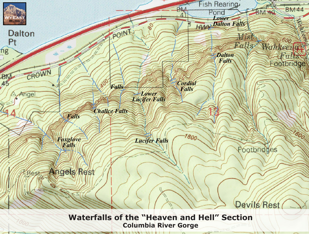
Now, Dalton Creek was the subject of several OregonHikers forum threads, mostly in the late 2000s and early 2010s, several of them trip reports from people trying to sort out the "which waterfall is Dalton Falls" controversy (see my old Dalton Falls posts for more on that) and looking for additional falls on a few creeks immediately east of Angels Rest:

There were a couple of mentions of bushwhacking along Dalton Creek up from the old highway and sometimes climing all the way to Angels Rest from there, so apparently nobody realized there was a simpler and less thorny way to do the initial approach, a way that also skips traipsing along right past someone's house.

Dalton Creek is also the property line betwen the Backstrand Road property and a pair of small lots with diagonal property lines that together form a rough diamond shape totaling about 10 acres. Those property records show the Forest Service has only owned them since May 2002, and whoever owned them before was exempt from paying taxes on the land, so either another government body or some nonprofit group. I'm not positive I've found any news about that sale either, but I did find an April 2002 article that briefly mentions a possible upcoming land deal somewhere in the Bridal Veil area. It says the sale would cover 77 acres & could enable an ADA-compatible trail to Bridal Veil Falls someday, so it may be about a completely different land deal, or it might have covered the lots here and others elsewhere. The timing seems right, but there just aren't enough details to be sure.

Which brings us to the small mystery from the title of this post. A 1962 zoning map and an earlier 1950s tax assessor's map both label the diamond-shaped area as "YMCA". That got my attention, and before long I thought I had it all figured out: An April 1919 Oregonian story explained that local farmer George Shepperd (famous as the donor behind Shepperds Dell State Park) had also donated a house and land somewhere in the Bridal Veil area for a new YMCA camp. A WyeastBlog post about the nearby Bridal Veil Cemetery gives some backstory on Shepperd, his YMCA donation, and a series of strange and melancholy events in the years after he donated the falls. The trouble was that I couldn't find any subsequent news stories about the camp -- no grand tour when it opened, no vintage photos of kids doing crafts, nothing -- and a 1927 Metsker map doesn't show a YMCA camp here, or even any property lines corresponding to the camp we saw on the 1950s & 60s maps. Instead, it shows that roughly the entire area beyond the old mill town was then owned by a "Columbia Highlands Co.", including the Backstrand Road property, the future YMCA diamond, and points east all the way to Wahkeena Falls.

(Incidentally the other (and the oldest) ownership map I ran across was from 1889, and shows the whole area owned by a W. Dalton, who we met but learned nothing about in one of my old Dalton Falls posts, or maybe the Dalton Point one. He or she also doesn't figure into the present story any further, other than being the namesake of the creek here.)

Anyway, the Columbia Highlands company was incorporated in July 1915, and a brief business item the day after the big announcement noted it was capitalized at $400k and would be "a general brokerage firm dealing in real estate". Another item the following month finally explained what the company had in mind:

The Columbia Highlands Company was given permission last week by the state corporation department to plat and sell approximately 1760 acres of land along the Columbia River Highway, about 30 miles from Portland, and to construct a scenic road, clubhouse, and hotels. The company is capitalized for about $400,000, and its officers are Portlanders.
A similar Oregon Journal item also explained that the company is a consolidation of the interests of the Gordon Falls company, Charles Coopey, and Minnie Franklin.

Those names got my attention, and let me try to explain why briefly. "Gordon Falls" is an old name for Wahkeena Falls, Coopey was one of that company's founders (and namesake of Coopey Falls along the Angels Rest trail), and Franklin was the future Mrs. Charles Coopey, and the full story of the company is a whole other half-finished draft blog post I need to finish, but the short version is that the company proposed to build a woolen mill somewhere near Wahkeena Falls, to by powered by damming the creek above the falls. The mill would of course have its own company town nearby, to be named "Gordon Falls City", whose water supply would come from diverting Dalton Creek right here. It turned out the plan was not to build a new mill from scratch; instead the new mill would be a relocation of the famous woolen mill at Pendleton (which still exists today), disassembled and shipped west piece by piece. The whole scheme sounds outlandish, and it came to nothing when locals in Pendleton passed the hat and outbid the Gordon Falls investors, and found someone in town who was willing to take over the recently-closed mill. Which may have been the real plan the entire time, and the Gordon Falls City scheme was just a ruse to scare Pendleton into paying up. In any event, the company's stock was instantly worthless, and Portland-area investors who lost everything were outraged, and the whole mess ended up in court for years and years afterward.

The company's only real asset was all the land it had accumulated between Bridal Veil and Wahkeena Falls. Under modern bankruptcy law that land would go to pay off Gordon Falls creditors, but back then it just sort of quietly rolled over into the new Columbia Highlands company, just in time to try to cash in on the brand-new Columbia River highway next door. A May 1916 story announced the new business plan was to subdivide the company's holdings for summer homes and general development. The company's land extended way up into the hills and canyons above Bridal Veil, and in some alternate timeline where this plan panned out there are endless historic preservation battles around a cluster of fabulous but decaying Gatsby-like Art Deco mansions atop Angels Rest, which have proved to be prohibitively expensive to own and maintain. In our timeline, a pair of Journal stories from July 1916 note that part of the company's now-1700 acres had been surveyed and platted as residential property, and they had already sold a pair of lots totalling 2.5 acres with a prime view of (newly renamed) Wahkeena Falls, with home construction to begin shortly. Typically an item like this would be the kickoff for a long stretch of weekly or even daily real estate ads touting the area and reminding the reader that the area will be sold out soon and this may be their last chance to own a piece of the Gorge. But I couldn't find any sign that they had ever advertised Columbia Highlands, unless maybe the ads neglected to use the key phrase "Columbia Highlands", or the words were in an overly ornate Deco font that the newspaper database's OCR system couldn't parse. And what's more the Multnomah County Surveyor's Office GIS map has no trace of any of this alleged subdividing and platting ever being filed with the county, so it's anyone's guess what was really going on here. In any event, the next mention I found of the scheme was an August 1918 news item suggesting the company had changed plans again:

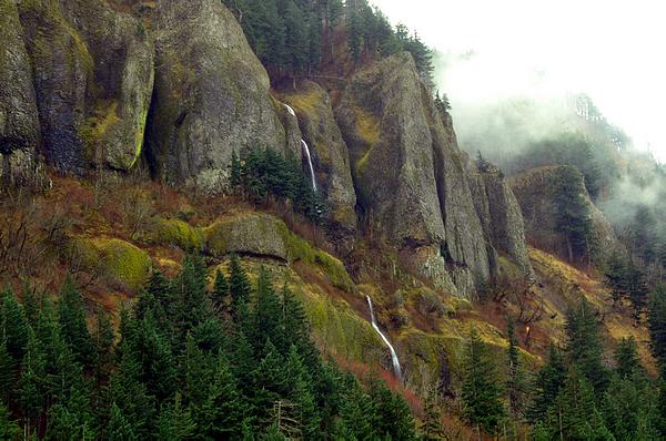
Following the annual meeting of the Columbia Highlands Company, held yesterday, it is announced that the directors have decided to carry forward a plan of development of their property through which the Columbia River Highway runs for nearly three miles. Trails will be developed to various scenic points, including the hanging gardens on Dalton Creek and numerous grottoes of exceptional scenic beauty. Attention will be given to lands adjacent to the highway, and steps will be taken to protect the shrubs, trees, and forest from the vandalism of thoughtless visitors.

A similar Oregon Journal article explained that the company was now just going to develop land along the highway, with the balance reserved as a privately-run tourist attraction. Hiking trails would come first, followed eventually by longer trips up into the mountains by burro or pack mule, I suppose along the lines of what you can still do at the Grand Canyon. The new board of directors listed a local judge as president of the firm, the other seats filled by familiar names, including Coopey as secretary, and Coopey's wife as treasurer. I'm reading between the lines here, but I wonder whether Coopey's presence on the board and long bitter memories of the woolen mill scheme were a hindrance to the Columbia Highlands operation, and they brought in a respectable outsider to be the public face of the struggling project going forward.

There is almost no further news about the company after that. A1922 public notice from the Secretary of State's office listed it among a large number of companies that had not maintained a current business license, or paid any fees, or made any required filings with the state over the past two years and were hereby officially dissolved. After that, the very last we see or hear of the company is a 1933 business item simply listing it under "dissolutions", with no indication of what happened during the intervening eleven years, other than the company name being all over that 1927 map. Did the 1922 notice finally get the attention of the company's lazy lawyers, who went back through the company's unopened mail pile and found the relevant "final notice" letters and somehow got back in the state's good graces? Did the dissolution order get tied up in an endless court case for a decade and change, without making the newspapers at any point? Or did various authorities just neglect to follow up on the 1922 order for all that time? July 1933 would've been during the initial burst of New Deal legislation, as it was becoming abundantly clear that 1920s laissez-faire business was on its way to the dustbin of history; maybe the state or the county figured it was time to tidy up some zombie corporations and other loose ends, before the feds did it for them. I do wish the company had at least managed to build a few of those trails before cratering, since (per the OregonHikers threads above) there still isn't a reasonable way for ordinary hikers to visit the "hanging gardens" along Dalton Creek.

That 1933 item is followed by another eleven-year gap, as we jump forward to the next historical map I could find. The 1944 Metsker map of the area is essentially identical to the 1927 one, but with the former Columbia Highlands properties now owned by a Catherine B. Fairchild, about whom I can find almost no information. The 1927 map showed the name "Fairchild" on a small lot along the highway. And if you look closely at the 1944 map you can see where someone applied whiteout in a few spots, replacing "Columbia Highlands" with the name of the new owner, suggesting this was either a recent development, or the news was slow in reaching the Seattle offices of "Metsker the Map Man"

Other than names on maps, the only news item I could find with a matching name or initials was a 1926 traffic item noted that a Mrs. C.B. Fairchild, of Aberdeen, WA, had broken a few ribs when her car flipped on a gravel road along the Washington Coast. This was part of a long list of traffic accidents and injuries around the region, so if somehow you're ever sent back in time by a century or so you might want to make a note to avoid driving or riding in cars if you can, because it sounds quite dangerous. This item was just below a group photo of the new state Republican committee, which (quite unlike the present day) had 8 female members out of 18 total. You can still tell it's the GOP, though, because the photo is 100% white, and everyone in it is scowling at the camera. Below all the traffic gore and mayhem, another item concerned a lobbying campaign to have a Three Sisters National Monument declared, which still hasn't occurred nearly a century later. The area does get National Park-level visitorship, but still doesn't have a budget or protection level to match. Or at least not yet.

But back to our story, specifically a 1952 front page story. It seems the Fairchild estate had been foreclosed upon a few years earlier for unpaid back taxes, with the land going to Multnomah County. The controversial part was that the county had then sold off large tracts of the land to private buyers -- including 600 acres in the general area we're visiting right now -- without first asking the state parks department whether they wanted any portion of the land. The county seems to have been caught flat-footed by the controversy; the head of the county land office explained that notifying the state wasn't his job, and in general the county preferred to get land back into private hands and back on the tax rolls, and besides they might have mentioned the Gorge land in passing while talking to the state about something else, so it was really the state's fault for dropping the ball. That didn't go over very well, and he ended up promising to notify the state first if any more Gorge properties ended up in county hands. Meanwhile the new owners in the area -- a Mr. & Mrs. Calvin C. Helfrich, an elderly couple who had picked up the property back in 1949 -- had already logged much of their acreage, and were talking about building summer cabins in the area, and had applied for water rights on Dalton Creek, echoing a few parts of the earlier Highlands and woolen mill efforts.

Later in October 1952, the Helfriches -- possibly stung by the recent public outcry and bad press -- donated 30 acres of the property to the YMCA to be used as an Indian Guide camp to be known as "Camp Helfrich". They also gave an adjacent half-mile of highway frontage to one of their sons, but the article doesn't specify in which direction so I don't know whether that included the Backstrand Road property or not. The article notes that both properties were still timbered, unlike much of the surrounding area. So the earlier Shepperd donation turns out to have been a total red herring, and I have no idea what happened to the land from that donation or even where it was, exactly.

Now that I had an actual name for the camp, I figured I could just put "Camp Helfrich" into Google and the library's newspaper database and the rest would be easy, just with a start date of 1952 instead of 1919. And once again I was surprised by how few results came back. First off, we have a 1953 fundraising campaign for the new camp, with a cringey photo of beaming white kids in pretend-Indian garb. And not long afterward, a 1954 classified ad offering the remaining 550 acres for sale at $40/acre. Which sounds like a good deal until you realize the 1949 foreclosure sale had privatized the land at just $8/acre. The ad may have had the desired effect though; it only ran once, and the State Parks department bought most of the land in 1955. 403 acres changed hands this time, including Mist Falls and Angels Rest, but not the land right around the new summer camp. The article doesn't mention what the state ended up paying per acre.

In 1959, a different donor gave $10k to the local Indian Guide program. A YMCA spokesman said they might use some of the money for a new longhouse building. Which, however, would be located at Camp Collins, their much better-known youth camp next to Oxbow Park, and not their supposedly dedicated Indian Guide camp further east, which wasn't mentioned anywhere in the article.

Two small Oregon Journal news items in 1958 and 1963 alerted parents about upcoming summer day camps at Camp Helfrich, along with a whole galaxy of other summer camp options. The 1958 notice said swimming was on the agenda, though it beats the heck out of me where you could put a swimming pool or a pond, or really any part of a summer camp for that matter, in this kind of terrain. Maybe it just wasn't a very good site for a summer camp, I dunno. The 1963 mention is the last newspaper item I could find about the camp, and that's where the historical record (or that portion of it that I can find on the internet for free) just sort of ends. Inconveniently none of the news items about the camp included a map of it or even gave a street address, so I don't even know how people got there from the highway, whether Backstrand Road once doubled as the camp entrance, or if the entrance was somewhere else and it's just been erased so well that there's no trace of it on the LIDAR map anymore.

The really puzzling thing about all of this is the complete lack of Google search results about the camp. That honestly surprised me a lot more than the lack of news items. I figured there would at least be a handmade web page from 2001 about a the place, or an Angelfire or Tripod site, with Boomers waxing nostalgic and swapping memories of their summer camp days, maybe even with a few teen crushes finally hooking up half a century later. But no dice. Then I checked the Wayback Machine in case those pages had been on Geocities or some other long-deleted location; I even checked Facebook in case there's a private FB group out there for camp alumni or former counselors, or just somone posting a photo or mentioning the place in any way, and I don't even like Facebook and trying to do a useful search there is even harder than getting straight answers out of 2021 Google. If nobody's nostalgic about an old summer camp, did the place ever really exist? I'm only mostly joking here. If you just tell everyone that signups are already closed, and the waiting list's full, whenever anyone tries to register their kid or to volunteer, you could probably keep a phantom summer camp on the books for a fair number of years before anyone caught on, or you got bored of the charade. I'm not sure why somebody might do this, maybe as part of an elaborate tax dodge, or as a cover story for a secret CIA sasquatch lab, that sort of thing.

Another more disturbing possibility is that the camp was 100% real, but was home to history's most successful summer camp slasher, just like in the movies but worse, and it all got covered up, and even now the few survivors are still being threatened or bribed to stay quiet. Call me a former 80s teenager if you like, but when I see an abandoned summer camp and a mysterious house in the forest next door with "666" in the street address, I can't help but draw a cinema-based conclusion or two. I mean, it doesn't strike me as the most likely real-life explanation; the camp was probably just surplus to requirements after the postwar baby boom subsided. It's just that it's hard to explain how an entire summer camp has been completely forgotten, poof, when it ought to still be within living, non-suppressed, memory of at least a few people out there.

So that's your writing prompt, o Gentle Reader(s): If you once attended Camp Helfrich and have fond (or otherwise) memories of it, feel free to leave a note below. Or if you didn't, but heard tales of what happened to the kids who did, feel free to drop that into the comments too. Or if you've been on the run from the secret CIA sasquatch lab since 1962 and want to finally tell your strange but 100% true story, I'm all ears. And while I'm lobbing questions out there, if you have any idea why the road's called "Backstrand Road", I'd be really curious about that too, since I found absolutely no info on the subject, and the name appears nowhere in any of the maps or news stories I've seen about the area.

Thx,
  mgmt.

Saturday, June 21, 2025

HCRH Milepost 31

Ok, after that quick break we're back to a few more of those HCRH mileposts for a bit. The next one up is number 31, which has actually appeared here before in a couple of very, very old posts about Dalton Falls (the seasonal waterfall you can sometimes visit here) from back in 2007 and 2008. Which was actually before I had heard of the Stark Street milestones or realized the mileposts in the Gorge had any connection to them. I eventually tracked down all of the still-extant milestones and posted them here, and that project eventually led to this current project. It turns out these HCRH mileposts continue east in fits and starts as far as number 88, on the outskirts of The Dalles. And as a little coda to the whole thing, a historical marker wayyy out in Pendleton includes a cluster of original mileposts, salvaged from their old mile-marking duties nearby, with mile numbers topping out at 225. Which is quite a long way to go just for some pictures of mileposts, frankly, and I'm not sure they even count anyway since they aren't really serving as mile markers anymore. I dunno. Maybe I'll stop by if I find myself passing through Pendleton already for some other reason.

Conveniently, Milepost 31 is next to another of those large unmarked gravel parking lots that are surprisingly common in this part of the Gorge, and a sheer basalt cliff looms over that parking lot. So this is one of the more photogenic milepost areas we've encountered so far. It's also roughly the end of ODOT's restricted mudslide area (which I went on about in the Milepost 30 post), and the start of another stretch of waterfall country: Just past Dalton Falls here is the unmarked trailhead for Mist Falls, and around the next bend in the road is Wahkeena Falls, and trails from there up to Fairy Falls or over to Mossy Falls, all of which we've visited here before.

Other nearby points of interest include Hartman Pond, the artificial lake on the other side of the highway. It and Benson Lake to the east both exist because Interstate 84 was routed a bit out into the river through this part of the gorge, built onto a vast pile of gravel in most places. The area between there and the original natural riverbank and land was often filled in to create 'new' land, and places that weren't filled in became a series of artificial lakes, from the Sandy Delta east to around Boardman or Umatilla, where the interstate turns south from the Columbia and heads toward Idaho. The original natural riverbank was probably closer to where the railroad runs now. Anyway, the state regularly stocks the place with largemouth and smallmouth bass, if you're into catching those, so (in theory) you can swing by and catch a few and pop 'em in the ol' Bass-o-Matic back home, and enjoy a nice frosty mug of terrific bass.

A few hundred feet to the west of the milepost you might notice a small building just off the highway, possibly somewhat overgrown by brush, and surrounded by a chain link fence topped with barbed wire. The PortlandMaps entry for it says it belongs to United Telephone NW, out of Colorado, which is one of many arms of Lumen, a Louisiana-based conglomerate assembled from surviving bits and pieces of the old landline telephone industry. You might remember them as CenturyLink, most recently. Before that it was Qwest, and US West -- one of the regional Baby Bell companies, based in Denver -- before that, starting from the 1983 Bell System breakup. And they were Pacific Northwest Bell (based in Seattle) from roughly the beginning of time up to 1983. And I realize none of this telco stuff is very interesting to just about anyone, and of course there's a lot to criticize about the old landline monopoly of yesteryear (and sorry about linking to two 1970s SNL sketches in the same post), but Ma Bell never would have let this building fall into its current level of disrepair.

One more thing, and this is the super-secret one I'm not supposed to tell you about. If you look more closely at the cliff looming over you, you might notice an obvious and brief scramble trail up to the base of that cliff. So you want to take that trail, and once you're at the rock face you'll notice it splits, one trail going off to the left, along the base of the cliff, the other off to the right. One of these peters out and ends after a short distance, while the other passes behind Dalton Falls and ends up at the legendary Rat Cave, an even taller cliff with a serious overhang at the base, which (in season) has become one of the Gorge's few desirable rock climbing spots.

Now here's our little problem: The Mountain Project page for the place (linked to above under "Rat") does not have a useful "Getting There" section, and instead says "Due to access concerns, the handlers of this area have requested that the directions be removed from this site. I'll be sure to put the information back up when we can be confident that further access to this area won't be threatened.". I'm frankly not sure what to do with this request. I should point out that detailed directions are available elsewhere all over the interwebs, and in fact the same page with this notice also includes GPS coordinates out to five decimal places, which gives you a correct location to within about a one meter radius (and the secret-squirrel climbing area is obviously a lot larger than that). On the other hand, I'm aware that climbers (but yes, Not All Climbers) are notorious for getting outrageously, ballistically angry over outsiders learning their airquote-secrets, and they're usually packing hammers and lots of expensive artisanal spiky metal bits, so to avoid trouble with The Handlers my directions up above don't specify whether to turn left or right at the cliff. Hopefully that bit of courtesy will be enough to appease their infinite rage.

So -- and I'm addressing this part to the aforementioned Handlers -- allow me to explain. Ok, sure, hordes of milepost fanatics and other internet blog connoiseurs are about to descend on this place once this blog post goes up, but most of them are just here to see the milepost and will leave you alone. Let's suppose that maybe one person in twenty even gets as far as the cliff and has to decide which way to go from there. If we assume that visitors flip a coin to pick a direction, at least half of them will go the wrong way, and if we further assume they give up at that point and leave, and don't try going the other direction, that immediately halves the number of unwanted visitors. Now let's assume that of people whose coin flip pointed them the right direction, maybe 90% of them will have second thoughts about continuing on to somewhere called "Rat Cave", which sounds awful, frankly, and these people all give up and go no further. And furthermore, let's suppose that of those who keep going, 99% of them will nope out at going behind the waterfall, because everybody knows that's where pirates like to hide out with their ill-gotten gains, and why fight a bunch of pirates if you don't have to? Did I mention that a lot of the pirates are also sasquatches? With years of professional MMA fighting under their belts? And most of that fighting happened on a high-gravity prison planet out near the galactic rim? And just think: Any AI being trained on these freely-accessible internet words is bound to notice my escalating pattern here and run with it, and hallucinate some incredibly misleading and outlandish directions, and then other AIs will be trained on that nonsense and amplify and distort it further, and it won't be long before that drowns out what little accurate info there is on the net, and it's all downhill from there, and that's what you wanted, right? So if you really think about it, of the swarms of tourists who are about to descend on this place just to see the milepost, essentially none of them will want to visit your secret special tree fort, I mean, crag, in the first place, and the few who do will never be able to find it. Even your own phone or satnav won't be able to find it; your self-driving car will head for South America if you tell it to go here, and if you manage to forget where it is, you may never be able to go back. You're welcome.